May 5th North-Central Texas Storm Chase - Supercell and Funnel
05-05-09 CHASE LOG: TX
Not too bad for the first chase of the year! My wife and I started out the day in a cockroach infested motel room in Wichita Falls…actually by far the worst motel room I’ve ever slept in.Ended up meeting Theresa and Chris in Haskell where we sat around till 3:30pm and went south towards Abilene. Had a nice CU field upon reaching Anson but noticed the CU was being eroded quickly from the west so we decided to follow the more robust CU on Hwy 180 east towards Albany. MaryLynn and I ended up sitting around Albany for a little while before heading southeast to I-20 as a new MD was issued with development being imminent. The thinking here was that storms would develop along Hwy 180 from Albany to Breckenridge and then slide southeast towards the Interstate where we would be in perfect position. Well, the storm near Breckenridge was clearly elevated at first and quickly moving to the northeast. We considered going north to intercept this storm, but decided against it due to the elevated nature and how quick it was moving, not to mention not being all the impressive on radar.
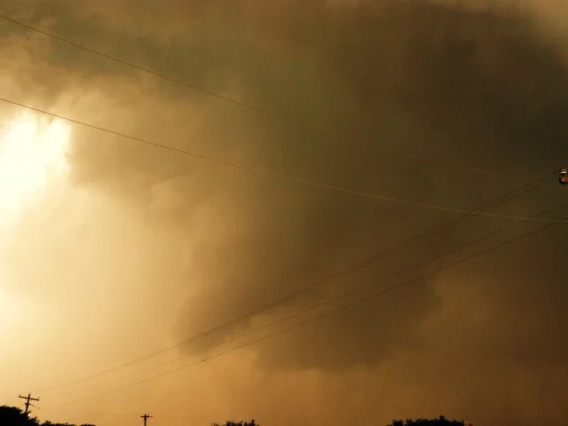
The storm of the day developed near Breckenridge in the wake of the first storm and we came up on this cell from the southeast on some unmarked road and Ranch Road 717 as it was starting to mature and become surface based fairly quickly. The first shot below is what I believe to be a large funnel that did form near Necessity to the southeast of Breckenridge. In the picture you can see the RFD cutting in from the left.This funnel had to have only lasted around a minute, if that, but it did get rather far down. Thereafter, we drove underneath the meso on I-20 to try and get ahead of the storm with a south road option and encountered some rather interesting wind shifts and incredibly fast moving rain curtains as we did so. I have some video of this and, if it looks alright, I may post it later. Saw the TIV on our south road option of Hwy 16 and then got some lightning shots as it turned dark just west of Stephenville as the storm really started to die.
I did take quite a bit of video today, as well as a poorly constructed time lapse. Also, I know the Vortex 2 was not out yet but, wow, there were a ton of chasers down here!It’s wasn’t terribly bad, though, as everyone seemed to mind the road alright and not do anything stupid. Quite the caravan trying to get ahead of the storm and to I-20 in time before we got cored. Needless to say, we made it but, had we been there a few minutes later, we definitely would have gotten cored by the 4 inch hail that some storm chaser reported totaled his car.
This is the supercell quickly developing near Breckenridge, TX. This storm quickly went supercellular and was tornado warned after 45 minutes of initiation.
Here is a funnel cloud to the southeast of Breckenridge, TX.
Another picture of the large funnel cloud to the southeast of Breckenridge, TX. Notice the RFD cutting in from the left of the funnel. The funnel was short lived and only lasted around a minute and did not touch down.
Lightning shot when storm was in dissipating stage near Stephenville, TX.
Another lightning shot near Stephenville, TX at the end of the chase day.
More photos from this day can be found here: http://www.flickr.com/photos/39991047@N02/sets/72157621794019518/


