July 27th Southwest Wisconsin Storm Chase - Supercell and Wall Clouds
07-27-09 CHASE LOG: WI
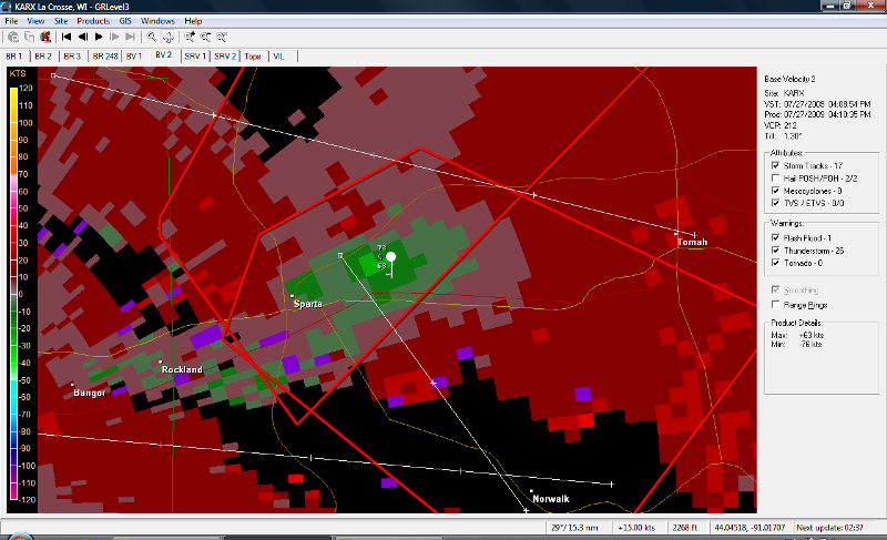
Quite glad that I went out today as MaryLynn and I chased a couple of strong supercells through the rolling hills and trees that is southwest WI.It ended up being a surprisingly good day, all things considering.Upon leaving Burnsville, our course of action took us to Rochester, MN where we waited for initiation as a mesoscale discussion had been issued, talking about the development of supercells with primarily a damaging wind and large hail threat as well as an isolated tornado or two.A severe thunderstorm watch was then issued for all of southeast MN and most of south-central WI into northeast IA.Thunderstorms had already developed across the border right on the warm front into WI and, realizing the trough and associated wind shift were passing to our east, we decided to head east on I-90 towards La Crosse, WI.Storms in WI continued to get their act together and become severe, showing signs of strong rotation as we made it through La Crosse and towards Sparta, WI where we came upon the first storm of the day.This storm was still exhibiting strong signs of rotation and here is where we witnessed the first wall cloud, and a large wall cloud it was, although quite ragged.As the storm passed south of the Interstate near Sparta, we pursued on Hwy 71.This is where the VIL’s spiked and the storm started to have a couplet.We got directly out ahead of the wall cloud at this point as the motion started to greatly increase and inflow winds became stronger, also while we encountered some dime sized hail.I was rather nervous at this point being directly out ahead of the rapidly rotating wall cloud with the storm having a TVS signature on radar but, surprisingly, the storm never produced a funnel through the entire time we were watching, just outside the town of Norwalk, WI. We continued south on County Road T ahead of the storm as different storm became tornado warned 35 miles to our southwest.This was the storm that dropped a confirmed tornado in southwest WI today.We were not able to get to this storm due to the bad road network and the likelihood that we would have to core punch the storm to have any chance of seeing anything.Therefore we stayed on our storm to the north and this storm ended up becoming tornado warned as we were witnessing another developing wall cloud, although short lived.Near Hillsboro, WI is when the chase ended as the storms congealed into a big HP mess.
Back edge of rain shaft on a storm in La Crosse, WI.We had to punch this storm to get out ahead to get to the storm near Sparta, WI.
Large wall cloud on the storm near Sparta, WI. This storm was severe warned for large hail and damaging winds at this time.
Screen shot of the velocity imagery at the time we were approaching this storm near Sparta, WI.
Image of inflow into wall cloud from right to left. Hail/rain core is on the left side of the image.
Velocity imagery near the time we had the strong rotation very close to us in the video.
Wall cloud near Hillsboro, WI shortly before the storm became tornado warned.
Anvil of supercell on I-90 near New Lisbon, WI as we got back on the interstate to head home.
Sunset near St Charles, MN on the drive home with towers going up close to the Twin Cities.
More photos from this day can be found here: http://www.flickr.com/photos/39991047@N02/sets/72157621751427445/detail/


