June 6th Southwest South Dakota and Central Nebraska Storm Chase - Supercell and Small Funnel
06-06-07 STORM CHASE: SD/NE
This was one of the last days of filming for the "Twisters Sisters" reality TV show with our group consisting of myself, Peggy Willenberg, Melanie Metz, Karen Miller, Beau Gjerdingen and Eric Whitehill. This was a highly anticipated moderate risk day with a 10% risk for tornadoes as forecast by the Storm Prediction Center. Our forecast was targeting southwest SD near the Black Hills for tornadoes. Before storms fired, we waited in Murdo, SD on I-90, chatting with other chasers and admiring all of the chaser convergence in a gas station parking lot. Many were anticipating supercells to fire to our west and produce tornadoes upon moving towards our position, hence the reason for the number of chasers that had converged on the area. Storms fired by mid-afternoon and our group quickly raced west on I-90 to Belvidere, SD, then dropped south on Highway 63 to intercept the cell as it became tornado warned. We got on the storm after it had already produced a tornado, around 5 miles to the southwest of Wanblee, SD at the entrance of a ranch. This storm had a lot of motion and originally had a wall cloud leftover from the tornado that we missed by only 20 minutes. This storm produced a weak, short-lived funnel before gusting out as the storm overtook us and we raced east to attempt to stay ahead. The storm continued to exhibit a lot of motion and produced a couple of gustnadoes at this time. After realizing that this storm was turning into a gigantic heavy rain and hail mess with the tornado threat diminishing, our next plan of action was to race east on Highway 18 through southern SD and then drop south on Highway 281 and east on Highway 91 to intercept another supercell around sunset near the town of Sterling, NE. This storm turned the entire sky orange and large hail to the size of nickels was starting to fall as we quickly retreated east of town. Thereafter, it because too dark to see anything, so our plan of action was to drive to Fremont, NE for the night to prepare for the next days High Risk in IA.
Tornado warned storm as we were approaching on Hisle Road ~5 miles southwest of Wanblee, SD.
Small funnel cloud out of a wall cloud, 20 minutes after the storm had produced a tornado to the southwest of Wanblee, SD.
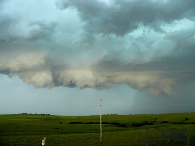
A lot of rising and sinking motion on these lowerings from this storm as it approached.
A lowering that was rapidly rotating and quickly approaching our location near a ranch just outside of Wanblee, SD.
Incredible motion with these clouds as the storm was gusting out upon moving directly overhead.
More photos from this day can be found here: http://www.flickr.com/photos/39991047@N02/sets/72157621675013229/


