
April 29th Northeast Kansas and Southeast Nebraska Storm Chase - Washington Tornado, Several Wall Clouds, and Massive Shelf Cloud
04-29-10 CHASE LOG: KS/NE This ended up being a great chase with several wall clouds, 1 tornado near Washington, KS and probably the best shelf cloud I've ever seen near Belleville, KS. Our chase group consisted of me, Peggy Willenberg, and Melanie Metz. The plan was to stay in Council Bluffs, IA the night before and then target extreme north-central to northeast KS for Thursday's event. Concerns for the day were the lack of moisture and how fast the upper 50's to around 60 dewpoints were going to make it into the area as well as the presence of a rather stout cap as indicated by the morning observed soundings on OAX and TOP. These concerns were alleviated as we traveled down to Concordia, KS to position during the early afternoon and dewpoints were already in the upper 50's with a small pool of lower 60's in northeast KS as moisture had been quickly advected north with the 25-40 mph surface winds and nearly 60 knots at 850 mb over the past 12 hours. Morning forecast models were cooling temperatures aloft across the area as well so there was optimism the cap would break before dark. This was a day of very good low and deep layer shear with modest instability.
By mid-afternoon, a line of enhanced cumulus began developing, out of seemingly nowhere, along the dryline/boundary that was draped from southwest to northeast across the state. Feeling was that this was a dryline due to the 8-10 degree dewpoint drop behind the boundary. We positioned around 8 miles north of Minneapolis, KS at this time to watch the development take place. Within an hour, high based convection began to fire and nice cell started to form to our north. Wanting to get on the first cell of the day, we drove north on Hwy 81 and then east on Hwy 24 and then north on a gravel road through Aurora and (appropriately named) Nelson townships. The storm was starting to get its act together at this point and we could definitely see a nice hail shaft. Trying to take a muddy and slick road east, our truck began to slide and nearly put us in the ditch. However Peggy was able to maintain control and back out to the road we came from. Heading north we finally reached a paved road and went east on Hwy 9 to near Clyde. Our storm had a small lowering at this point but had several updrafts and was starting to become rather messy, while another cell was firing to our southwest. We bailed on the northern cell and went west on Hwy 9 to intercept this new cell that was rapidly developing near Concordia, KS. As we got on this cell on the north side of Concordia, the storm produced a very nice and blocky wall cloud, not rotating at this time but it was the first good indication that the storm was surface based and developing quickly. Cloud bases were lowering dramatically at this point as LCL’s started to come down. As we followed north on Hwy 81 and then east on Hwy 148, the meso began to rotate produced a couple of very picturesque wall clouds to the north of Hwy 148 to the southwest of Washington. Following the storm north on Hwy 15 and then east on Hwy 36 the storm produced a rapidly rotating wall cloud that stirred up a short lived tornado, as indicated by a debris cloud, shortly after 7pm to the north of Washington, KS. After producing the tornado, the storm became loosely organized till there was no wall cloud or even a lowering visible. We decided to bail on this storm around Odell, NE and travel west on Hwy 8 towards Fairbury, NE where a tornado warned storm was moving up from the southwest. Upon moving south of Fairbury on Hwy 15, the storm began gusting out and produced the best shelf cloud I've ever seen! The shelf looked like a snowplow with teeth and was nearly vertical at the front edge, seemingly very near the ground. An interesting feature was noted just to the west of Fairbury at this point where there appeared to be a large wall cloud and possible funnel very close to the ground, becoming embedded in the rain and hail core. A tornado was never reported here but it would not surprise me if one touched down at this point. Wanting to stay ahead of the shelf and not get cored, we traveled back east on Hwy 8 and then ended the chase at this point as night fell.

Big rotating wall cloud to the northeast of Concordia, KS.

Scud being rapidly lifted into the base with strong inflow to the northeast of Concordia, KS.

Incredible, well lit wall cloud wrapping up near Agenda, KS.

Backlit, rapidly rotating wall cloud to the southwest of Washington, KS.
Blocky wall cloud transition taking place with strong rising motion near Washington, KS.

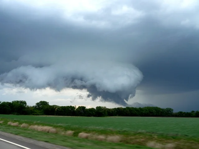
Wall cloud reaching towards the ground shortly before tornado touchdown near Washington, KS.

Very close to the time the tornado near Washington, KS was reported. We did see a brief debris cloud at the base, which you can see in the video below.

Awesome looking shelf cloud near Fairbury, NE. Even better in the video.
More photos from this day can be found here: http://www.flickr.com/photos/39991047@N02/sets/72157623847576173/

Base Reflectivity near time of Washington tornado:

Storm Relative Velocity near time of Washington tornado:
