July 13th, 2010 North Dakota and Minnesota Storm Chase - Slow Moving, Photogenic Supercell
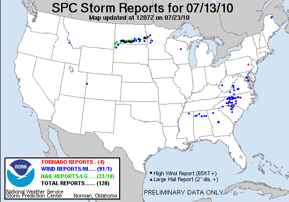
07-13-10 CHASE LOG: ND/MN I did not expect to be storm chasing this day as I had things going on. However, I somehow managed to get everything accomplished by 1 PM and left Burnsville with MaryLynn, targeting extreme northeast SD. The setup was an upper trough approaching this area with an area of low pressure across north-central SD and a warm front draped across northeast SD into west-central MN. This was a modest instability and sheared environment with SB CAPE values of 1000-2000 J/KG nosing northward into the eastern Dakotas and lesser instability and wind shear into MN, while a nose of higher instability was noted further west across central SD. An intense complex of thunderstorms developed north of the warm front, first near Bismarck as we left the Twin Cities and continued to evolve, become surface based, and maintain intensity with supercell characteristics as the storms traveled into southeast ND. We traveled to Ortonville, MN and the thinking was that new storms would fire to the south on the warm front in southeast SD, and we would be in perfect position. However, it became clear that this area was going to remain capped as the cumulus became flat with little to no vertical development. Our only chance at anything was to go north on I-29 and make an attempt to intercept the supercells that were slowly moving into southeast ND. The southern end of the thunderstorm clusters had been tornado warned all afternoon and remained warned as we approached from the south on Hwy 18. The storm had yet to produce a tornado and continued to cycle wall clouds as we followed on east on Cty Rd 2, across I-29 and then east on Cty Hwy 30 in MN. Near the ND/MN border near the town of Christine, the storm produced a low, rotating wall cloud and a large funnel for around a minute. This was the storm’s only shot of producing from when we were on the storm. Near the same time, another storm to the north produced a tornado northeast of Fargo, ND. Overall this was a good chase as the storm we were on had beautiful structure and, at times, a terrific “mothership” appearance. It was nice to be able to follow such a slow moving, photogenic supercell through open terrain without many other chasers around. After the cell crossed into MN, it was getting dark, so we bailed on the storm shortly after 9 PM near I-94. This storm later produced an EF-0 tornado near Dent, MN after dark.
Vault region of supercell near Leonard, ND.
Lowered base under rotating mesocyclone region of supercell near Leonard, ND.
Inflow region and structure of supercell near Walcott, ND.
Another shot of the storm structure and Liberty Bell appearance near Walcott, ND.
Funnel cloud forming on the supercell near Christine, ND.
Another shot of the funnel forming on the supercell near Christine, ND.
Funnel cloud on the storm near the ND/MN border.
Awesome view of the supercell and the storm base east of Wolverton, MN.
Base underneath storm and hail core in the background near I-94 south of Barnesville, MN.
More photos from this day can be found here: http://www.flickr.com/photos/39991047@N02/sets/72157624396366691/
Storm Reports:


