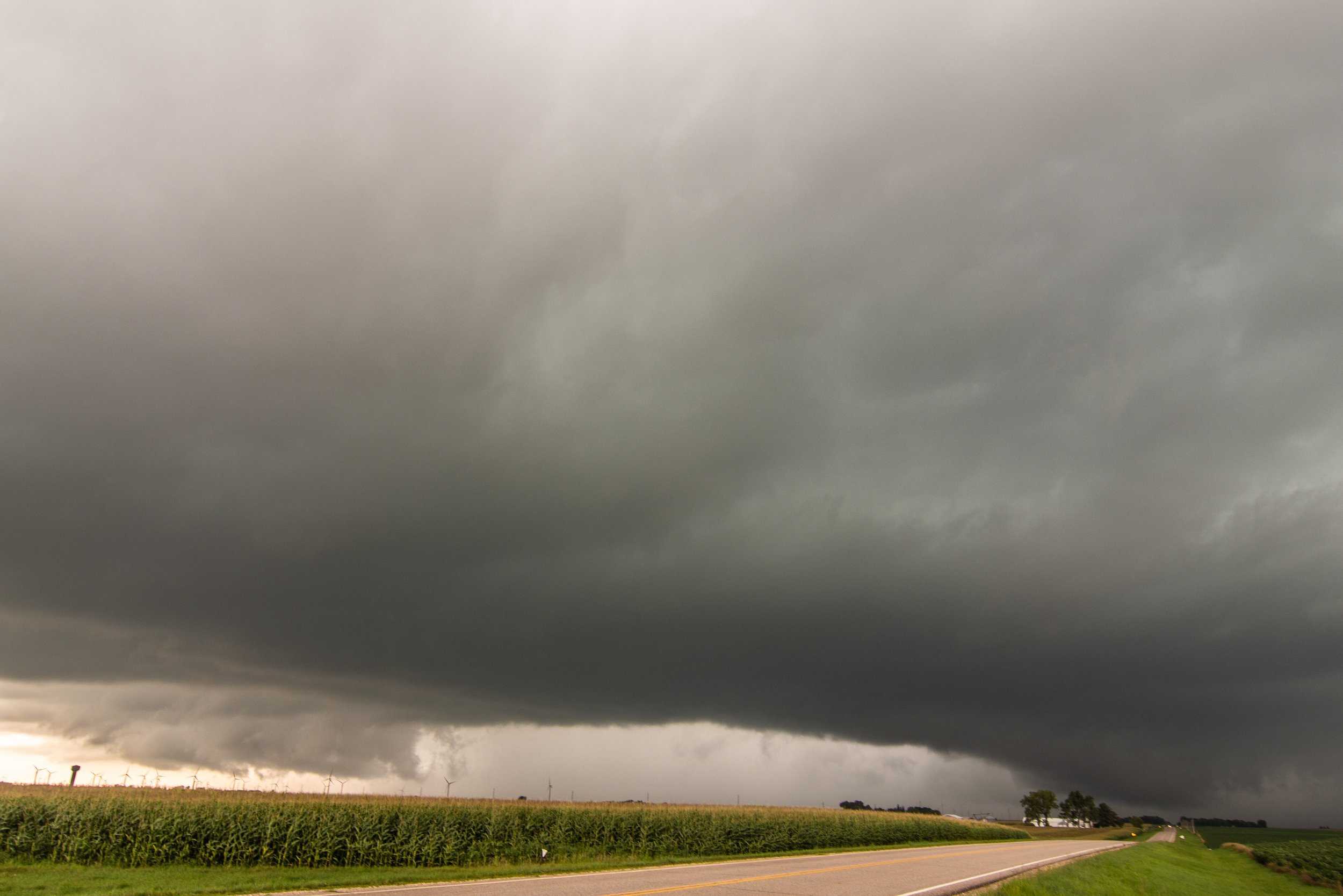


JULY 28, 2021 WISCONSIN: STORM NEARLY DROPPED A TORNADO, CHASING IN WOODED AREA
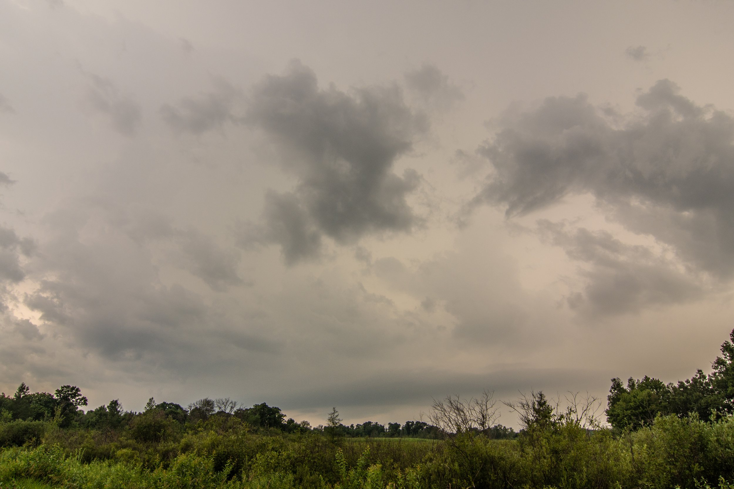
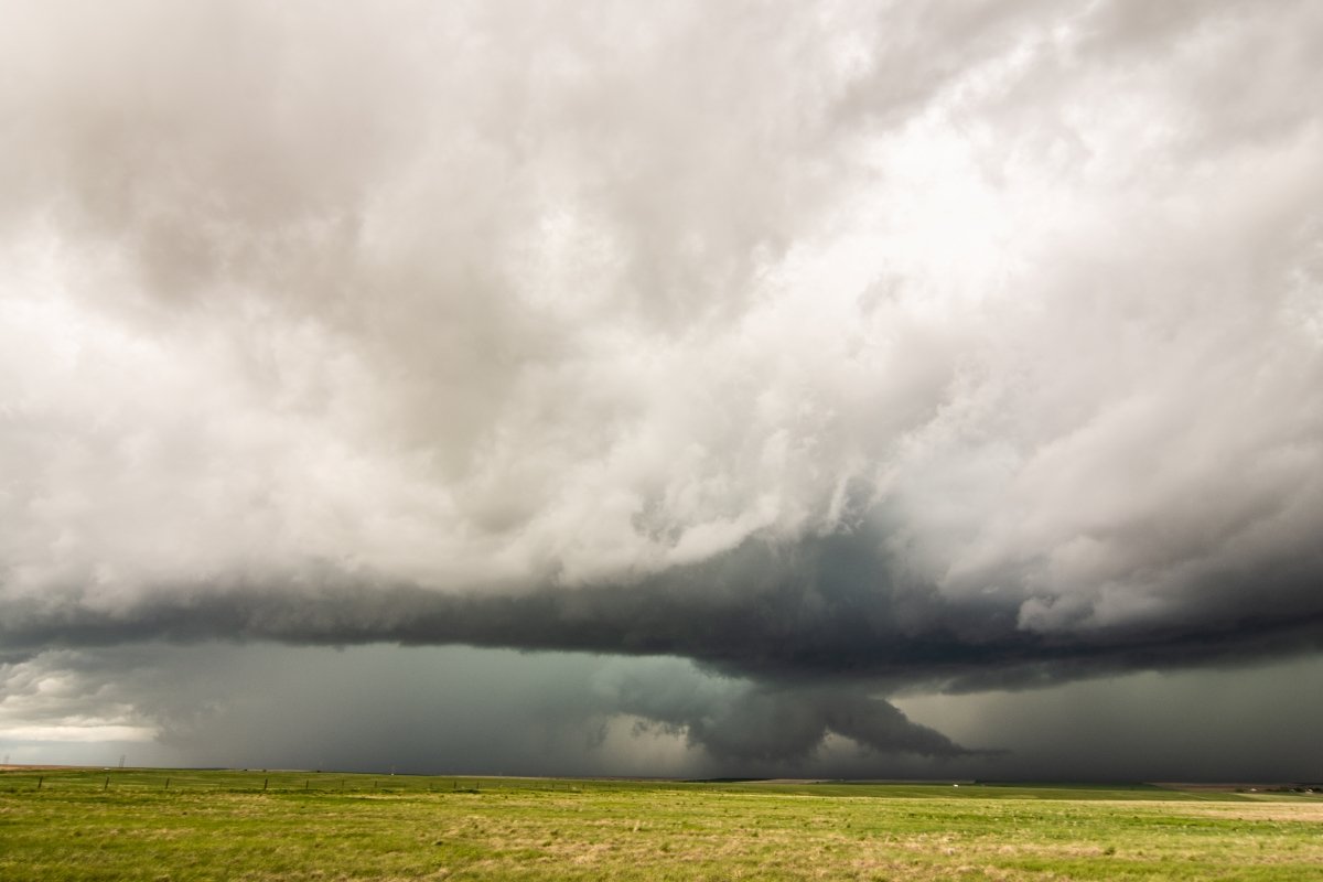
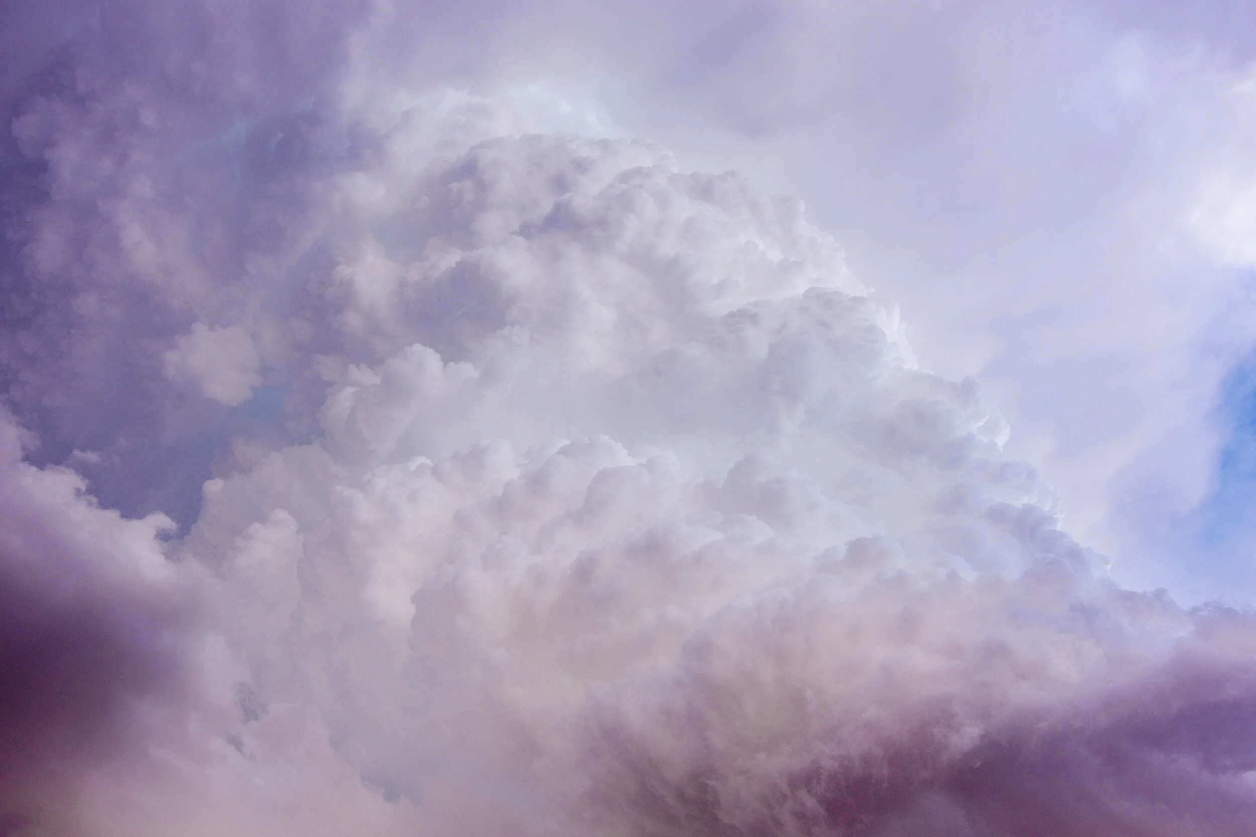
First look at the storm as I pulled up just southeast of it southwest of Grantsburg, WI near the St Croix River. Of course a tree is blocking the view but you can make out the lowering, possible wall cloud in there underneath the storm. This was just before it became tornado warned.

Tornado warned storm about to pass to my west.

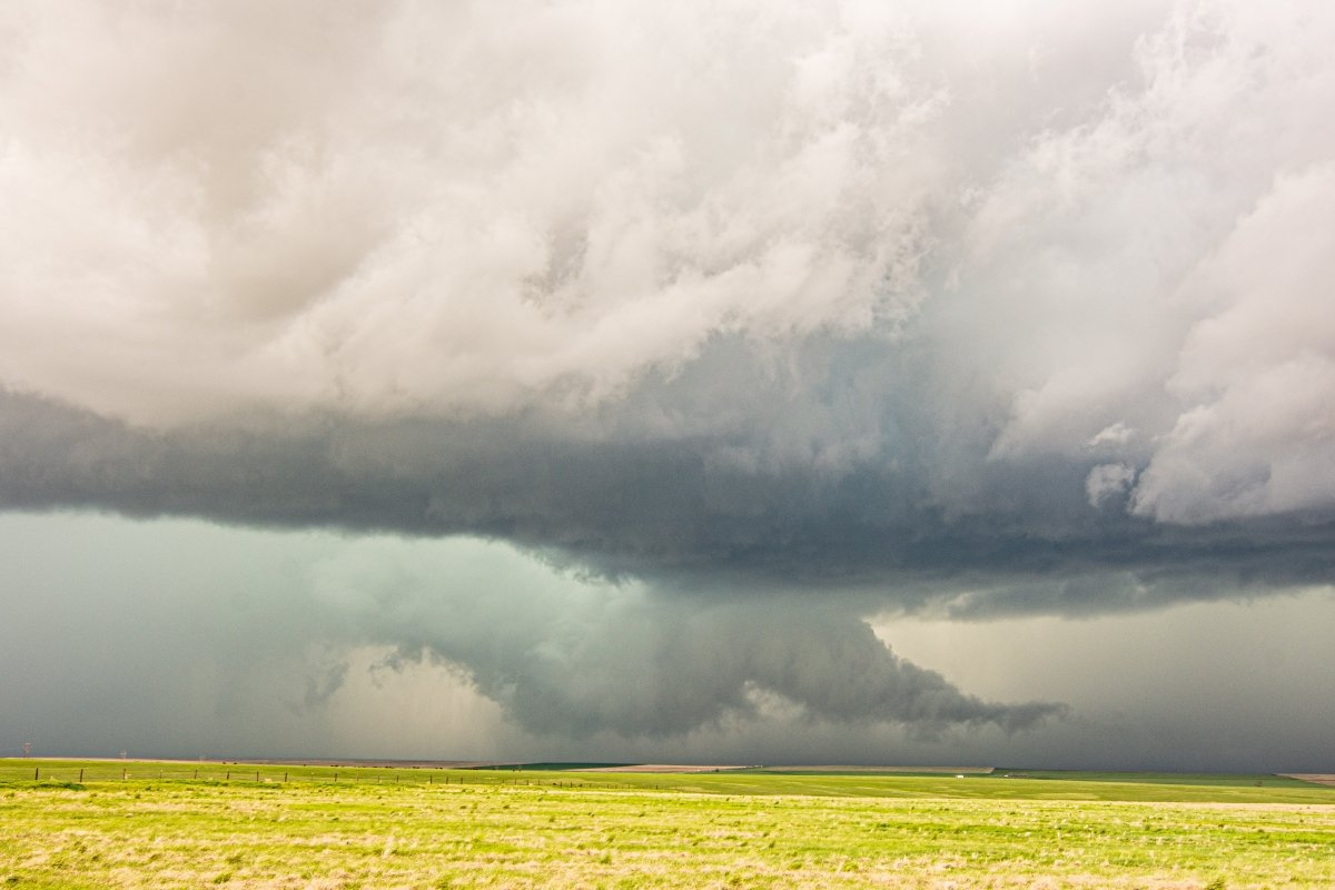
Nice mesocyclone on this storm as it was passing just west of me here and great structure!

I moved west for a closer view before getting cored. Great structure but definitely losing organization. Still have inflow however.

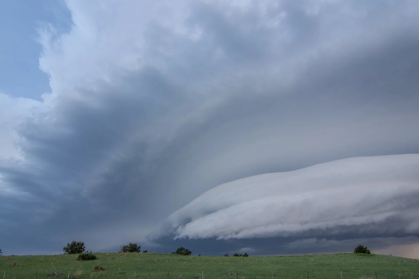
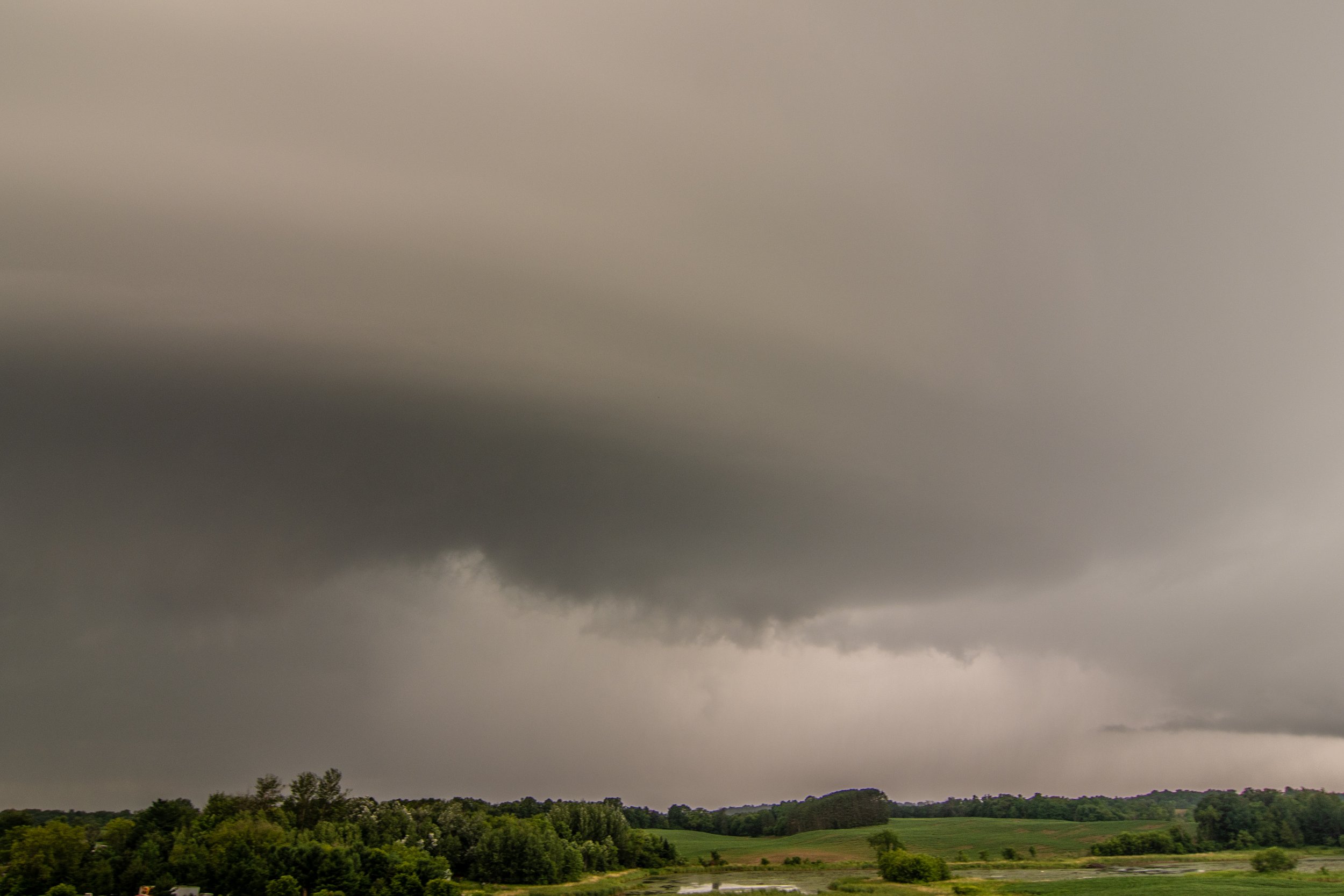
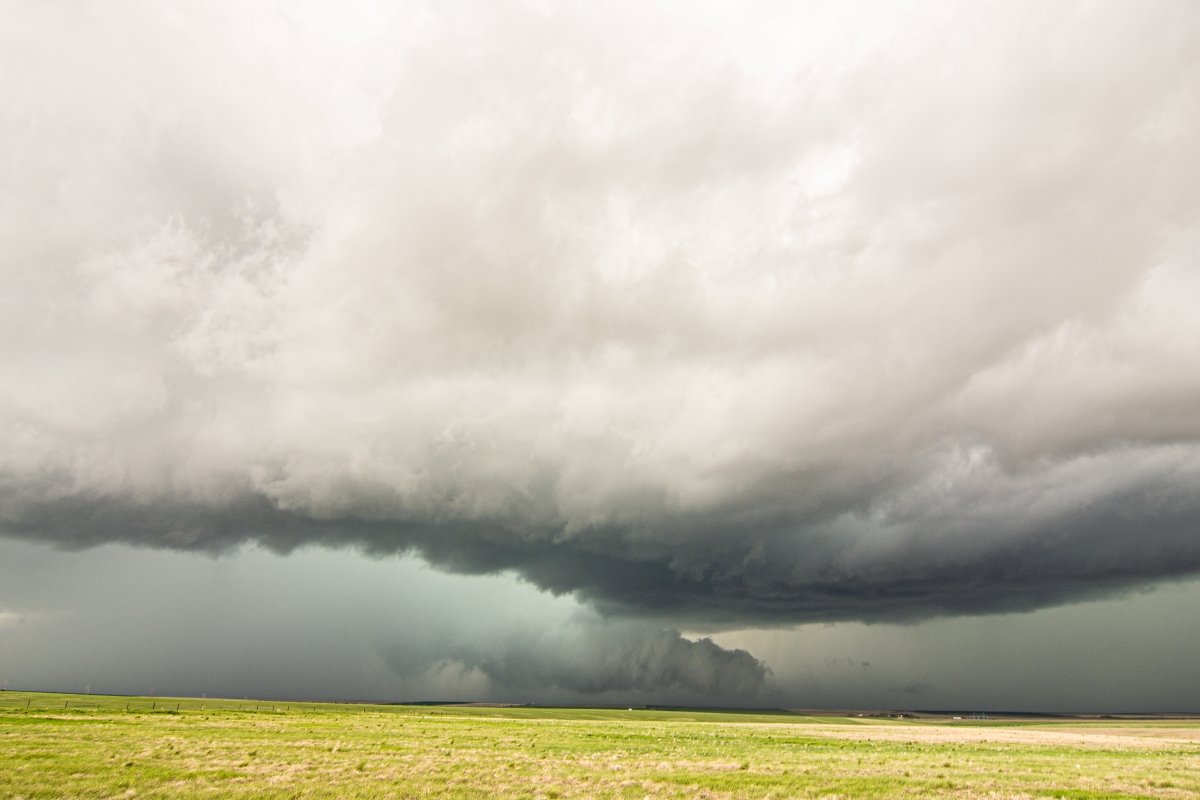
Southern end of the meso as it started to look more like a shelf cloud. I quickly bailed west back to Hwy 87 through the forward flank core to get back south right after this.

All that is left of the occluding wall cloud looking to the north-northwest. Storm still tornado warned.

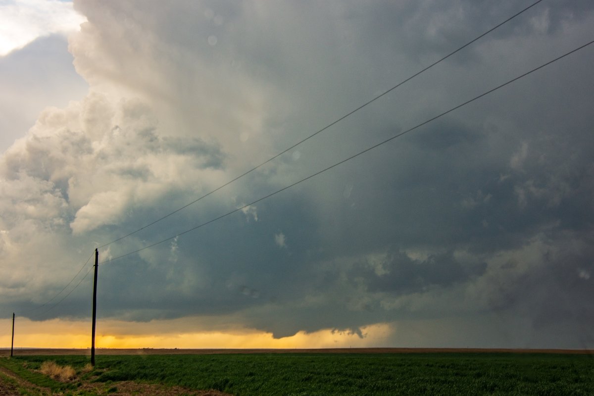
Mothership coming in! This was as I finally got back south ahead of it again near Trade River, WI. Stupid power lines in the shot.
Looking back north it still had an action area and rather unorganized lowering but still holding on to inflow.

Wall of rain about to soon overtake me near Cushing, WI.

Tried to get some lightning shots but not a lot of CG's to speak of. Still the CC lightning was enough to illuminate the storm at dark near Osceola, WI. Scud lowering in there is not a funnel cloud but certainly a look alike.

Last shot of the day as the storm was moving to my due east after sunset. This storm went on to bow out and produce a couple tornadoes and a lot of straight line wind damage as it progressed southeast through the night.


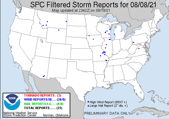
STORM REPORTS:

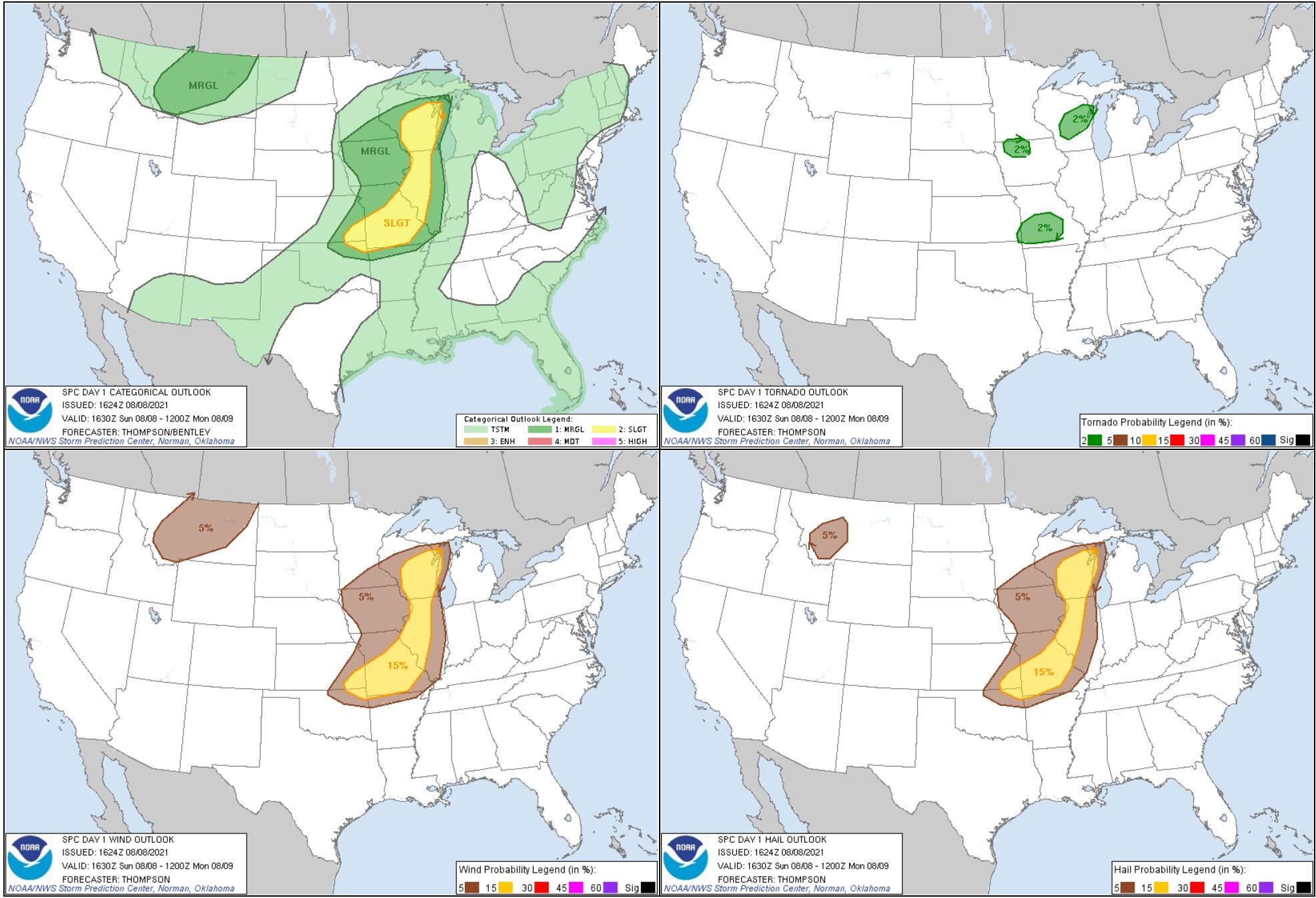
STORM PREDICTION CENTER OUTLOOKS:

JUNE 24, 2021 KANSAS: TORNADO WARNED STORM BUST AND STUCK IN THE MUD

First storm of the day developing near Marysville, Kansas as a tornado watch was being issued.

Wall cloud forming on the storm as we were looking north on Hwy 36 just west of Marysville, Kansas. Storm exhibiting some nice structure here with the spiraled bands above the low level mesocyclone.

Another shot of the wall cloud quickly becoming more mature as we continued to watch stationary at our position for the moment.
We started racing north to intercept the storm and get closer to the action area at this point to the north of Marysville.
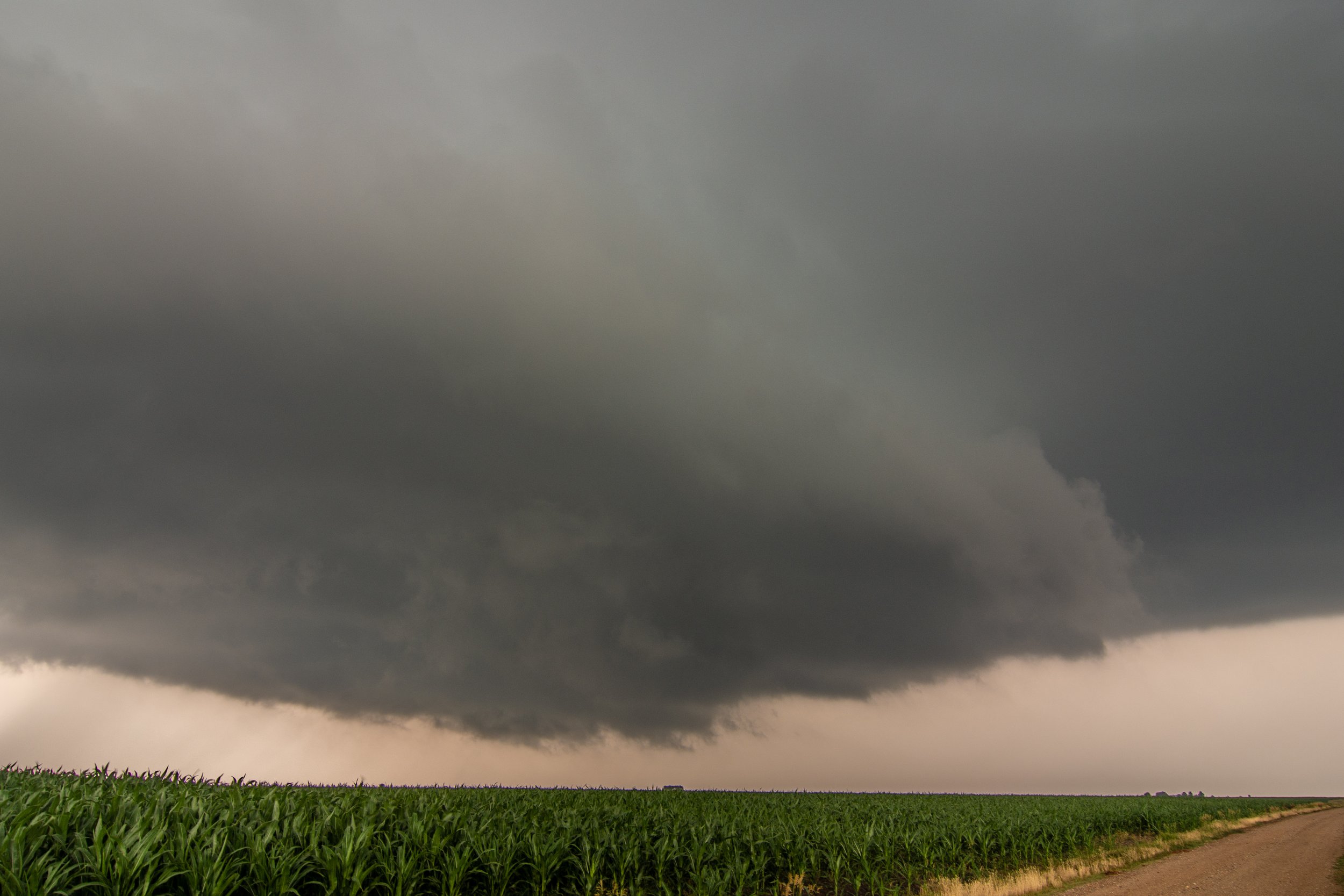
And soon after we got stuck on a blackjack clay road north of Home, Kansas. This is Melanie Metz whom I was chasing with this day trying to clean out some of the mud from around the tires. We were stuck here for over an hour as I had to help push the vehicle a mile back up the road very slowly without going into the ditch. This was the worst I’ve ever been stuck chasing and it ended our day! Very frustrating but storms that kept moving further east really did not do much so we didn’t miss much. We could not drive the vehicle over 30 mph so were forced to drive back to Marysville and luckily found a self service car wash where we spent 3 separate instances spraying out the entire underside of the vehicle, around the tires and inside the wheel wells. Then spent the night in Marysville and chased the next day.


STORM REPORTS:

STORM PREDICTION CENTER OUTLOOKS:

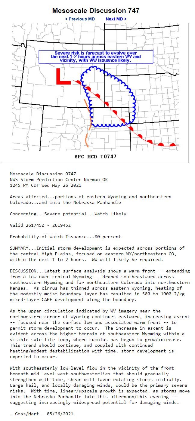
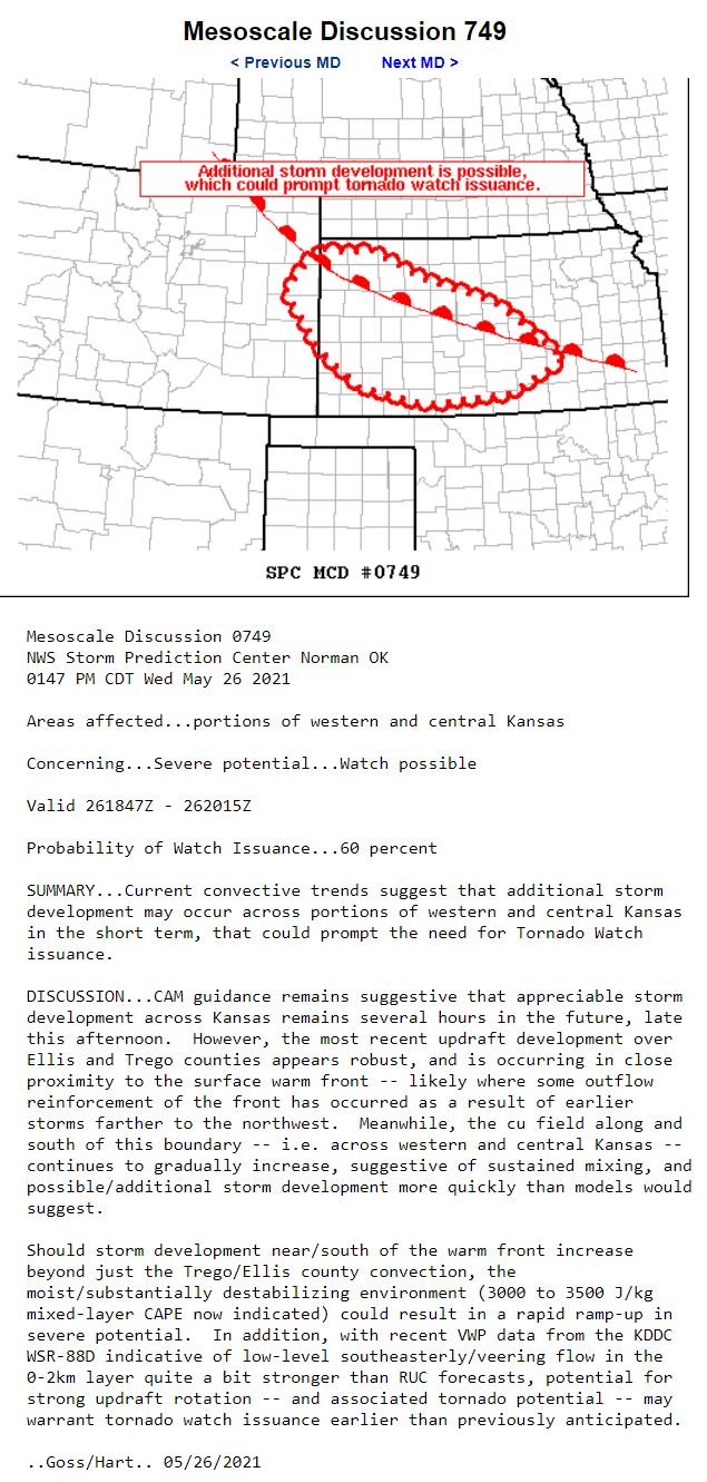
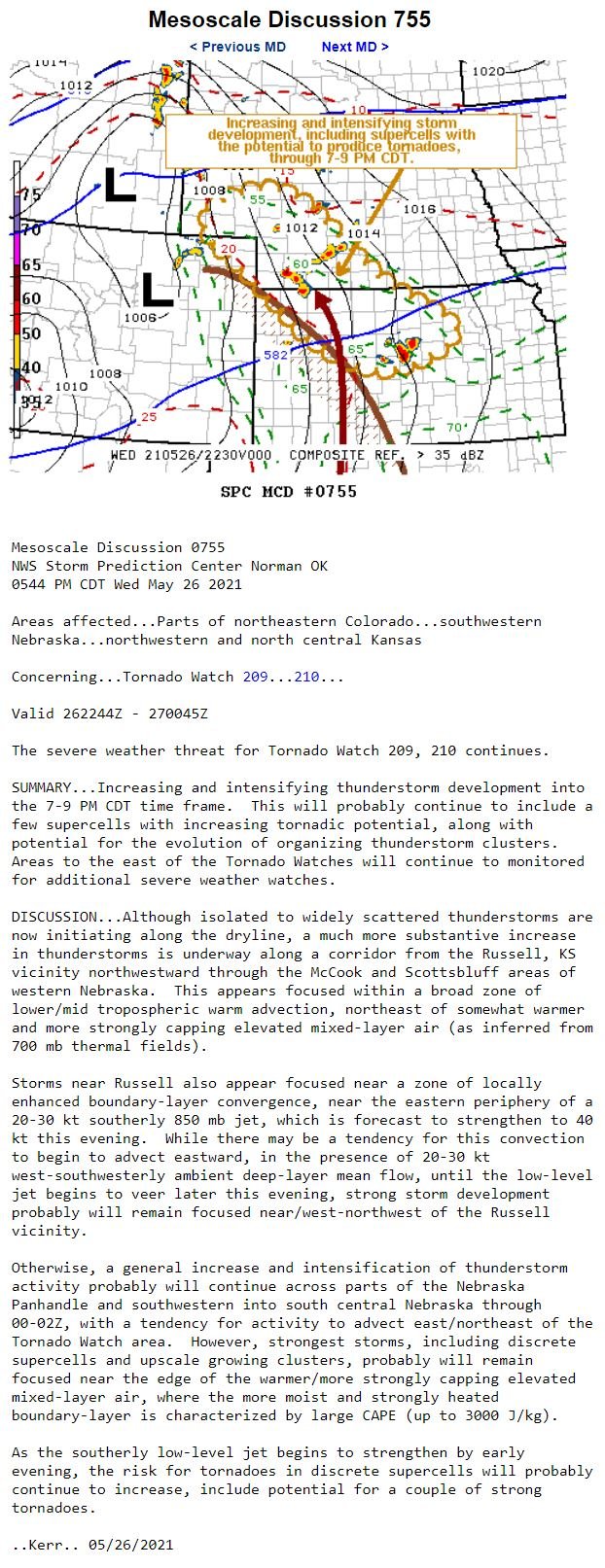
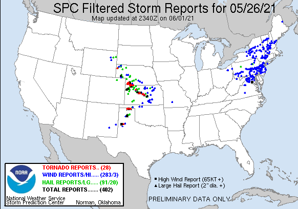
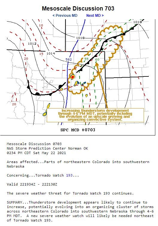
MAY 26, 2021 KANSAS: TORNADO WARNED SUPERCELL STORMS OFF THE DRYLINE

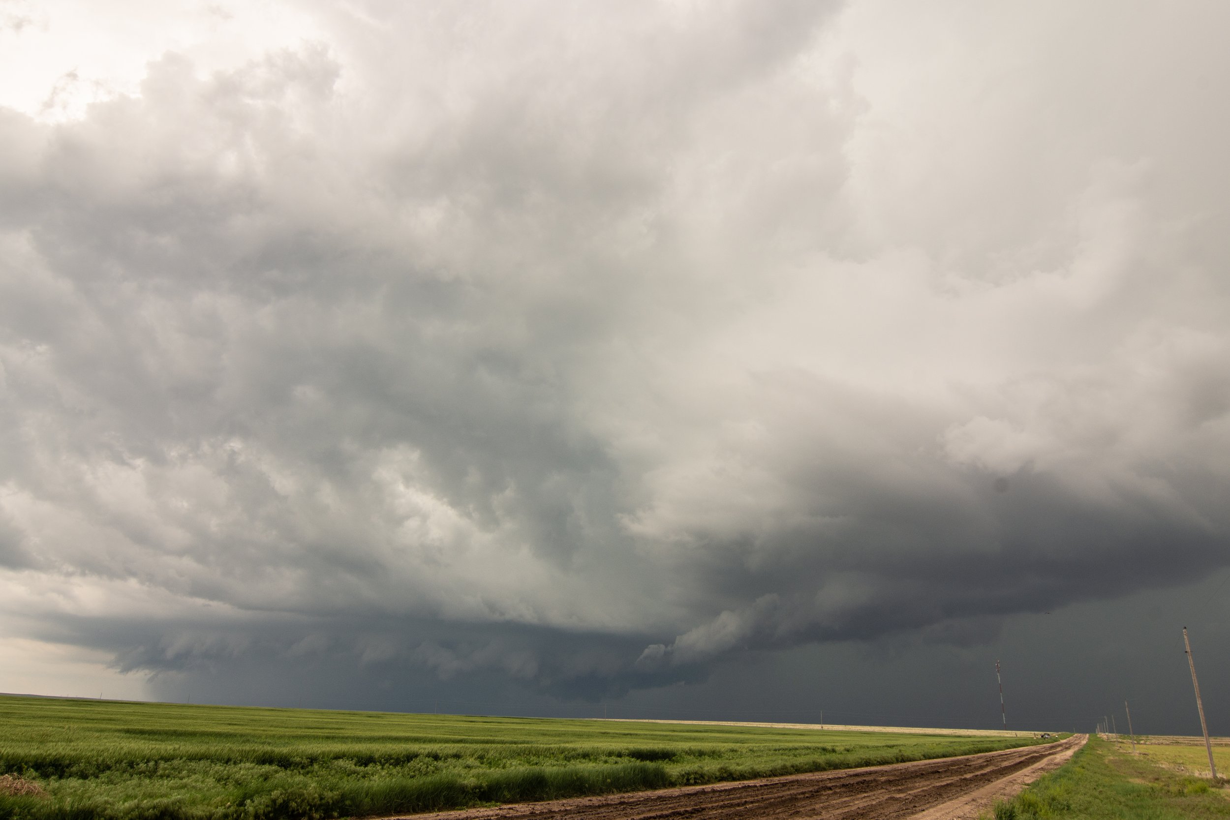
Isolated storm blowing up fast west of Scott City, Kansas on the dryline. PDS tornado watch issued as this storm was developing.

Storm struggling a bit with a skinny updraft and base as we watched near Scott City, Kansas. Can see left split storm base to the right and main storm updraft to the left.
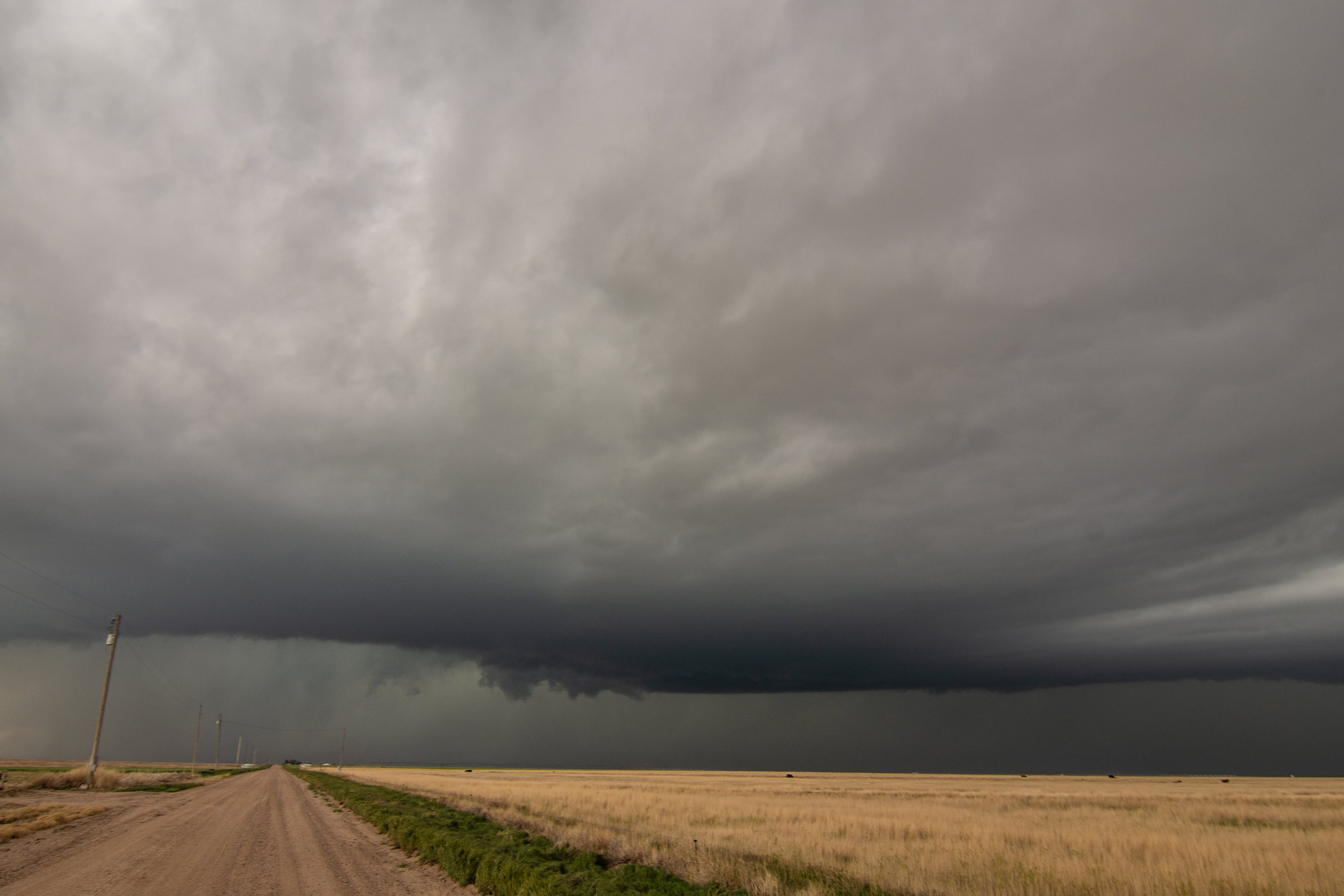
Ended up bailing on our original storm and blasting north to intercept an LP supercell near Grinell, Kansas. This storm was never a threat to produce a tornado but it did exhibit some really good structure.
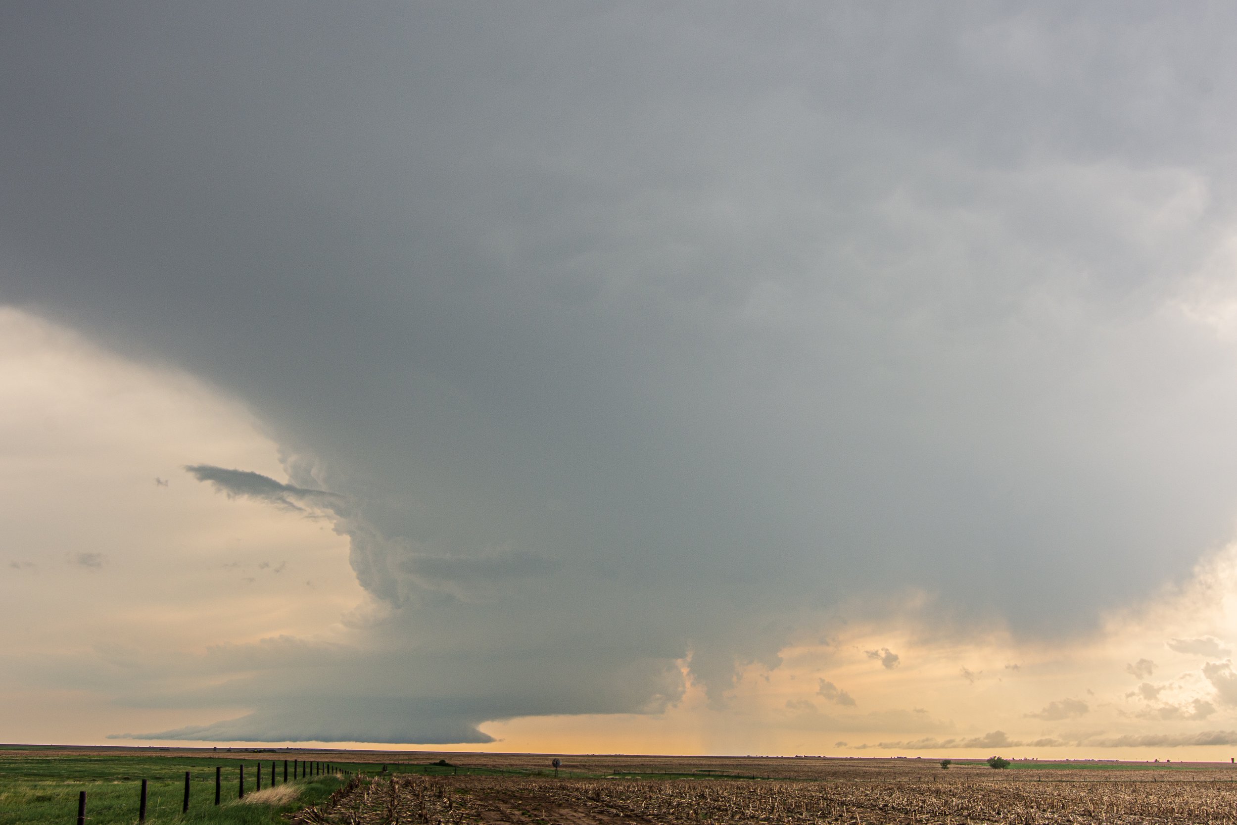


Another tornado warned storm near Lenora, Kansas.

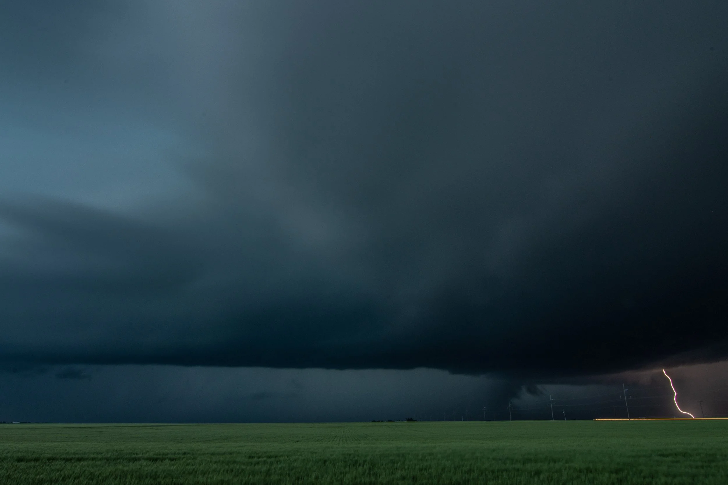
Looking south at a new tornado warned storm and its inflow region. Low storm bases at this point as we approach evening.

Nice C rear flank downdraft cut on this storm near Lenora, Kansas. Certainly was trying to tighten up and produce a tornado here!

MESOSCALE DISCUSSIONS:


WATCHES:


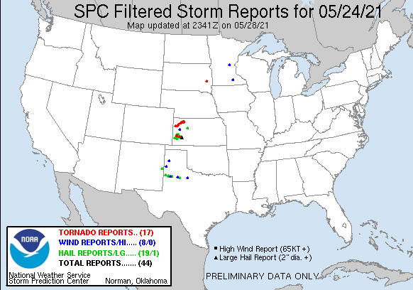
STORM REPORTS:
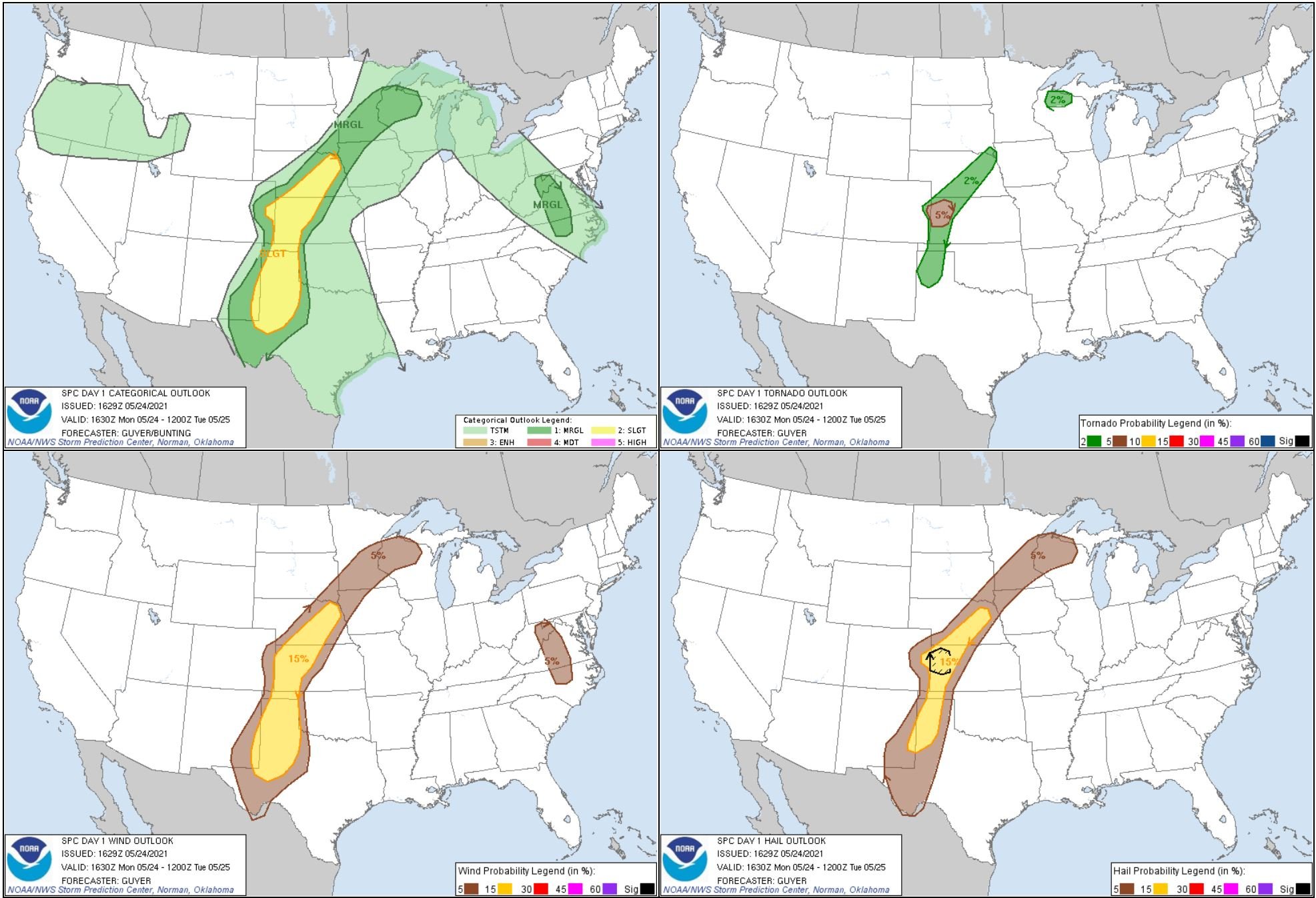
SPC OUTLOOKS:

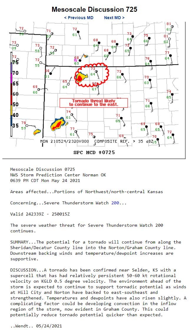
MAY 24, 2021 KANSAS: ONE OF THE BEST STORM STRUCTURE DAYS OF THE YEAR!

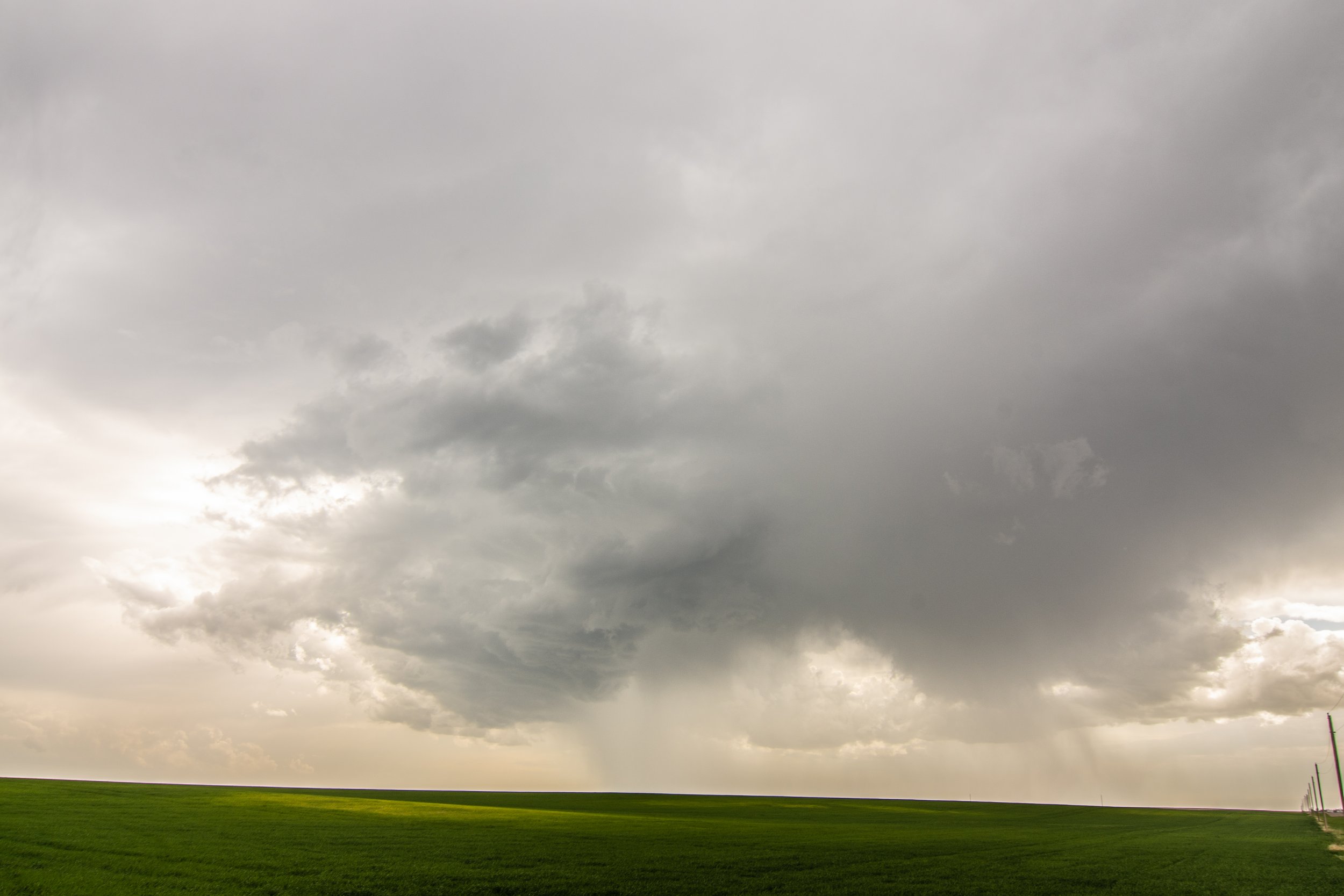
First storm of the day developing near Leoti, Kansas. Strong updraft and dark, flat base immediately as the storm developed.

A short time later as the storm began to split with two distinct updrafts. We had not moved at all from the previous image.

A new storm developing to our southwest as we prepared to reposition.

Wall cloud underneath the storm base near Scott City, Kansas. We could not go up the road any farther due to the mud and risk of getting stuck. This was very close to Little Jerusalem Badlands State Park.

After bailing on the northern storm, we progressed south to intercept a new tornado warned storm near Lakin, Kansas.
Storm starting to exhibit outflow dominant characteristics.

Still some inflow and organized rotation on the northern edge of the storm base here near Lakin, Kansas.


Really nice storm with a wall cloud rotating around the southeast side of the parent mesocyclone near Deerfield, Kansas.

Total occlusion of the wall cloud here with a broad mesocyclone still present.


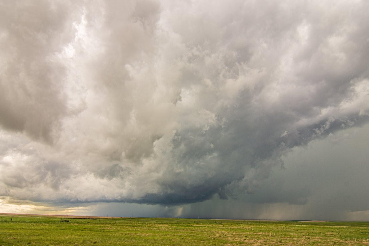
Awesome storm structure near Holcomb, Kansas! The entire storm is rotating. I love that well defined inflow tail.

Wow, what a storm!!!

Best Beaver Tail / Inflow Tail that I saw in 2021. Terrific structure and definition to it!

Impressive wall cloud forming underneath the storm as it approaches us. Looking due west.

What an incredible, beautiful storm. Still well organized and good inflow/outflow balance taking place with a few action areas to monitor just ahead of us.


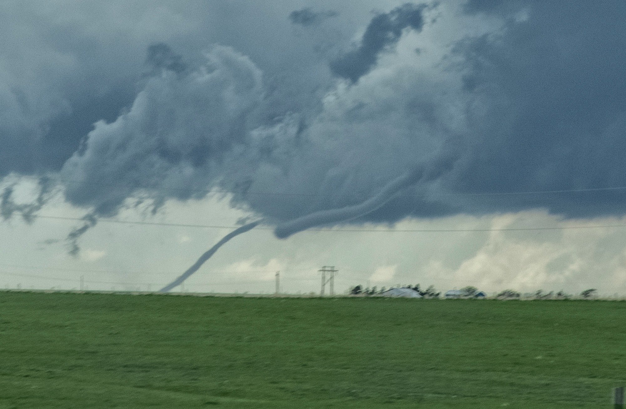
Needle funnel cloud forming under the main action area of the storm.

This is a tornado! Had a debris cloud underneath the wall cloud/funnel right after the clear condensation funnel appeared. It’s subtle but it was there for a short time.

Storm is pretty much done for any tornado threat here. Still severe with a lot of hail and wind though.

Final shot of the day as I was able to grab a lightning bolt with the storm during the evening to the southeast of Holcomb, Kansas.
Mesoscale Discussions:


WATCHES:


STORM REPORTS:
STORM PREDICTION CENTER OUTLOOKS:
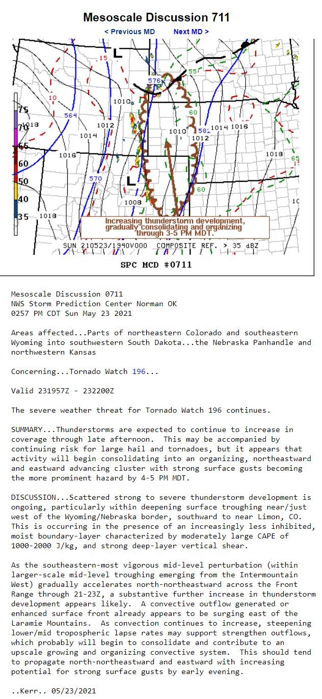
MAY 23, 2021 COLORADO: PHOTOGENIC AND TORNADO WARNED SUPERCELL STORMS
First storm of the day near Rush, Colorado. Already a nice, flat, dark base and intense core on this storm.

Shortly after the previous image was taken, a wall cloud begins to develop on the rotating storm.
AHHHH… this is where it really got interesting as the wall cloud was near ground with strong inflow right to left as noted by the tail.
A closer shot of the wall cloud and inflow tail on the tornado warned storm near Rush, Colorado.

Funnel cloud on the left edge of the wall cloud and just right of the core as the wall cloud began to mature.

Closer view of the funnel cloud and inflow tail with strong right to left inflow at the time.

Storm updraft on a new supercell near Siebert, Colorado.
Funnel cloud starting to form underneath a strong updraft south of Burlington, Colorado.

A new storm we were watching south of Burlington off the dryline.

A new rotating storm we intercepted near Cheyenne Wells, Colorado. Really nice storm we intercepted after the first one!

Storm forming a solid base as it approached the wind farm in front of us.


Storm moving to our north with continued great structure near Cheyenne Wells, Colorado.


STORM REPORTS:

STORM PREDICTION CENTER OUTLOOKS:

MAY 22, 2021 COLORADO: TORNADO NEAR BRUSH, SUPERCELL NEAR GENOA
Roger Hill’s cropped shot of the rope tornado near Brush, Colorado. Blurry due to driving on a bumpy road and trying to get west, closer to the storm at the time. Was barely able to get out of Brush to capture the tornado before it lifted.

Tornado near Brush, Colorado taken by Roger Hill. I was driving and not able to get a photo but Roger was able to get a quick shot before it lifted.

After the tornado, the storm held onto a wall cloud underneath the base and cycled a few more times but did not produce another tornado.

Lots of scud being pulled up into the base with a continued wall cloud southwest of Brush, Colorado.

Wall cloud took on an even more classic, blocky shape as we continued to watch in the same spot southwest of Brush, Colorado.

Another more wide angle shot of the storm and wall cloud just southwest of Brush, Colorado.

After leaving the storm near Brush, we blasted south to intercept another promising storm. Awesome merry-go-round wall cloud spinning away just to our east on this tornado warned storm just a mile north of Genoa, Colorado.

Looking south there was another wall cloud coming up quickly on the left. You can see the northern, more mature wall cloud on the right on this tornado warned storm.

The second wall cloud came up from the south and took on a similar shape as it matured just ahead of us on the road over the wind farm.

The storm eventually occluded the wall cloud/action area to the west of the rain core and held onto some good structure for a while.

Supercell starting to gust out and produce a shelf cloud north of Genoa, Colorado. Big wind maker with a lot of gustnadoes spinning up at this point.

Storm really gusting out hard now with interesting lowerings twisting and turning on the leading edge of the outflow. Gustnado can be seen on the far right. There were many at this point and we drove through one shortly after this shot to the delight of the guests!


STORM REPORTS:

STORM PREDICTION CENTER OUTLOOKS:

MAY 21, 2021 NEBRASKA: STORMS FORMING AS A BACKDROP TO CHIMNEY ROCK
First storm of the day going up near Lorenzo, Nebraska over the wide open and green countryside.

Chimney Rock, Nebraska with storms developing in the background.

Chimney Rock is much more striking when you have storms around!


Silver Lining Tours guest enjoying the view. Tour 4 Primetime Tour 2021 with 3 vans and another photo van in caravan.

STORM REPORTS:

May 20, 2021 Colorado: Sunset Supercell

First storm of the day dumping a hail core near Raymer, Colorado.

Beautiful double rainbow near Carpenter, Wyoming! My favorite of 2021.

Another shot of the double rainbow, albeit with rain drops on the lens as I had a difficult time keeping it dry.

Wall cloud and storm ahead of us on an endless dirt road in the wide open Plains near Padroni, Colorado.

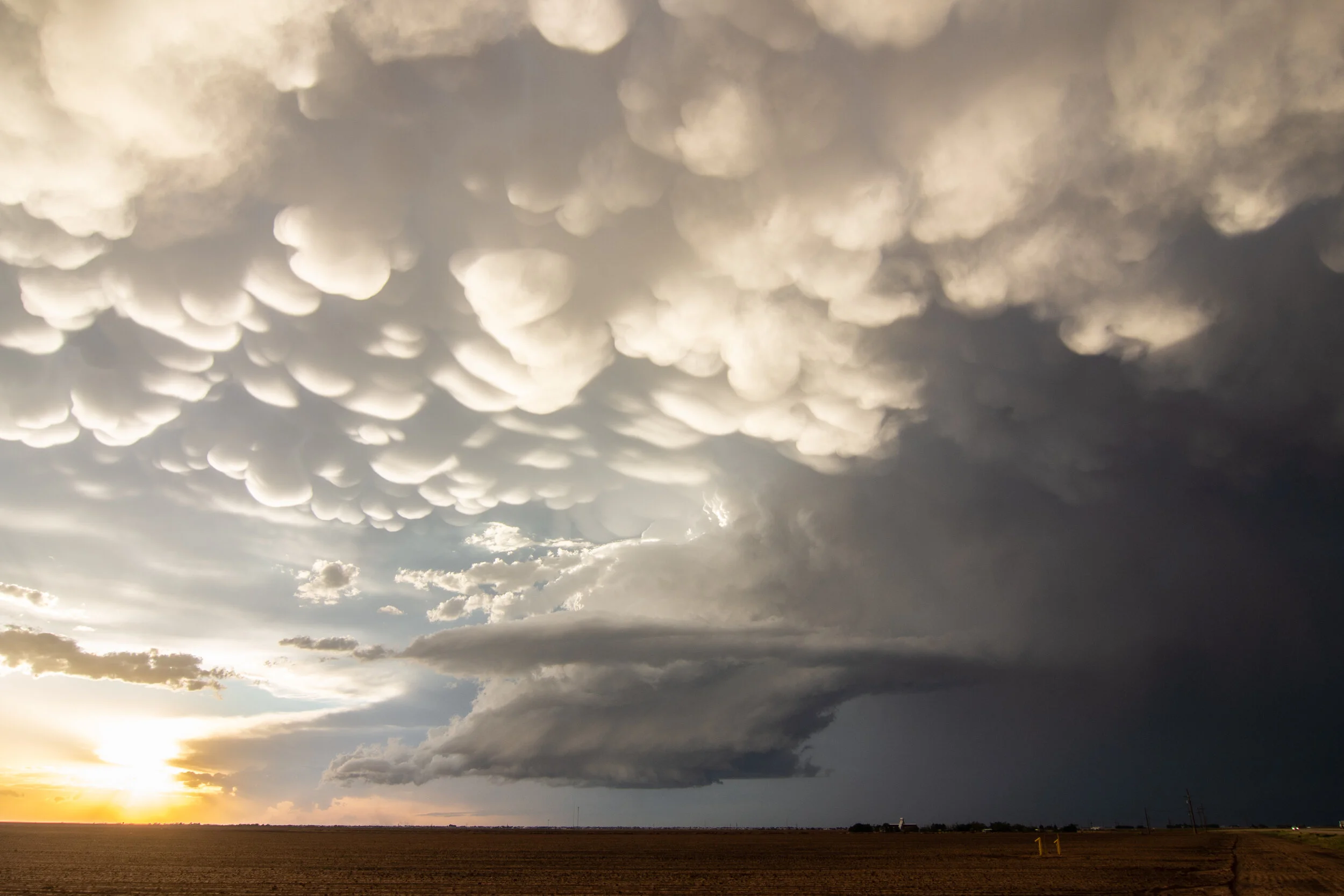
Low precipitation storm on a lonely dirt road as we near sunset with mammatus overhead.

Another shot of the storm as the sun was setting.

It is faint, but there's a cloud to ground lightning bolt in there in the middle of the photo.

Finally get a decent photogenic lightning bolt after the sun has set!

Yes! Another bolt at the end of the day as we were packing up and getting ready to call it a day.

STORM REPORTS:

STORM PREDICTION CENTER OUTLOOKS:

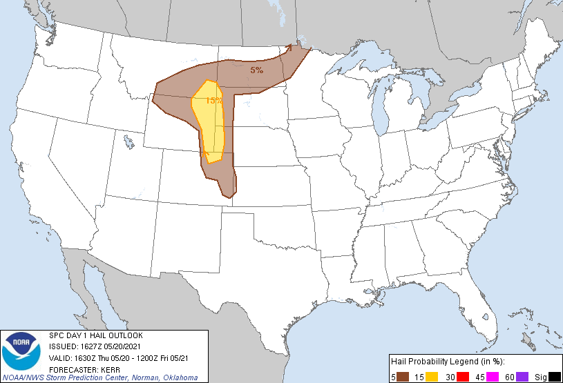


MAY 18, 2021 WEST TEXAS: SOME GOOD SUPERCELL STRUCTURE

Severe thunderstorm near Muleshoe, Texas. High based here but good structure. Can see the rear flank downdraft winds kicking up dirt around the south side of the mesocylcone to the left.

Another shot of the severe thunderstorm as it was approaching use near Muleshoe.

A short time later near Muleshoe as the storm was rolling over a wind farm.


Plenty of inflow bands streaming in and feeding moisture into the supercell at this point!

Long base to this storm with a lot of twisting and turning motion going on here.
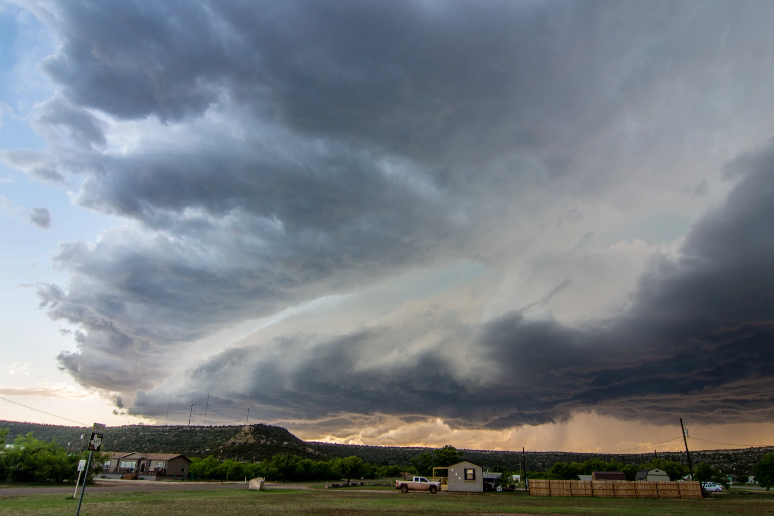
Previously tornado warned storm moving into Gail, Texas. Still severe warned here. Starting to gust out as noted by the developing shelf cloud.

Beautiful storm here near Gail, Texas approaching sunset at the end of our chase day.

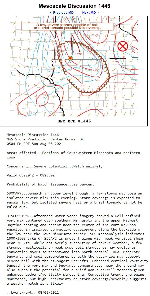
Mesoscale Discussion issued at 1:57 pm CDT. This discussion highlights the potential for a couple supercell storms and brief/weak tornadoes, but overall a limited severe weather risk and only a 20% chance of issuing a watch.
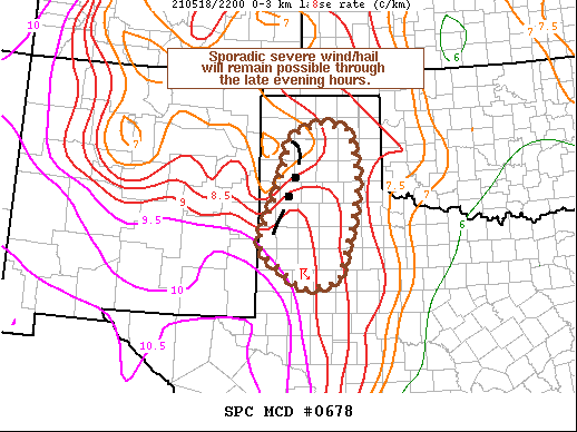
Mesoscale Discussion issued at 6:07 pm CDT highlighting the risk for sporadic severe wind and hail with storms into the evening hours.
STORM REPORTS:

STORM PREDICTION CENTER 1630Z OUTLOOKS:


MAY 17, 2021 WEST TEXAS: A COUPLE TORNADO WARNED SUPERCELLS AND TERRIFIC STRUCTURE

Supercell storm forming off the dryline near Brownfield, Texas.

Storm getting more organized and moving towards us. Good structure with this base and storm updraft. Not much precipitation falling quite yet.
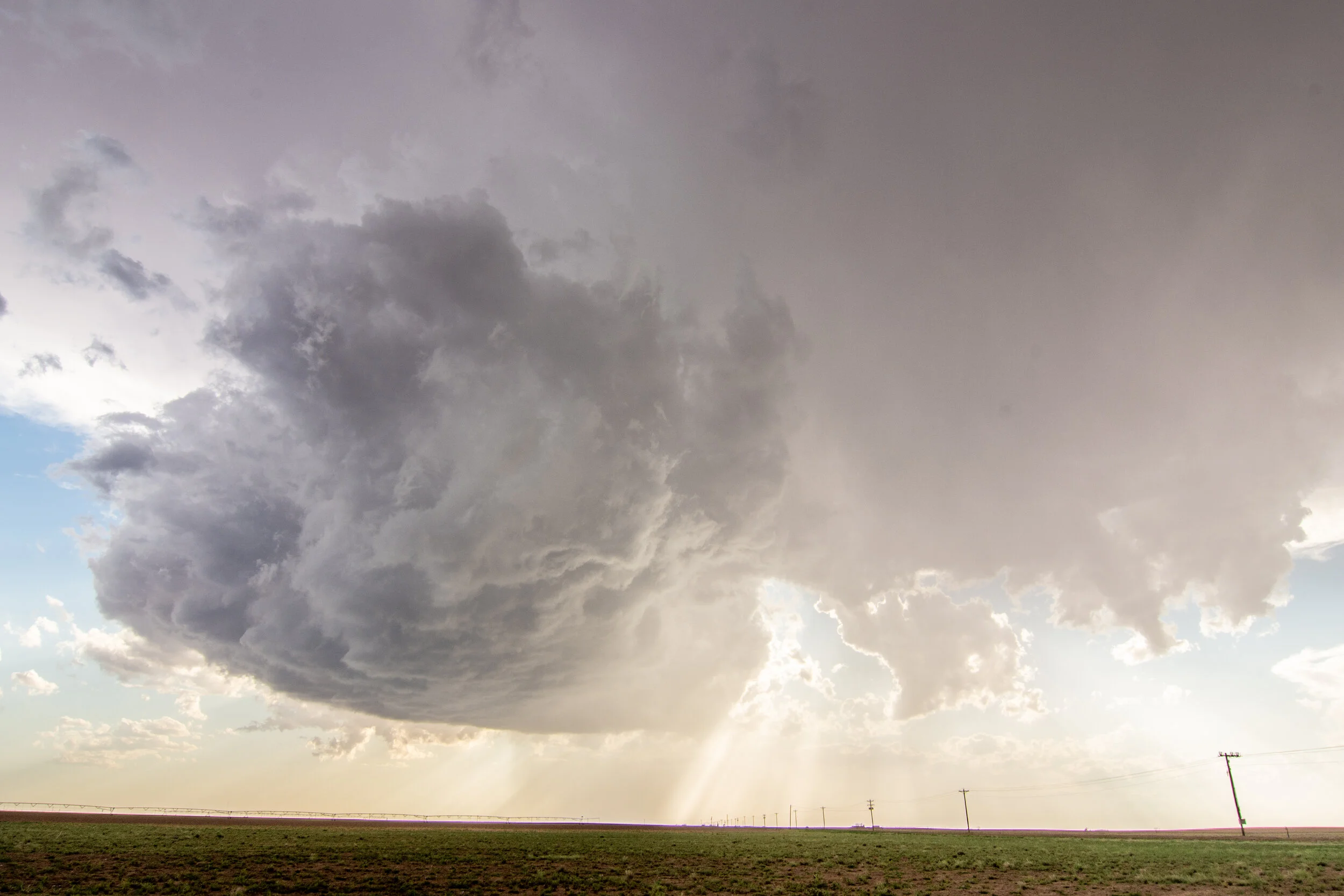
Another shot of the storm slowly moving towards us. Looking west.

Awesome structure with this storm near Brownfield, Texas!

Beautiful storm base and updraft.
Looking up at the storm updraft.

Terrific structure with this storm as Silver Lining Tours guests look on.


Incredible storm and mammatus display at sunset on a new tornado warned storm near Lubbock, Texas!

Looking southwest at the mammatus. Storm is to the right of this vantage point.

Amazing twisting, turning barberpole updraft into the base of this storm.

I am just loving the scene of this storm at sunset! What an end to the day.

Mesoscale Discussion issued at 2:11 pm CDT. Supercell development expected to develop soon near and ahead of the low on the warm front and off the dryline.

Tornado watch issued at 3 pm, valid until 11 pm across nearly all of west Texas.

New mesoscale discussion issued at 5:36 pm CDT.

Mesoscale Discussion issued at 9:44 pm CDT as severe storms continued moving east of I-27.
STORM REPORTS:

STORM PREDICTION CENTER 1630z OUTLOOKS:

MARCH 10, 2021 MINNESOTA: EARLY SEASON TORNADO WARNED STORMS

The first cumulus towers going up on the western side of Owatonna, MN as we watched in anticipation from the John Deere parking lot. Notice the snow piles still around.

Pronounced wall cloud with the storm near Faribault, MN, looking southwest. Could not tell if it was rotating but was there for a while.

Ground scraping inflow as the storm between Faribault and Dundas, MN rode the warm front. Seriously on the ground!! Impressively low LCL's.

Another shot of the ground scraping inflow along the warm front feeding what I presumed was the wall cloud coming around the south end of the storm here.

This was interesting as a bowl lowering on a tornado warned storm was rotating near Shieldsville, MN. Looking from the north to south and just getting out of nickel size hail so was a tough vantage point.

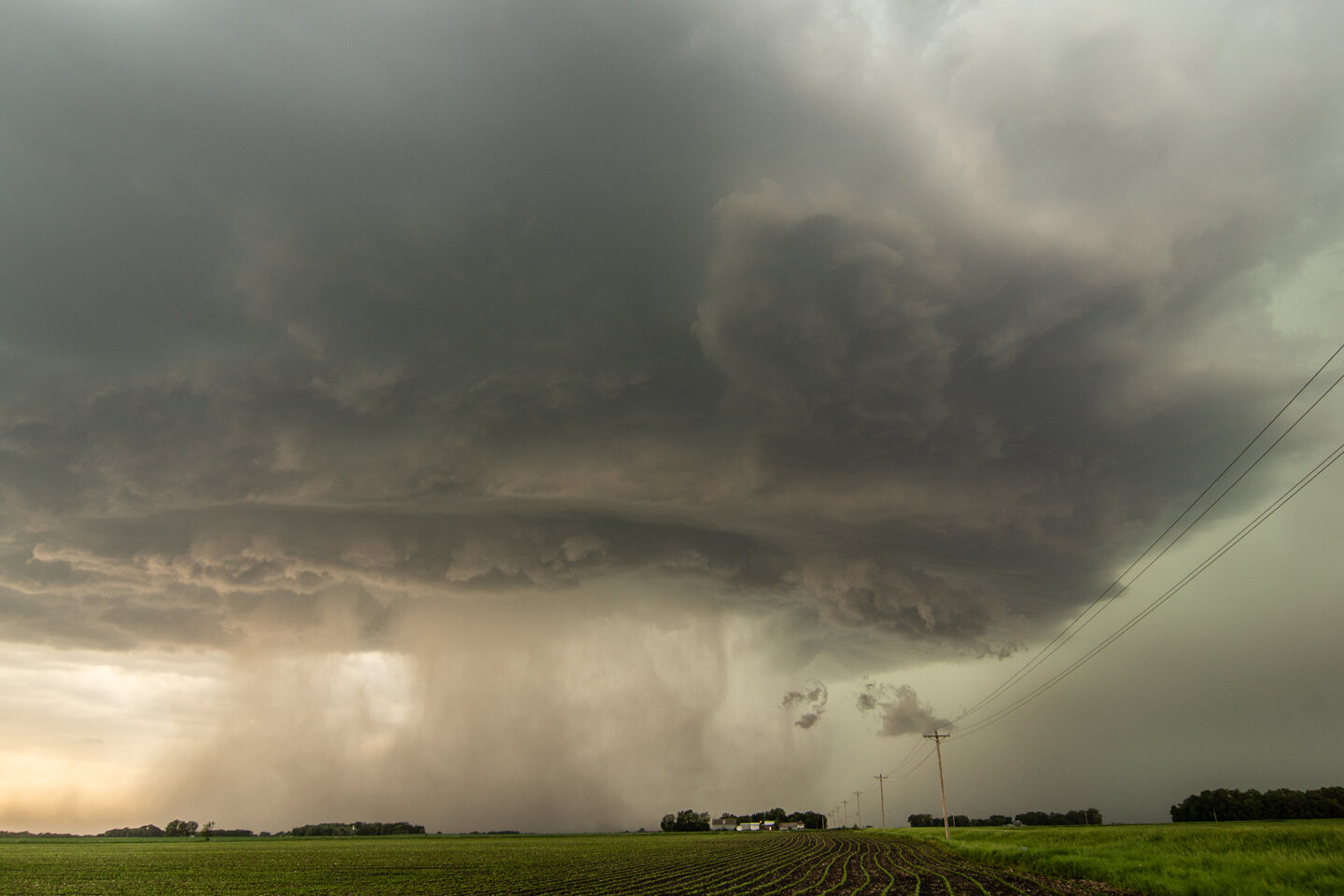
Lots going on here. This was near Stanton, MN. So much motion in the clouds here and broad rotation around this action area. We had strong RFD at one point as we got east of the hook. Was just not organized enough and couldn't tighten up.

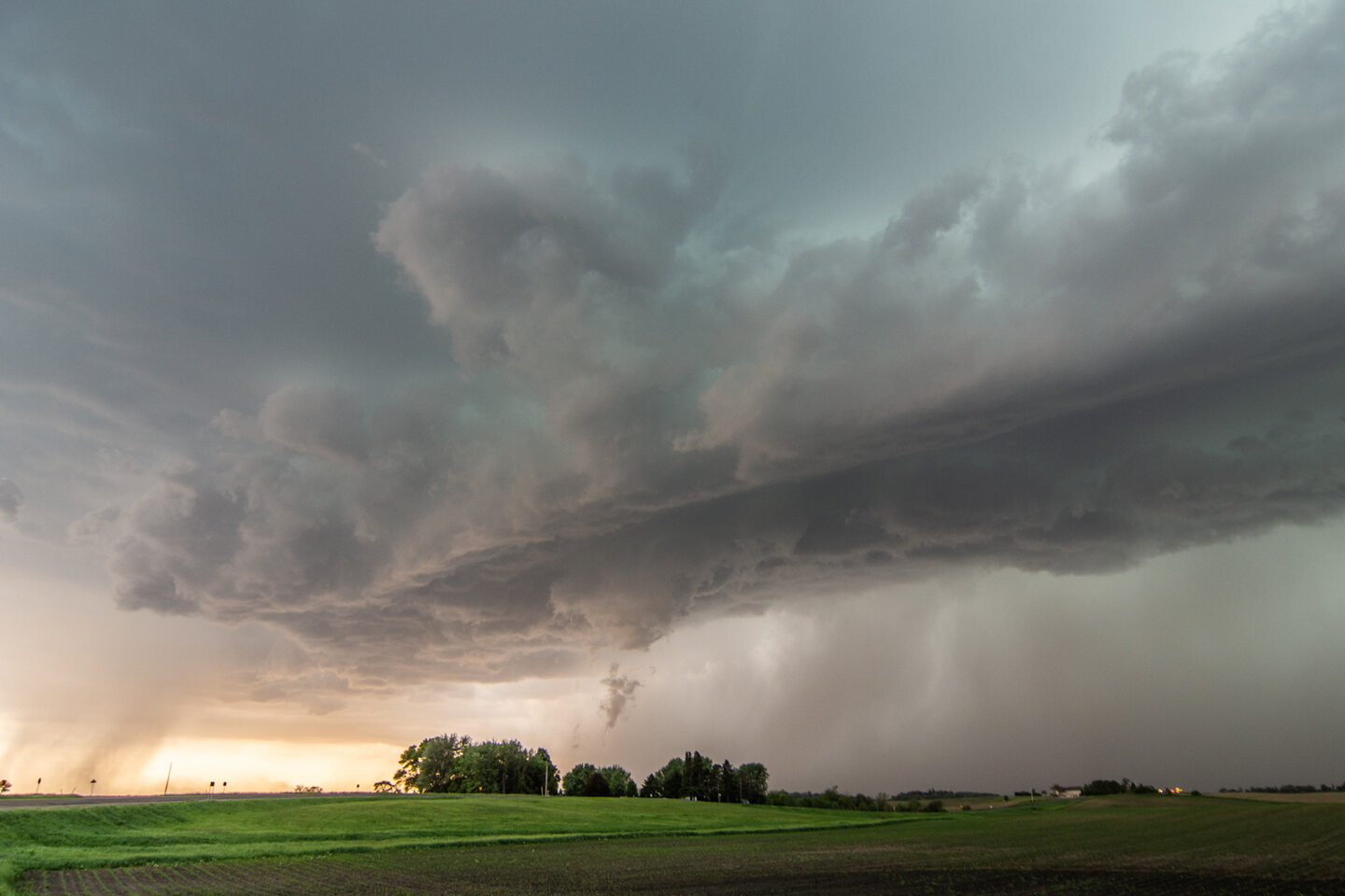
Awesome structure on the tornado warned supercell near Randolph, MN! Shot out the front window. Wish we would have stopped to take more photos here. Massive lowering.

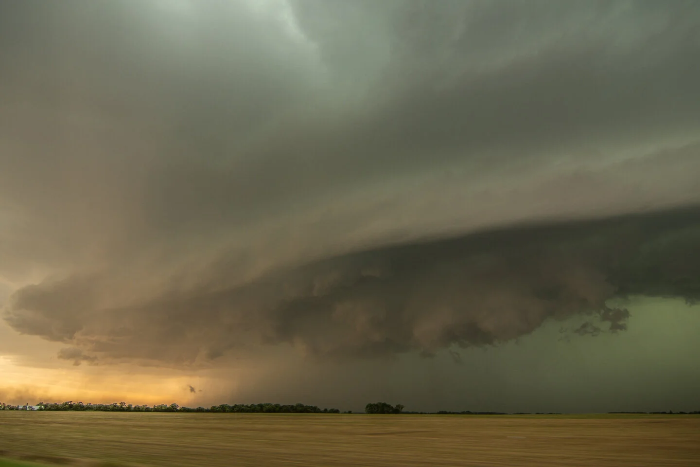
Wrapping up nicely between Cannon Falls and Miesville, MN. This whole thing was rotating and the area to the right of the road was reaching for the ground. Nice structure to this updraft reaching of the supercell.

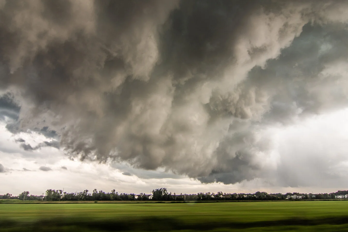
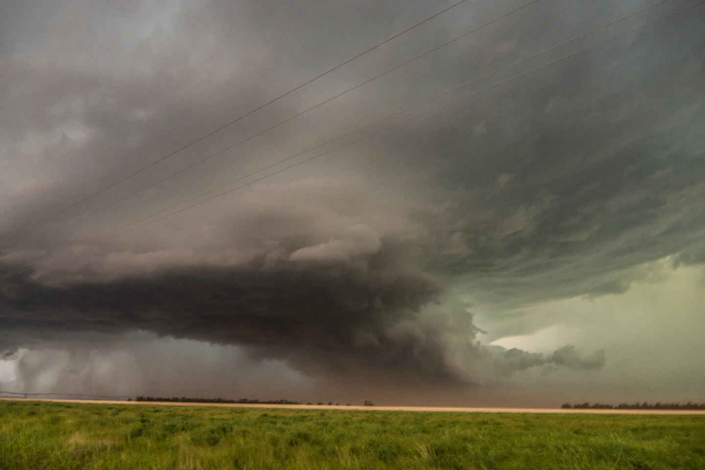
Beast mode supercell between Miesville and Hastings, MN. You can see the inflow tail on the right feeding the storm that was latched onto the warm front here. Left side was coming around very fast with the rear flank downdraft. That cloud bank on the leading edge of the RFD was literally on the ground.

Another shot of the storm right before we drove north right into it. Got down to very low visibility and gusty winds once we hit that low cloud bank.

Mesoscale Discussion issued at 1:32 p.m. CST indicating severe thunderstorm development by 21Z. Watch issuance probability at 60%. https://www.spc.noaa.gov/products/md/md0150.html


New Mesoscale Discussion issued at 5:43 p.m. CST as the severe potential continues with an isolated tornado threat: https://www.spc.noaa.gov/products/md/md0152.html
STORM REPORTS:

STORM PREDICTION CENTER OUTLOOKS:


JULY 18, 2020 MINNESOTA: TORNADO WARNED STORM THROUGH NORTHERN TWIN CITIES METRO

Met up with Roger Hill, Rusty Nelson and the Silver Lining Tours crew in Willmar, MN as we waited for storms to initiate. Good to see them and catch up!

Storm developed further east than we were expecting. Had to blast back east towards the Twin Cities. This is the initial storm updraft looking southeast from Annandale, MN towards Brooklyn Park.

A nervous moment as we watched this wall cloud mature, driving on Hwy 14/Main Street from Coon Rapids into Blaine. Inflow right to left into the wall cloud and condensation/rotation with that small dark feature on the right side underneath the wall cloud as it was trying to produce a funnel. Glad it didn't drop a tornado in the northern suburbs!

Wall cloud on what is now a tornado warned storm in Blaine, MN.

Another shot of the wall cloud in Blaine, MN as it was tightening up and becoming better organized.
Turbulent underside of the wall cloud as it overtook us and moved to our southeast. This was as we were approaching White Bear Lake.

East of Hugo, MN the storm became even better organized. Thought it was going to produce a tornado here!

Driving back home after our chase had ended. Beautiful storm erupting at sunset over Eagan, MN.

Taken from my driveway. Love this shot of two storm updrafts approaching Farmington and gap in between!

Shot of the storm to the east of our house, lit by lightning in the evening.

Mesoscale discussion issued at 3:12 PM CDT for central and southern Minnesota into northwest Wisconsin. 95% chance of watch issuance! Strong instability nosing into the southern half of Minnesota. https://www.spc.noaa.gov/products/md/2020/md1264.html

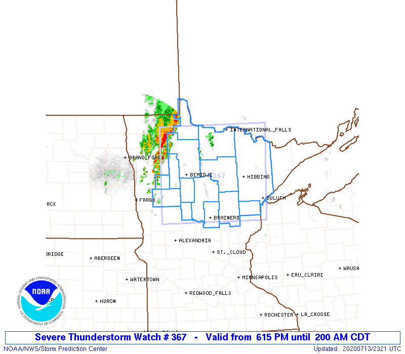
Severe thunderstorm watch issued at 3:55 PM CDT. https://www.spc.noaa.gov/products/watch/2020/ww0382.html

The next mesoscale discussion issued at 6:15 PM CDT as one lone tornado warned storm was trucking through the northern Twin Cities metro (which we were on), while new storms were developing west and north. https://www.spc.noaa.gov/products/md/2020/md1267.html

Mesoscale discussion issued at 8:36 PM CDT for most of northern Wisconsin and the UP of Michigan. Severe storms moving east into Wisconsin. This was near when we called off the chase north of Hudson, WI and let the storms go. https://www.spc.noaa.gov/products/md/2020/md1268.html

Severe thunderstorm watch issued at 9:40 PM CDT ahead of the developing broken squall line now across western Wisconsin. https://www.spc.noaa.gov/products/watch/2020/ww0383.html
STORM REPORTS:

STORM PREDICTION CENTER OUTLOOKS:

JULY 13, 2020 MINNESOTA: WAITING AROUND FOR A GOOD EVENING STORM

An intense rain and hail core on our initial storm to the southwest of Ottertail, Minnesota.

Vertical shot of the storm updraft above the intense rain and hail core.

Wall cloud forming on the storm with quick right to left condensation into the base.

Vibrant colors at sunset as the storm approached us near Deer Creek, Minnesota.

Magnificent color and storm structure at sunset!

Looking back to the east the other direction from the previous photo. Love the color of the blue sky and the backlit clouds from the setting sun.
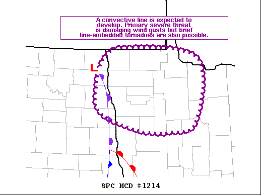
Mesoscale discussion issued at 3:52 PM CDT for northwest Minnesota ahead of the occlusion and low. We were just outside of this MD on the southern end near the triple point. https://www.spc.noaa.gov/products/md/2020/md1214.html

Mesoscale discussion issued at 7:34 PM CDT as new severe storms were expected to form during the evening ahead of the cold front. We were on the far northern end of this MD near Ottertail watching a strong storm towards sunset. https://www.spc.noaa.gov/products/md/2020/md1217.html
STORM REPORTS:

STORM PREDICTION CENTER OUTLOOKS:

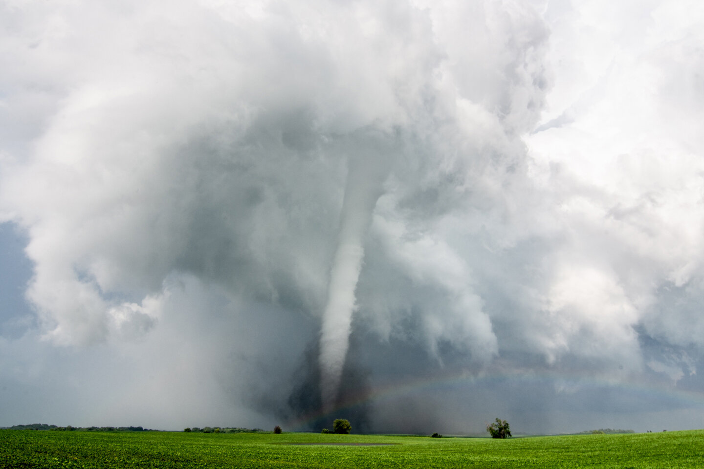
JULY 8, 2020 MINNESOTA: AN EPIC EF4 TORNADO INTERCEPT AND #100 OF MY CHASING CAREER!!
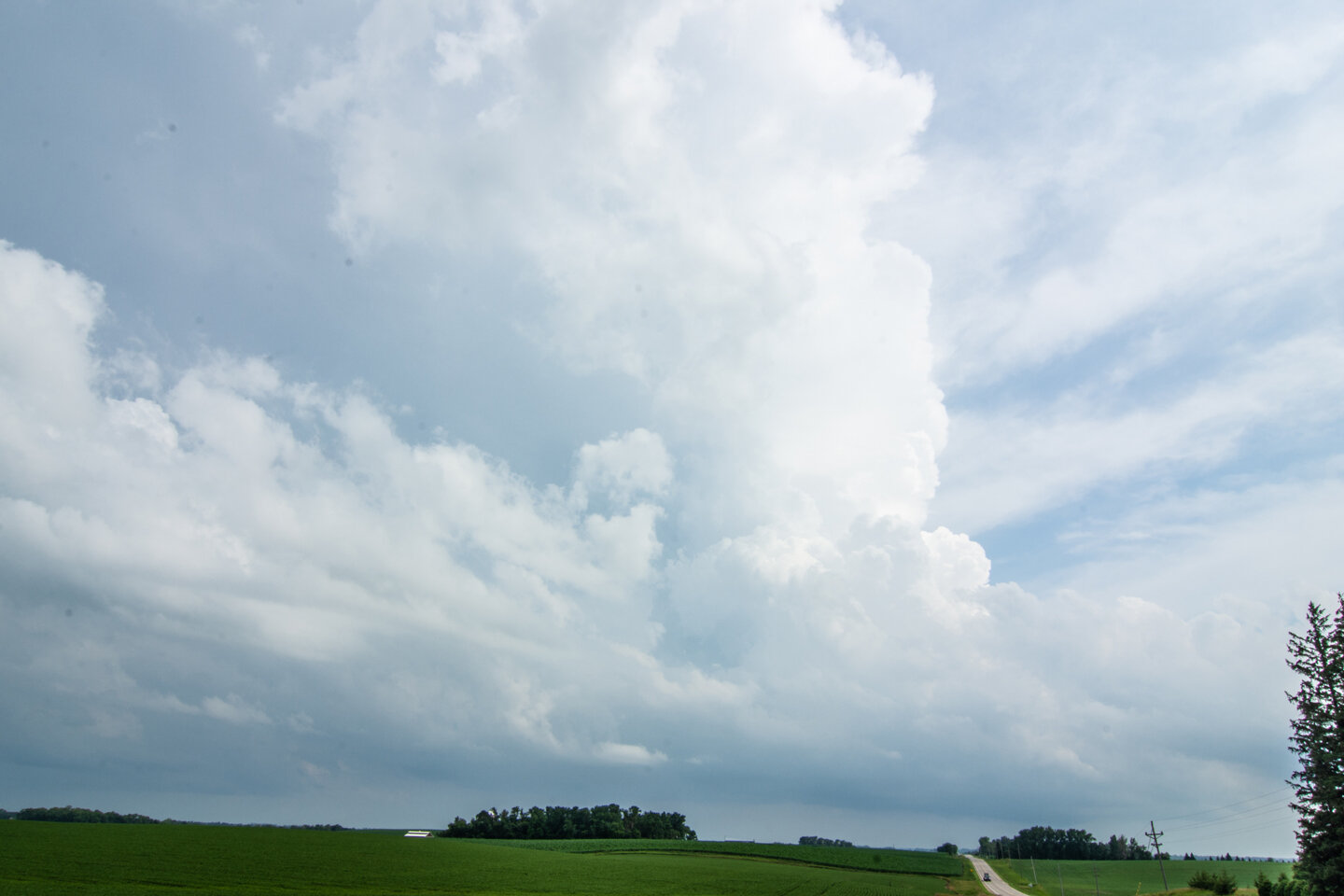
We were fortunate to be right on this storm at the initial updraft at it was punching through the CAP southeast of Fergus Falls, Minnesota. Stopped for 15 minutes to gas up and use the restroom and BOOM! the storm went up fast right on the warm front and ahead of the triple point.

Wall cloud formed 20 minutes after the initial updraft went up. When this happens and you already have a lowering in a favorable storm environment, you know something special could happen. This was looking from the north near Dalton as the storm was moving northeast.

Low contrast here but this was the initial tornado touchdown looking south from Dalton on Hwy 82 shortly after the last photo.

Driving southeast on Hwy 82 as the tornadic circulation strengthens and the tornado “plants”. Perfect road to continue safely southeast as the tornado moves to the left (northeast) across I-94 at this point.

Another shot of the tornado as we stopped near Hwy 82 and 130th St.

Drove right up to the tornado as it slowly moved across Hwy 82, unfortunately hit a structure, and started throwing a lot of dirt in the debris field! Tornado was moving from our right and into the photo and left out of the photo. Did not want to turn left here as there was concern we would end up too close to the tornado path.

UNBELIEVABLE!! At this point I knew we were witnessing a monster. Intense tornado with large debris field. We could hear the roar of the tornado at this point and smell all of the dirt, trees, and debris being chewed up and lofted. Can count on one hand the times I have experienced such exhilaration of the chase.

Absolutely stunning tornado as we stood watching in awe.
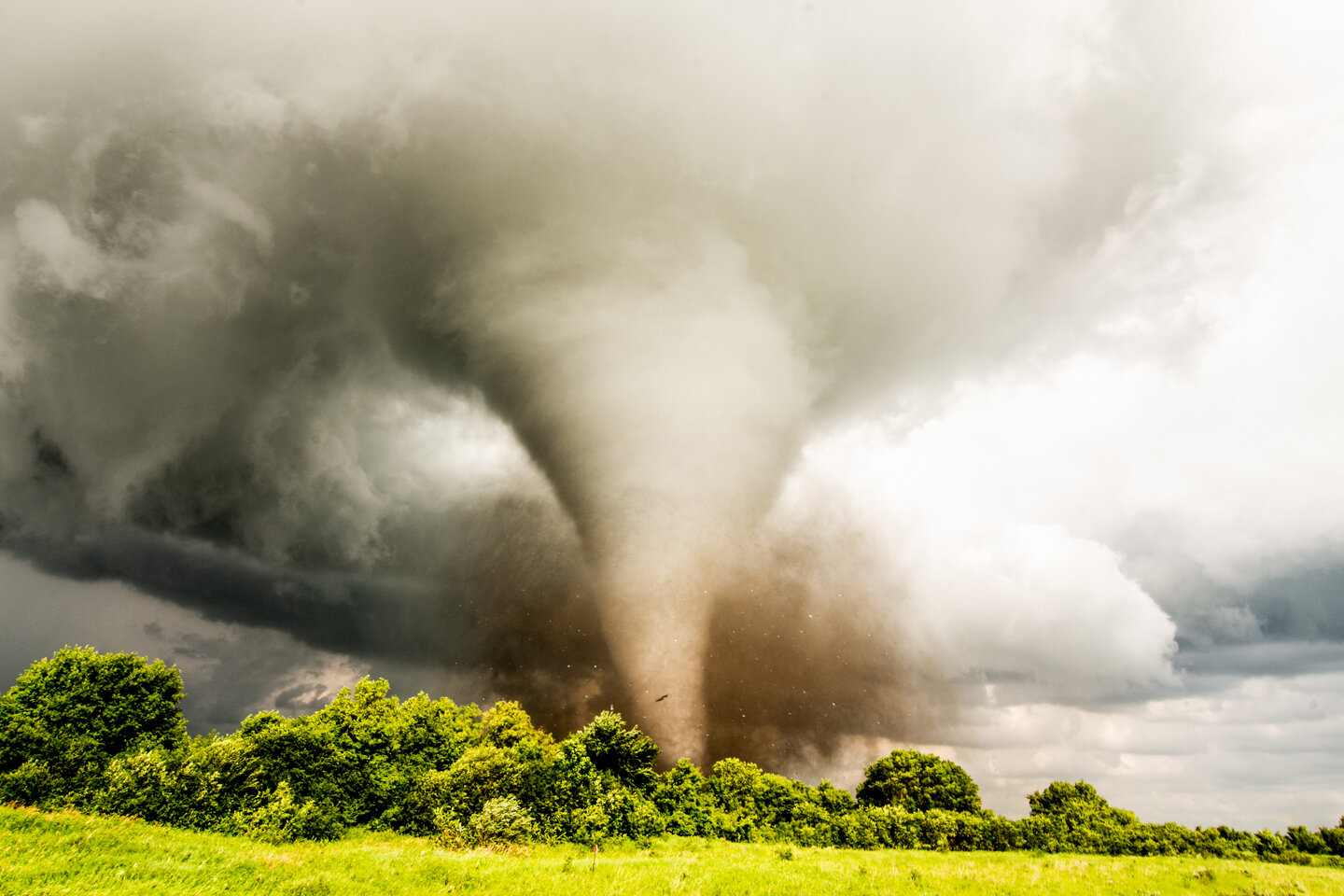
Large pieces of debris being thrown here as the tornado appeared to be fully wrapping up under the parent circulation.
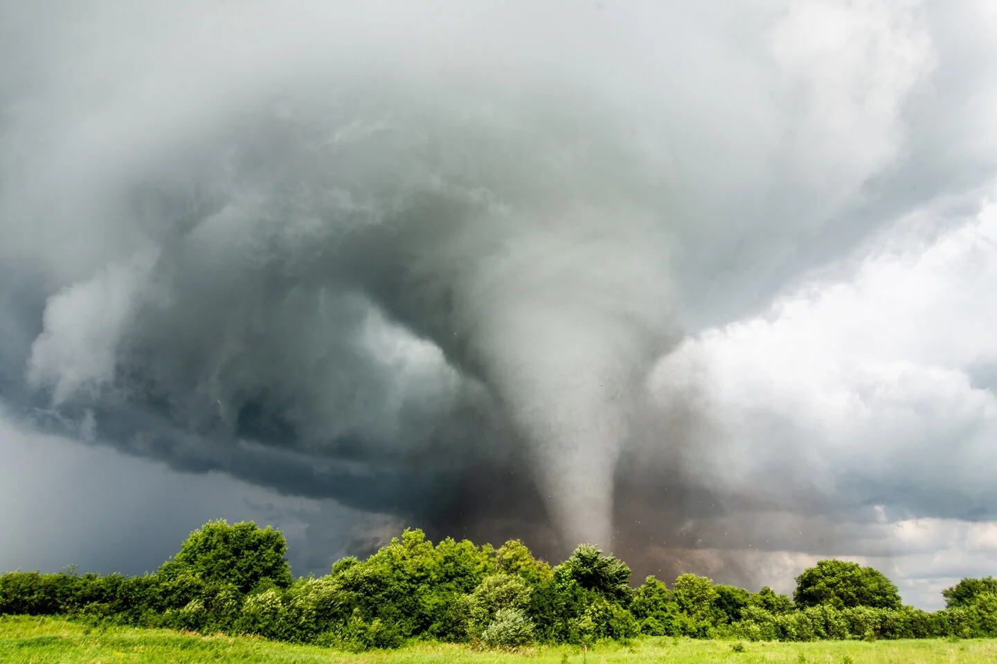
One of my favorite storm chasing photos I have ever taken here. Would be hard-pressed to ever get a shot like this again. This print is blown up large and hanging on my wall! Perfect spot to capture the white tornado with excellent contrast with no precipitation and sun illuminating everything.

Tornado started moving away from us as we watched from a distance while a rainbow forms and points towards the tornado base. Interesting white debris field here.

Beautiful scene with a white tornado in the distance and a rainbow in the foreground. Such an awesome view to behold! This was somewhere north of Ashby, MN as we continued chasing the tornado to the northeast.
Tornado starting to occlude as the storm condensation base erodes but still going strong northwest of Ashby, MN. Terrific contrast and debris cloud with rainbow.

Wall cloud wrapping up with the white tornado in the distance.

Look at the structure!! No rain around the tornado, wall cloud and mesocyclone as you’re able to see the tornado and twisting updraft overhead.

Majestic white tornado starting to rope out between Sewell Lake and Johnson Lake, MN.

Incredible and jaw dropping rope-out at the end of this tornado life cycle!
National Weather Service Review of the EF-4 Tornado: https://www.weather.gov/fgf/2020_07_08_Tornadoes
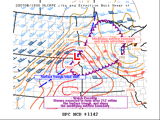
Mesoscale discussion issued at 3:03 PM CDT. Notice the triple point of the low, trough and warm front where our tornadic storm formed just to the east. Storm rode that warm front with the enhanced low level shear and ingested rich boundary layer moisture pooling along the boundary. https://www.spc.noaa.gov/products/md/2020/md1142.html


Mesoscale discussion issued at 6:17 PM CDT as multiple tornadoes have occurred, with our EF4 ongoing with our lone supercell across west-central Minnesota. Storm right on the northern end of the instability axis. https://www.spc.noaa.gov/products/md/2020/md1145.html

Mesoscale discussion issued at 7:58 PM CDT as new storms, a couple that did produce additional tornadoes, were forming along the warm front. https://www.spc.noaa.gov/products/md/2020/md1147.html
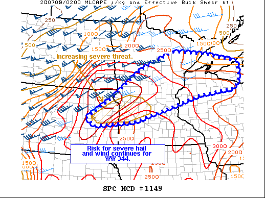
Mesoscale discussion issued at 9:51 PM CDT as the severe weather risk continues as storms congeal. https://www.spc.noaa.gov/products/md/2020/md1149.html
STORM REPORTS:

STORM PREDICTION CENTER OUTLOOKS:

JUNE 28, 2020 MINNESOTA: TORNADO WARNED SUPERCELLS AND A FEW FUNNELS

First supercell of the day, storm base and intense core near Wells, MN.

Intense core as the storm crept closer and right at us near Wells, MN.

Wall cloud organizing on the same storm as we watched directly out ahead.

Organized, rising scud finger that looked like a funnel but was not. However, wall cloud/lowering was rotating at this point.

Rising scud finger still present with the wall cloud becoming more ragged near Austin, MN.

Legit funnel cloud here as we watched the storm near Grand Meadow, MN

Funnel cloud still there in the middle of the wall cloud and easy to identify inflow tail condensating right to left into the action area.

Decent structure here of the storm base of a tornado warned supercell near Spring Valley, MN

Beautiful wall cloud on a tornado warned supercell in the hill country near Preston, MN

Rotating wall cloud on the storm near Preston, MN. Closest this storm came to dropping a tornado through its life cycle!

Mesoscale discussion issued at 3:42 PM CDT for southeast Minnesota and north-central / northeast Iowa. Remnant MCV moving through the area and may produce a few funnels and a brief tornado. https://www.spc.noaa.gov/products/md/2020/md1039.html

Tornado watch issued at 5:15 PM CDT for southeast Minnesota and a couple counties in northeast Iowa. https://www.spc.noaa.gov/products/watch/2020/ww0315.html

Mesoscale discussion issued at 7:20 PM CDT as the severe threat continues. https://www.spc.noaa.gov/products/md/2020/md1044.html
STORM REPORTS:

STORM PREDICTION CENTER OUTLOOKS:

JUNE 8, 2020 NEBRASKA: MEAN TORNADO WARNED SUPERCELL AT DUSK

Mammatus on the northern storm as we were approaching after crossing the dam at the Missouri River near Pickstown, SD.

Approaching from the northeast on the farthest north severe thunderstorm in a broken line through east-central Nebraska. Can see a lowering here where the mature wall cloud is wrapping into the mesocyclone.

Severe warned supercell near Dustin, NE as we were driving south to chase a stronger storm. Terrific structure!

Approaching the stronger supercell to the south near Atkinson, NE. This storm soon becomes tornado warned.

Wall cloud in the notch of this storm on the northern side of the storm base where the mature mesocylone was occluding.

Dual mesocyclones looking to our south towards Atkinson, NE

Another view of the wall cloud trying to tighten up. Inflow tail and fast right to left condensation into the storm at this point. Hard to tell if there’s anything that is touching down in there due to all of the dirt and generally low visibility.

Screaming inflow to our backs into this wall cloud at this time. This is when it looked the most interesting in regards to potentially producing a tornado. Was still tornado warned at this point.

Very interesting. Rapid inflow right to left into this rotating wall cloud. Still can’t see what’s going on in there.

Lots of dirt being pulled into this storm with screaming fast inflow from our backs.

End of the chase during the evening as a strong and intense line of heavy rain and hail as approaching. Looking northwest from near Bristow, NE.

Mesoscale discussion issued at 3:16 PM CDT. 80% chance of watch issuance along and ahead of the stalled boundary from eastern South Dakota into central Nebraska. We were positioned in Mitchell, SD on the northern end of where thunderstorms were expected to develop. https://www.spc.noaa.gov/products/md/2020/md0882.html


Mesoscale discussion issued at 7:16 PM CDT for central Nebraska where a localized tornado threat existed. https://www.spc.noaa.gov/products/md/2020/md0885.html

Mesoscale discussion issued at 9:13 PM CDT as severe storms were moving north along the front into South Dakota. https://www.spc.noaa.gov/products/md/2020/md0887.html
STORM REPORTS:

STORM PREDICTION CENTER OUTLOOKS AND VERIFICATION:


JUNE 7, 2020 MINNESOTA: TORNADO WARNED SUPERCELLS NEAR THE CANADA BORDER

First severe thunderstorm of the day near Karlstad, MN. Heck of a core here!

Decent structure on the storm near Donaldson, MN. Inflow scud condensing on the right side.

Rotating wall cloud wrapping up quickly near Lake Bronson, MN.

Got up close to the wall cloud northeast of Lake Bronson, MN with a nub funnel trying to form in the middle. Very fast condensation right to left into this wall cloud.

Funnel in the middle as the wall cloud tightened up.

Another shot of the funnel becoming more ragged here but the white wall cloud in front of us tightening up.

Tornado warned storm, again near Donaldson, MN at the end of the day. Lots of interesting features/motion underneath this base.

Mesoscale discussion issued at 2:00 pm CDT. 95% chance of a tornado watch being issued. Severe thunderstorms expected to develop with a tornado threat, especially along the warm front. https://www.spc.noaa.gov/products/md/2020/md0869.html

Another mesoscale discussion issued further southwest into South Dakota and northern Nebraska at 2:04 pm CDT. Another watch likely to be issued ahead of the low and trough. https://www.spc.noaa.gov/products/md/2020/md0870.html


Mesoscale discussion issued at 5:55 pm CDT with tornado threat increasing. https://www.spc.noaa.gov/products/md/2020/md0874.html

Mesoscale discussion update issued at 6:00 pm CDT for the severe thunderstorm watch area in South Dakota. Mentions hail and wind being the main threats but notice on the storm reports that all the tornadoes were in this area! https://www.spc.noaa.gov/products/md/2020/md0875.html

Mesoscale discussion issued at 8:42 pm CDT. Image describes what’s going on… starting to merge into a cluster/QLCS while more discrete cells remain in our area we were chasing in far northwest Minnesota. https://www.spc.noaa.gov/products/md/2020/md0877.html