


MAY 24, 2020 KANSAS: VIOLENT, DANGEROUS SUPERCELL AND MICROBURST

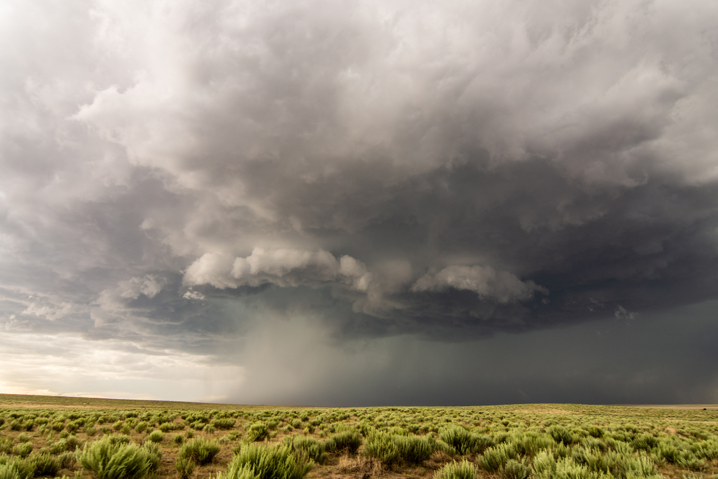
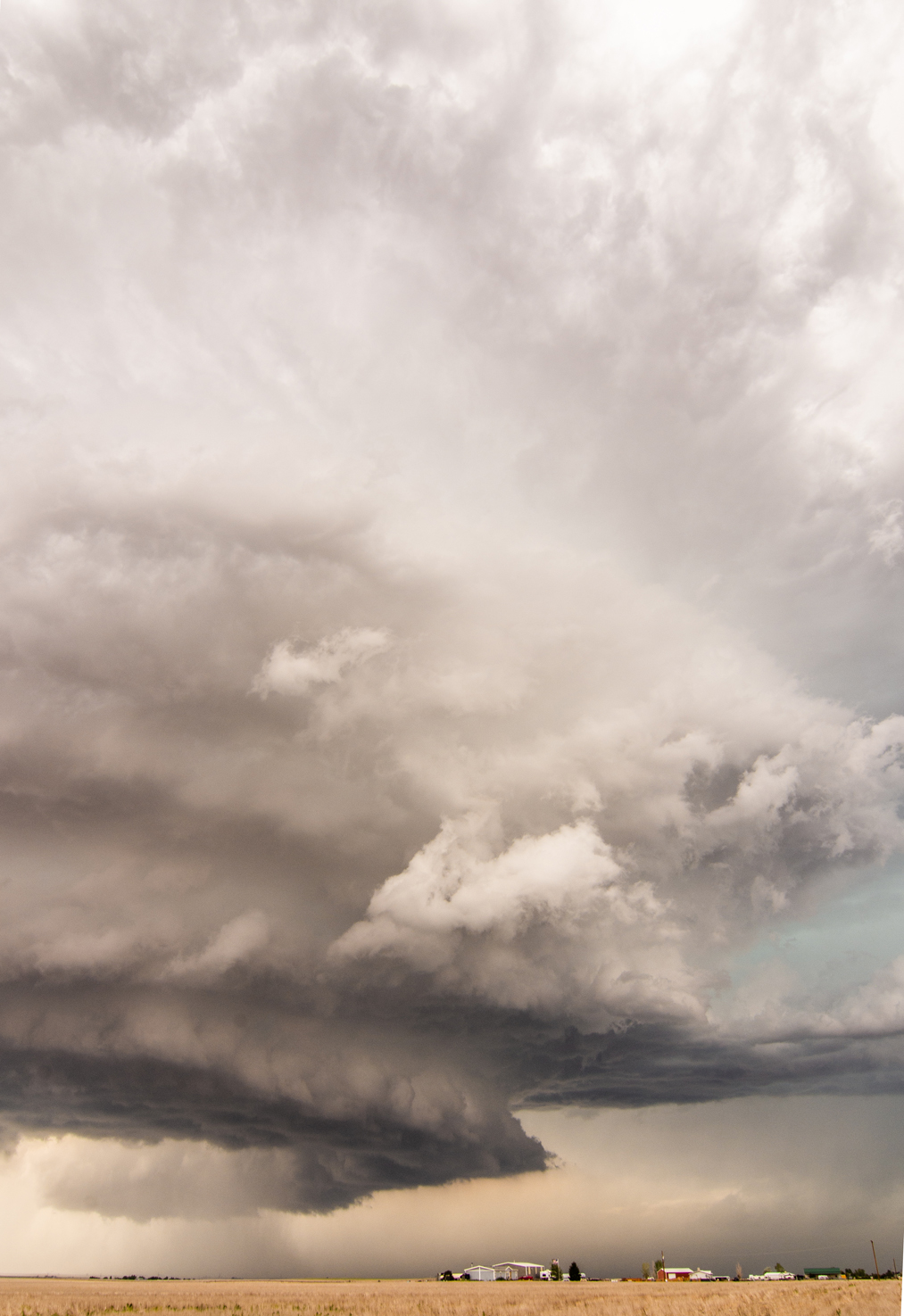
Initial intercept of an intense supercell storm coming out of southeast Colorado. Warned for 70+ mph winds and ping pong ball size hail!

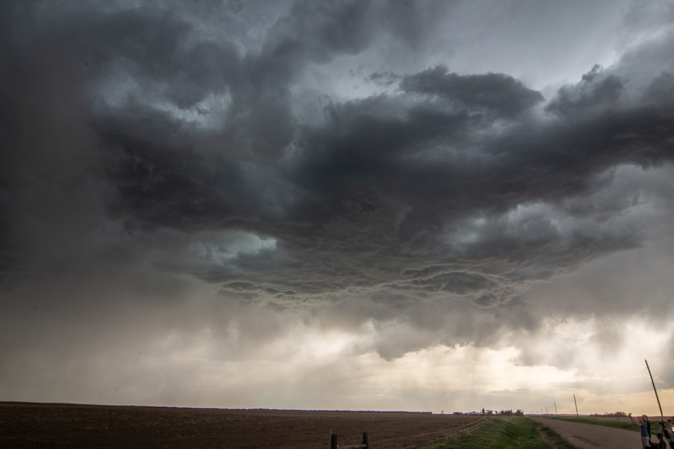
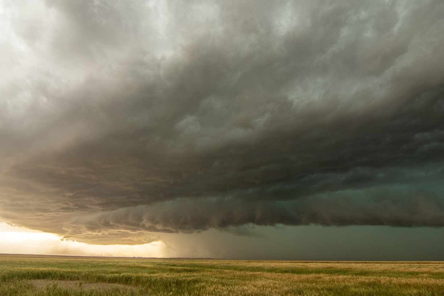
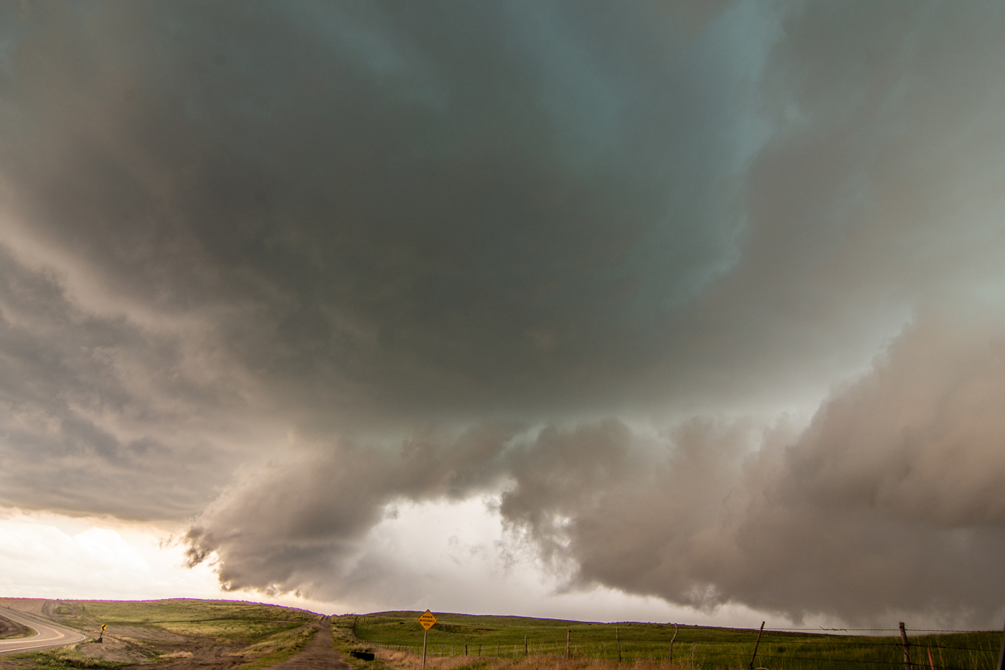
Beautiful structure on this mean looking storm!

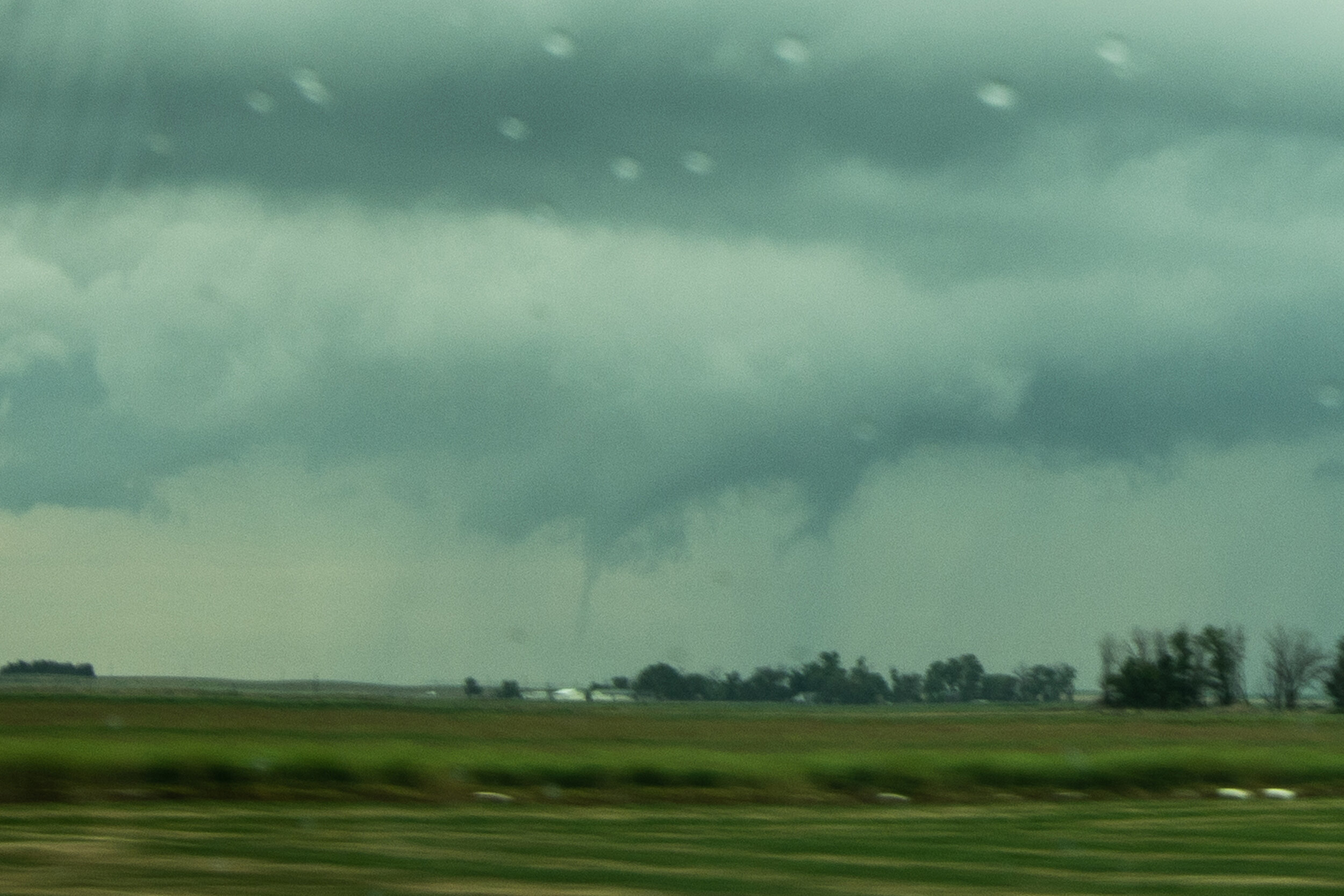
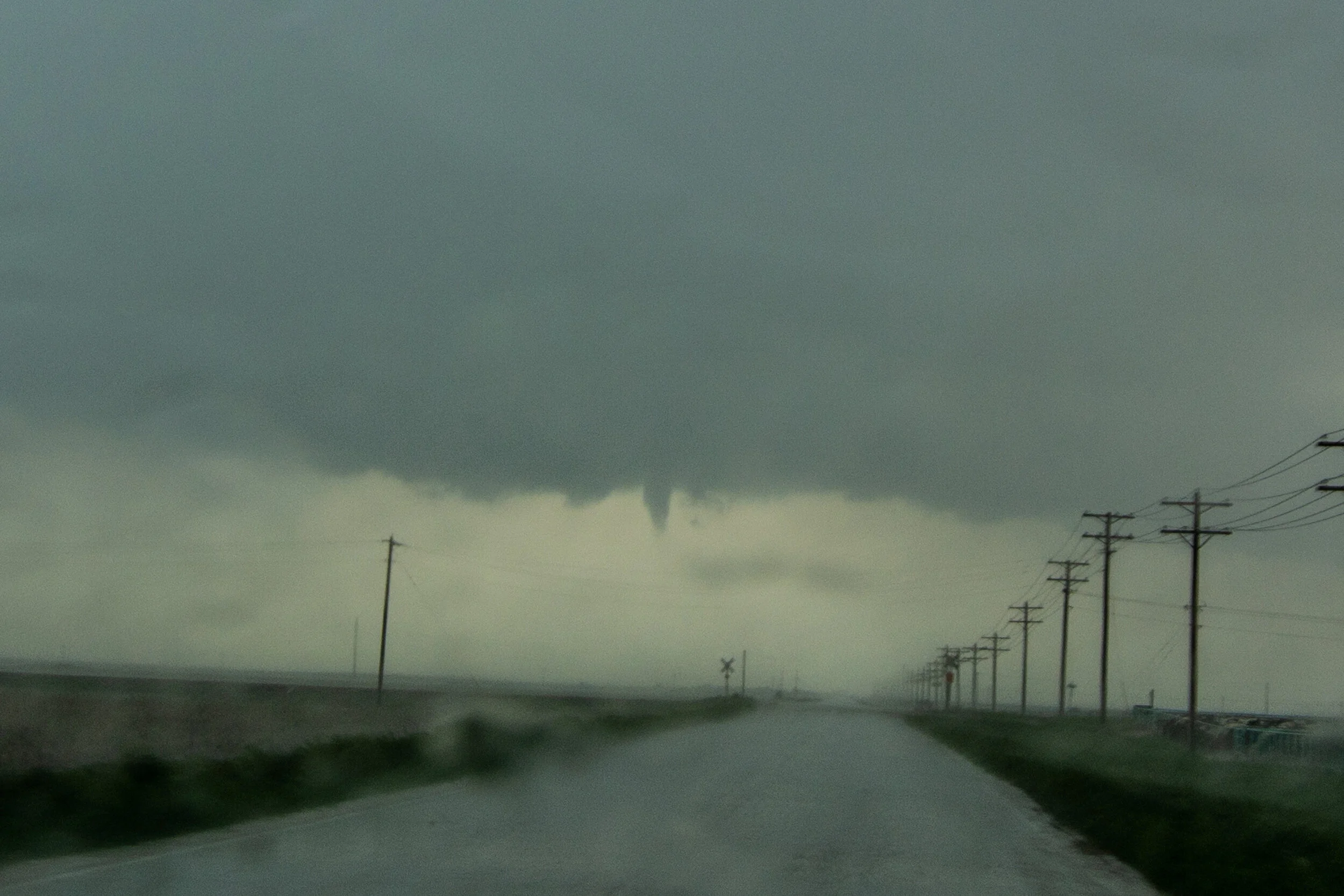
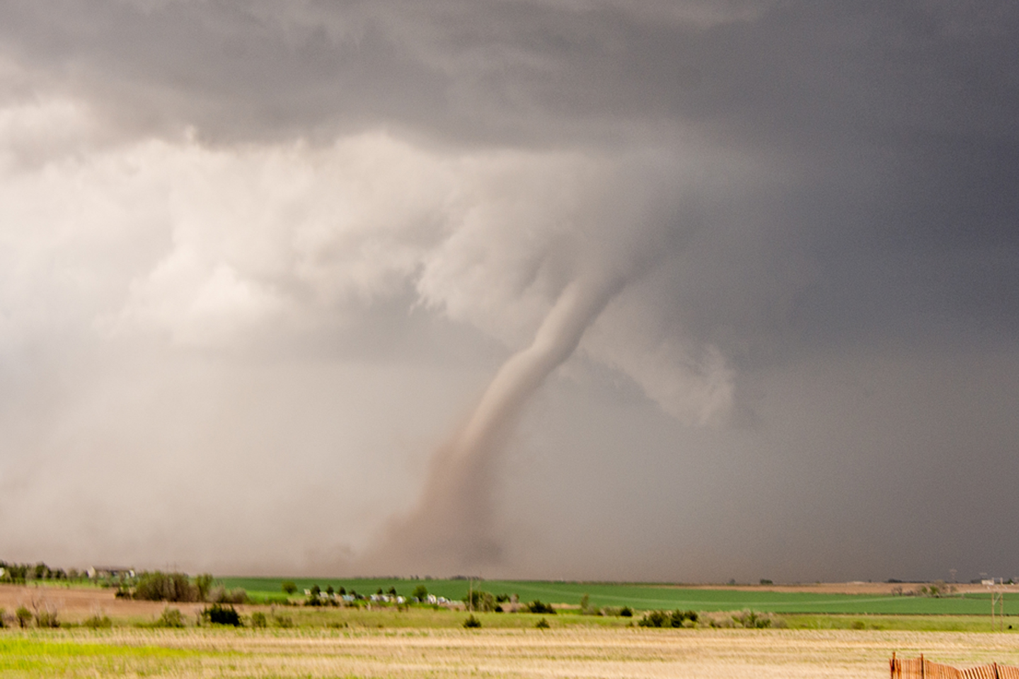
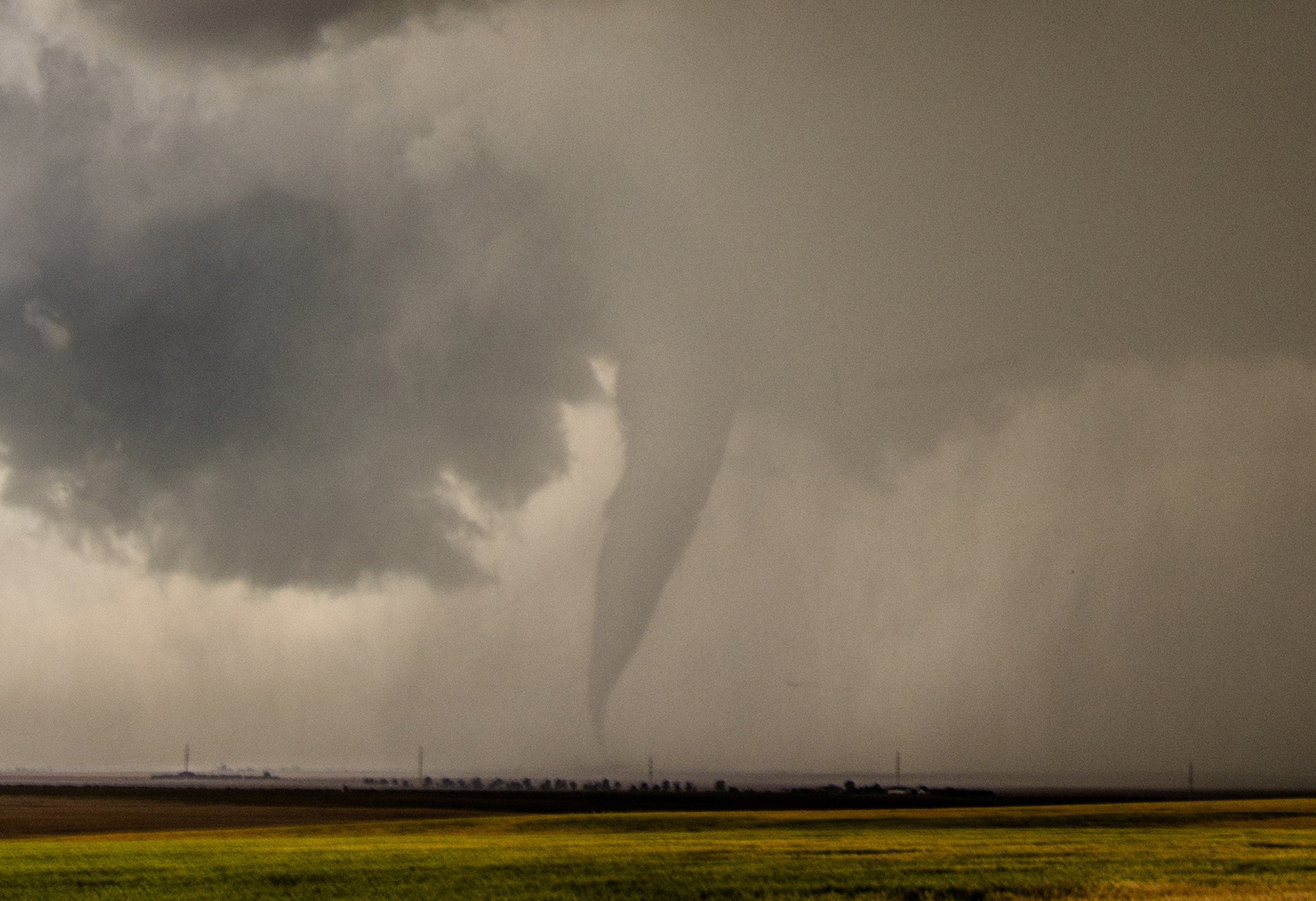
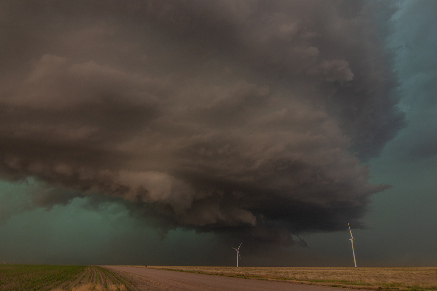
Possible tornado under the updraft base but could easily be concentrated area of rear flank downdraft winds coming around the south side of the mesocyclone.

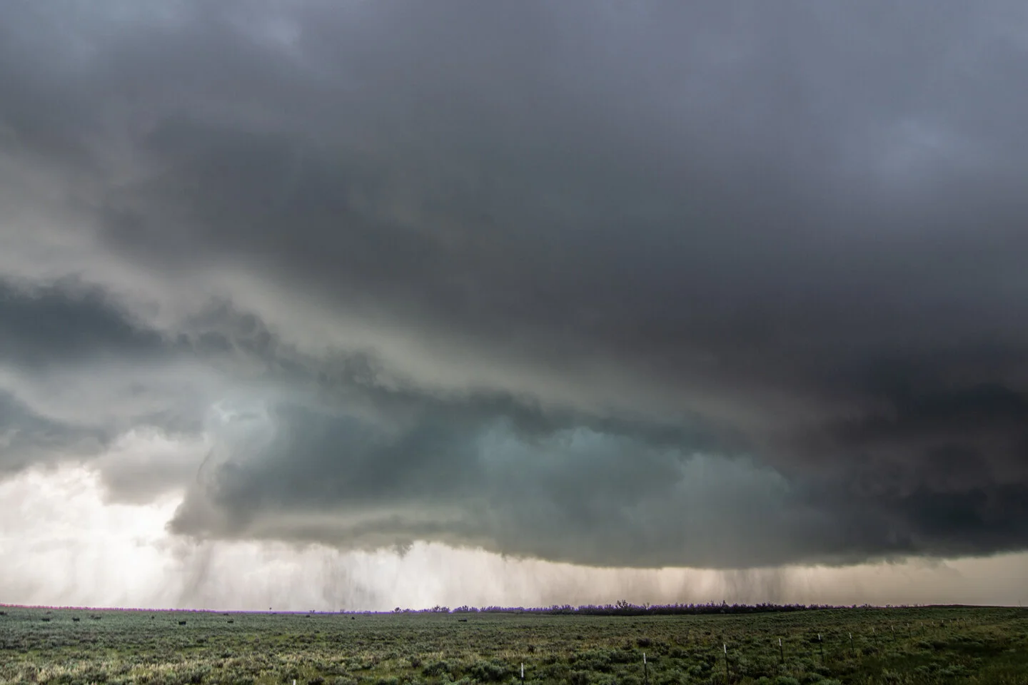
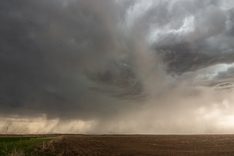
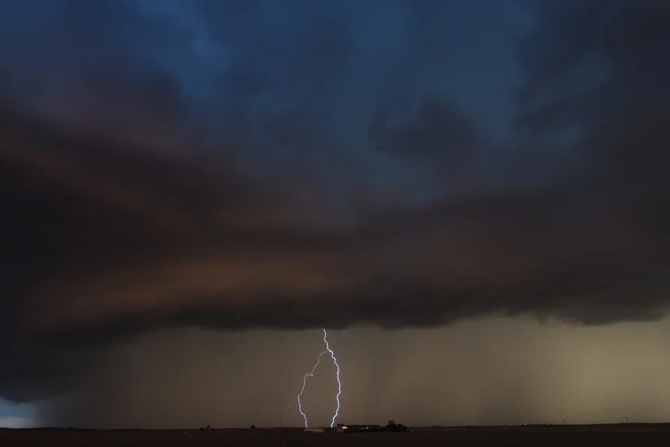
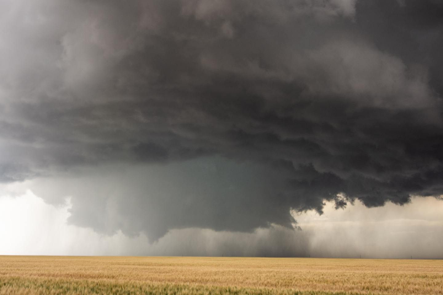
Microburst in the center of the image descending to the ground.

Closer view of the microburst quickly descending. I bet this thing produced nearly 100 mph winds when it hit the ground.

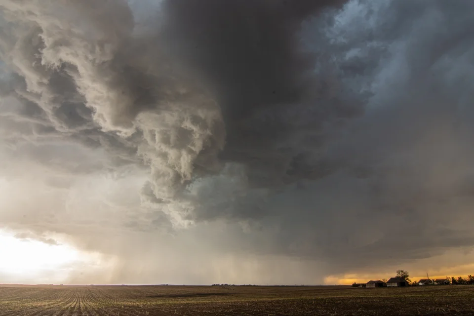
Beautiful storm! Looking northwest towards the forward flank core.

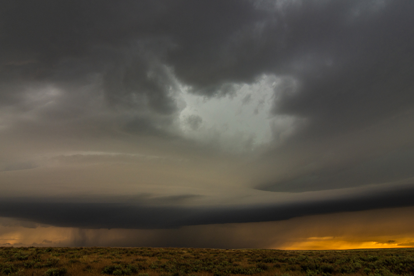
Nature’s vacuum! 50 mph inflow winds to our back being sucked into this storm. Notice all of the dirt being pulled into the updraft region and up into the storm.

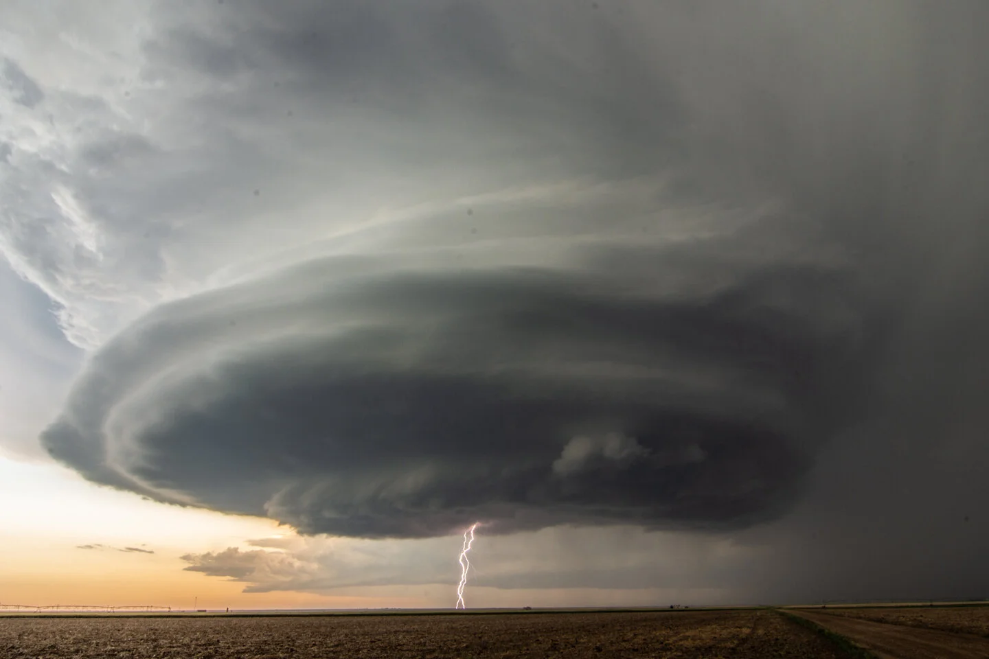
Terrific storm structure near Hugoton, Kansas. WHAT A BEAST


Getting dark later in the evening as the storm rages on near Hugoton, Kansas.


Awesome structure and starting to throw out some lightning!


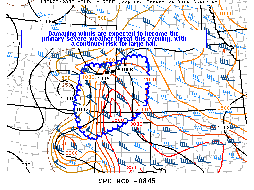
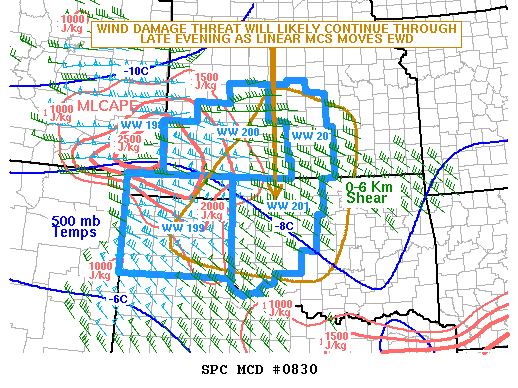
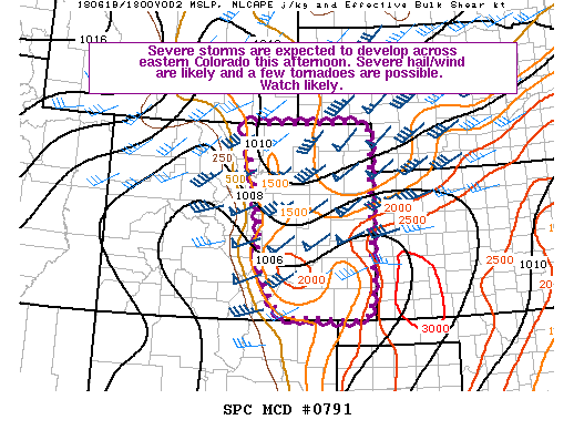
Mesoscale Discussion issued at 2:15 p.m. CDT. We were in Garden City and initially thinking of staying east on these storms but decided to blast west towards the intense storm coming out of Colorado.

Mesoscale Discussion issued at 2:28 p.m. CDT. This area was really drawing our attention as the short range guidance was indicating one intense supercell rolling out of southeast Colorado.

Severe Thunderstorm Watch issued at 3:45 p.m. CDT for the area we were targeting.

Small Mesoscale Discussion issued at 7:06 p.m. CDT for our storm moving into southwest Kansas.
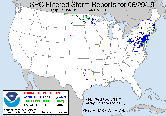
STORM REPORTS:

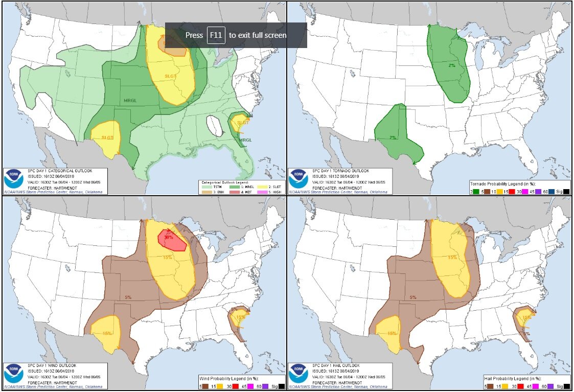
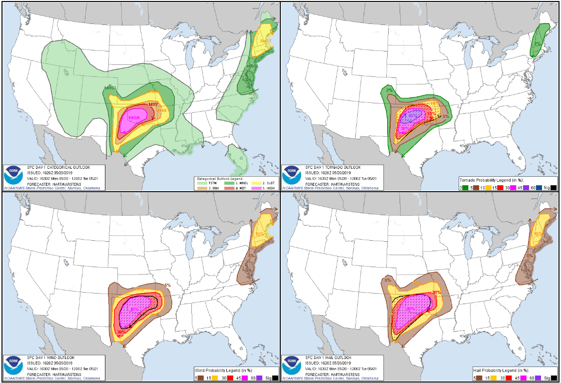
STORM PREDICTION CENTER OUTLOOKS:

MAY 22, 2020 TEXAS: INTENSE SUPERCELL AND 2 BRIEF TORNADOES ALONG THE RED RIVER

Initial updraft of the storm breaking the cap by late afternoon near Haynesville, Texas.

Intensifying storm starting to anvil out, looking above our heads as lightning was becoming more frequent.

Initial wall cloud forming as the storm begins to mature and track east along the Red River between Haynesville and Burkburnett, Texas.

A pair of funnels underneath the updraft.

Tornado warned storm kicking up dirt on the south side of the bowl lowering near Burkburnett, Texas.

Brief tornado underneath bowl funnel. Notice concentrated area of dirt being picked up right in the middle of the picture.
Another shot of the tornado and funnel above that is more noticeable than the previous image. Clear concentrated rotation within this dirt plume.

Concentrated rising scud into the storm base and some structure in this shot, taken near Thornberry, Texas.

Nice structure on this storm as we got further out ahead near Thornberry, Texas.

Another very good structure shot!

Watching this wall cloud attempt to organize near Petrolia, Texas.

Shot of the well organized inflow tails into this storm, right to left, and a wall cloud still intact. Some semblance of a funnel or bowl lowering underneath.

Second brief tornado, noticeable by the debris cloud underneath the funnel and wall cloud near Petrolia, Texas. Lucky to get a view here as this area is hilly with a lot of small trees and brush.

Two wall clouds here, one in the foreground and background. Latter produced the tornado that was shown in the previous photo. Thought the one in front could do the same thing.

One more shot of the matured wall cloud and storm towards the end of the day as it was about to overtake us.

Mesoscale Discussion issued at 12:55 p.m. CDT with expectation of thunderstorm initiation within the next hour. Interestingly enough, thunderstorm initiation occurred much later and closer to 5-6 p.m. as the cap held and initial towers could not sustain.

Mesoscale discussion issued at 1:25 p.m. CDT for developing severe weather threat on northern edge of the highest CAPE axis.

Initial Severe Thunderstorm Watch issued at 1:25 p.m. CDT.

Mesoscale Discussion issued at 6:20 p.m. CDT indicating threat of tornadoes for 1-2 hours with the storm we were on just south of the Red River.

New Severe Thunderstorm Watch issued at 6:55 p.m. CDT.

Mesoscale Discussion issued at 9:26 p.m. CDT for ongoing severe weather threat. We were forced to go east to I-35 and head back north to Oklahoma City to get past the more intense supercells.

Mesoscale Discussion issued at 11:56 p.m. CDT.
STORM REPORTS:

STORM PREDICTION CENTER OUTLOOKS:

MAY 21, 2020 KANSAS: STORM STRUCTURE OF THE YEAR!

Wall cloud starting to organize on the first storm of the day in Holly, Colorado. Soon after became tornado warned.

Storm chasing 2020 COVID-19 style! Wall cloud and funnel look-alike inflow tail in Holly, Colorado. Storm is tornado warned at this point and the sirens were blaring.

Another view of the wall cloud on the tornado warned storm over the southern part of Holly, Colorado.

Nice structure on the storm as it was moving over Holly, Colorado and threatening to overtake us.

The second supercell was even better! Stacked plates and broad meso on the storm near Ulysses, Kansas.

Another shot of the supercell near Ulysses, Kansas.


It just gets better and better! 3rd supercell of the day near Satanta, Kansas. Incredible structure!

Just awesome. Epic storm structure and popping cloud to ground lightning near Satanta, Kansas. What an experience!
Double cloud to ground lightning strikes in one shot… yes please.

Incredible storm continues to amaze.

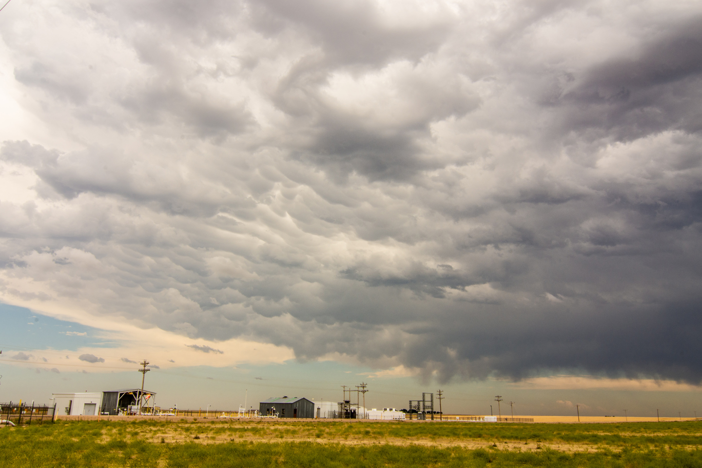
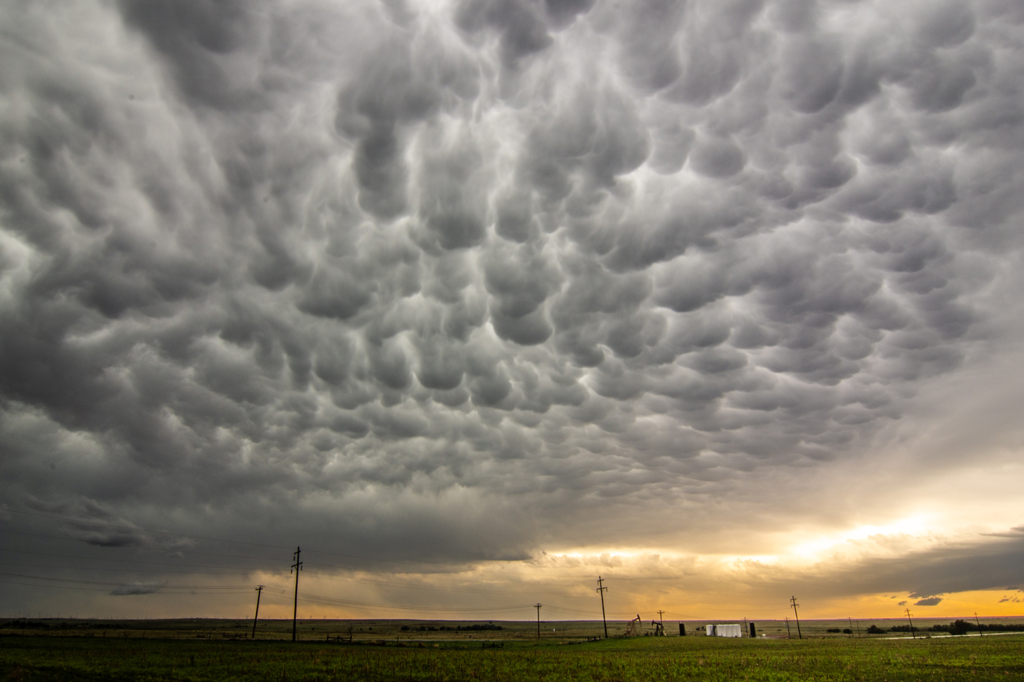
Mammatus and stacked plates on a mothership over the wide-open Plains of southwest Kansas. Can’t be beat.


Funnel cloud emerging on the tornado warned storm near Satanta, Kansas.

Funnel cloud just to the right of the lightning strike nearly touching down.

Funnel cloud still holding together just above the light from the farmhouse in the distance. What a structurefest of a day!

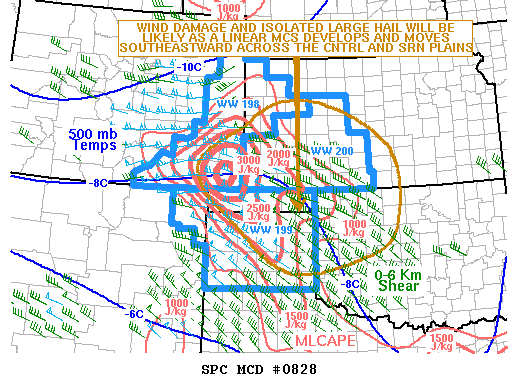
Mesoscale discussion issued at 2:20 p.m. CDT for development of storms within the next few hours and a risk of large hail and damaging winds.

Severe Thunderstorm Watch issued at 3:15 p.m. CDT.

Severe Thunderstorm Watch issued at 9:50 p.m. CDT ahead of the squall line surging southeast into northwest Oklahoma.

Mesoscale discussion issued at 9:10 p.m. CDT indicating the primary severe weather threat for the next few hours.

Mesoscale discussion issued at 11:28 p.m. for the enhanced severe weather threat with the squall line surging southeast.
STORM REPORTS:

STORM PREDICTION CENTER OUTLOOKS:

MAY 20, 2020 WYOMING AND COLORADO: SEVERE STORMS & LIGHTNING SHOW
Had a great day chasing storms in eastern Wyoming and northern Colorado! Best supercell storm of the day was near Keota, Colorado during the evening. This storm put on an incredible lightning show for us. First day guiding for http://www.silverliningtours.com/

Nice cloud to ground strike on our initial storm in southeast Wyoming. I think this was on the storm near Chugwater.

Tough to see but another CG out of our initial storm of the day near Chugwater, WY. Turbulent skies.

Taking shots of the storm.

CG’s out of the storm and a couple of separate storm bases near Keota, CO.

Another arcing CG lightning strike out of the storm as we positioned out ahead near Keota, CO.

Watching the storms and taking shots at sunset.

Beautiful lightning near Keota, Colorado. All following lightning shots are from near Keota. Awesome display after sunset during the evening.


STORM REPORTS:

STORM PREDICTION CENTER OUTLOOKS:


JULY 1, 2019 MINNESOTA: LONG-LIVED TORNADO WARNED STORM AND SEVERAL FUNNELS

Beautiful tornado warned storm near Clarks Grove, Minnesota. Well defined inflow (beaver) tail into the storm at the base of the updraft.

Wall cloud better defined on the storm just east of Clarks Grove, Minnesota. Lots of rotation and rising motion into the wall cloud at this point. I thought it was going to produce a tornado right in front of us.

Another shot of the merry-go-round portion of the wall cloud and solid inflow as noted by the tail on the right. If you watch the video, you can really see the strong rotation.

Funnel cloud forming on the left side of the wall cloud just east of Clarks Grove, Minnesota.

Nice clear slot punching in on the left side of the wall cloud as the downdraft and inflow combination was becoming better aligned. This is a classic look before a storm produces a tornado, which it did a short while later in Hollandale.

Another funnel tightening up nearly right overhead near Hollandale, Minnesota.

Yet another funnel cloud forming near Lansing, Minnesota. This was around 5 miles south of my hometown of Blooming Prairie. Notice the well defined clear slot on the back edge of the wall cloud on the left…textbook.

Another funnel cloud (right in the middle of the photo) looking to the east from near Lansing, Minnesota.

Looking directly up at the storm updraft towering to the heavens.

Wall cloud and inflow tail still going strong as the supercell continues to cycle near Waltham, Minnesota.

Last wall cloud of the day before we bailed and headed home. This was east of Sargeant, Minnesota.
STORM REPORTS:

STORM PREDICTION CENTER OUTLOOKS:

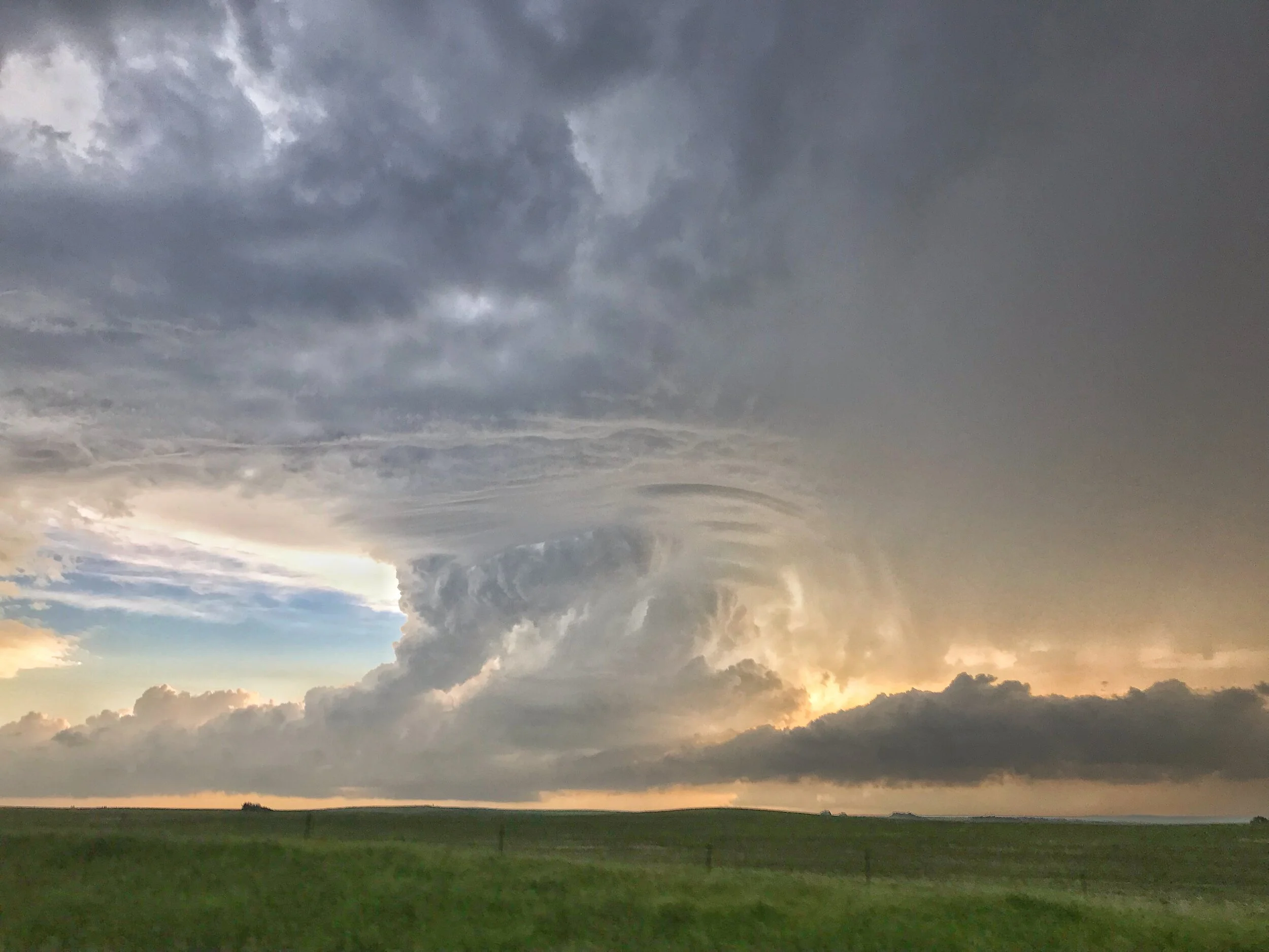
JUNE 29, 2019 NORTH DAKOTA: AWESOME STRUCTURE ON TORNADO WARNED STORM

Finally about to intercept a tornado warned supercell that had already been raging for the past few hours in central North Dakota. This is looking southwest from near St. Anthony, North Dakota.

Terrific structure on this storm with multiple inflow bands and crisp, rock hard updraft looking southwest near Flasher, North Dakota.

Absolutely jaw dropping storm structure!

Some of the best storm structure of the year for me here! Awesome site to the twisting and turning storm updraft.
Edited iPhone shot.

Incredibly, the storm went from looking amazing to completely dying within 10 minutes. I’ve never seen a tornado warned storm that looked so great die off this fast.
STORM REPORTS:
STORM PREDICTION CENTER OUTLOOKS:

JUNE 4, 2019: MINNESOTA SEVERE STORMS AND SHELF CLOUD

Shelf cloud approaching, looking west from near Lonsdale, Minnesota. Nice easy drive from my house to intercept this severe warned storm!

The storm definitely still had some inflow on the right side where the gust front butted up against the forward flank core, as indicated by the notch as well as winds into the storm at my position.


Shelf cloud about to overtake me!

Awesome undulatus asperatus display as the storms moved over our house in Farmington!

STORM REPORTS:

STORM PREDICTION CENTER OUTLOOKS:
MAY 26, 2019: BRIEF TORNADO NEAR WILEY, CO; FUNNELS, SUPERCELLS AND HAIL

Nice looking view of our first storm of the day and the open landscape of eastern Colorado near Lamar. I like the wavy look to the clouds and the virga as the atmosphere was moistening up during the early afternoon.
Confirmed tornado near Wiley, Colorado! The first storm we intercepted produced this tornado quickly as it interacted with the warm front.

The same tornado as above starting to lift and rope out at this point.

Tornado roping out north of Wiley, Colorado.

Another low funnel that may have touched down but not confirmed to the north of Big Bend, Colorado. This was the same storm that produced the tornado earlier.

Our second tornado warned supercell of the day with a beautiful wall cloud developing to the south of Lubers, Colorado. Lots of chasers on this storm!

Wall cloud tightening up to our west near Lubers, Colorado.

This was the closest that this storm came to producing a tornado as the rotating wall cloud really tightened up here just to our west.

Driving north towards Eads, Colorado the storm had a very low-hanging wall cloud that could have easily produced.

Larger view of the wall cloud to our north as we drove on highway 287 towards Eads, Colorado.

Caught up to the storm near Eads, Colorado and were able to drive right up to the rotating wall cloud.

After driving through the forward flank hail core, we passed to the north of a beautifully structured wall cloud just to the east of Eads on highway 96. This was one of, if not the best wall cloud that I saw all year in 2019!
We got a little further east of the wall cloud towards Chivington, Colorado and continued to view the rotating wall cloud and rain curtains wrapping around the hook of this tornado warned storm.

Tight wall cloud/funnel just to our south near Brandon, Colorado. Nearly produced a tornado!

One wall cloud in the foreground and you can see another wall cloud wrapped in rain in the distance near Sheridan Lake, Colorado.

End of the day and chase near Sheridan Lake, Colorado as the storm was starting to become outflow dominant as noted by the shelf cloud. Thereafter, we began the long all night drive back to Minnesota. Well worth sticking around an extra day for this chase!
STORM REPORTS:

STORM PREDICTION CENTER OUTLOOKS:

MAY 25, 2019: FUNNEL CHASE ALONG THE COLORADO, OKLAHOMA, KANSAS BORDER

Cell phone shot of a lightning strike on our initial storm near Dumas, Texas.

Rotating wall cloud and scud fingers rising up into the base with several inflow bands right to left near Sturgis, Colorado.

Beautiful storm in Johnson City, Kansas, approaching from the southwest. Big hail core about to overtake us before we quickly got out of there.
Funnel cloud south of Johnson City, Kansas. Was quite persistent and a bit of a surprise being on the storm coming up from our south and not our initial storm we were on!

Another shot of the funnel cloud as we were flying south of Johnson City, Kansas trying to get a closer look.

Looking west from Big Bow, Kansas at another storm dropping a lowering and interesting rising scud underneath the main updraft on the tail end storm. Never did anything but this was interesting to see at this point!
STORM REPORTS:

STORM PREDICTION CENTER OUTLOOKS:

MAY 22, 2019: 3 TORNADOES IN EASTERN OKLAHOMA

Tornado #1 forming west of Okmulgee, OK. Notice the horizontal funnel at the cloud base to the right of the wall cloud!

Another shot of the tornado forming west of Okmulgee, OK. Lots of motion and rotation here as you can see in the video above.

Tornado #2 looking directly west from an overpass in Okmulgee, OK. This tornado appeared to be more substantial and longer lasting than the first.

Wider shot of the tornado moving left to right, directly west of Okmulgee, OK.

Roger Hill and the Silver Lining Tours gang taking in a rapidly rotating wall cloud that is approaching our position.

Merry Go Round wall cloud currently dropping a few vortices on the road in front of us. Tornado #3!

Closer, cropped photo of one of the vortices spinning up under the wall cloud right in front of us. An amazing site!
STORM REPORTS:

STORM PREDICTIONS CENTER OUTLOOKS:

CHASE LOG, PROVIDED BY RICH HAMEL:
Day 9: May 22nd, 2019
Yet another day with big possibilities as moisture poured into Oklahoma with 70-degree dewpoints along a frontal boundary stretching from about Wichita Falls, TX to Joplin, MO and beyond. The models put the best sheer profiles in the area of Tulsa, OK so we started making our way down there from Salina, KS, intending to stop in Bartlesville, OK.
We proceeded down south of Wichita on I-135, stopping for a rest break just north of the Oklahoma border. Once there, analyzing the road flooding situation on the Oklahoma DPW website, we realized we had a problem: there was no way to get to Bartlesville from where we were as all of the roads were flooded out! Because of that we adjusted our target to Tulsa and continued south, and then east on Rt. 412 all the way to Tulsa where we stopped for lunch and waited for storms to initiate.
We stayed in Tulsa for about an hour and a half as storms began to initiate to our south and grow in intensity. Soon there were multiple severe storms to our south showing signs of rotation and we headed south to intercept. We headed south on Rt. 75 intending to get to Beggs and wait for our target storm to come to us, but as we closed in the storm went tornado warned and there were tornado sightings so we sped down to Okmulgee with a west option that would allow us to drive right up to the updraft. We made it through Okmulgee and headed west on Rt. 56 into the woods around Okmulgee Lake in heavy rain as we skirted the front-flank core. As we blasted west past Nuyaka and got around the precipitation core, the big, beefy updraft became visible and it was clear we were going to meet it right on the road to our west. After the road made a dogleg south, we turned west again and were driving right towards the ground scraping wall cloud just to our west. As we closed further, in the distance through the woods a dark mass crossed the road about 2 miles west of us. Tornado! We drove right up to where it had crossed the road and there it was in the woods just north of us, a multi-vortex tornado slowly meandering away to the north, shifting from multi-vortex with tendrils skipping along the ground to a brief cone with more complete condensation. We observed the tornado for about 5 minutes and then decided we needed to get east and north to keep up. We blasted east then north up Dentonville Rd. towards Nuyaka, with the wall cloud to our northwest. But we were running out of road and not closing the distance much, when it became clear that the next storm to our south behind this one was interfering with our target storm and also taking over the show. We broke off and turned back south to Rt. 56.
When we got to Rt. 56 and turned east, it became clear that we had to get east to Okmulgee in a hurry because the meso-cyclone of our new, tornado-warned target was going to get there at just about the same time we were! I did some quick calculations as the lead van had lost radar and decided we would make it with just a few minutes to spare. We flew east in the rain and when we got to the outskirts of Okmulgee, we navigated around the perimeter of town by heading south on S. Madison Avenue, then East on E0970 road and finally turning south on Rt. 62. Almost immediately upon making the turn south, the road went up a hill providing a good vantage point, and off to our west was a large cone tornado traveling through the woods. Tornado #2! about 30 minutes after the first one on the previous storm. This one had formed on the occluded meso of our new target storm and as we watched it to our northwest, the new meso to our southwest looked like it might tornado at any time as well, and soon produced a big funnel as the cone tornado faded off into the rain to our north.
We had to get back north to prevent ourselves getting cut off by the storm so we turned around again, going north, then east out of Okmulgee on Rt. 62 towards Morris with the meso coming right up behind us. Just west of Morris we pulled over and observed as the rapidly rotating wall cloud crossed the road only a mile or so behind us. As it crossed the road several brief suction vortices appeared skirting across the ground towards cloud base, tornado #3! After this brief tornado lifted, we headed into Morris and then north on Rt. 52 and drove right up to the mesocyclone as it headed north-northeast right in front of is. It had clearly lost some focus though and a new tornado was not yet imminent so we followed north, then turned east briefly on E0940 Road to get a view, but saw that he wall cloud was disorganized, so we got back on Rt. 52 north then turned east on Rt.16 as we continued stair-stepping.
The storm was moving rapidly away from us to the northeast as we reached the junction of Rt. 16 and Rt. 64 and off to the northeast we saw a white elephant trunk tornado in the distance. Tornado #4 of the day! This one was pretty far distant though and moving away. We continued east into Muskogee and north on Rt. 69 but it was clear we weren’t going to catch the storm.
Being behind the storms without much opportunity to catch up and having had our fill, we called off the chase and turned south back to I-40, keeping an eye on storms to the south of OKC in case they should become worth chasing. They never did, though a severe storm did hover about an hour west of our hotel most of the night. We eventually ended the chase and headed to OKC to spend the night.
Miles for the day were 555.1 for a trip total of 3627.3
MAY 20, 2019: PADUCAH, TEXAS TORNADO

Storm structure shot with well established wall cloud and funnel cloud forming on the left side.

Cannot confirm this was a tornado due to the condensation funnel not clearly reaching the ground, but it sure tried! Persistent, long funnel for several minutes. First attempt on the first storm of the day.

Confirmed tornado! View of the storm, wall cloud, and tornado underneath. This was around 5-10 minutes after the first funnel dissipated.

Closer shot of the tornado just northeast of Paducah, Texas.

Tornado lifting on the left to a needle funnel at this point. Rising scud into center/right side of wall cloud suggests new tornado will be possible after the first occludes.

Wicked shelf cloud approaching near Silverton, Texas.

A view of the shelf cloud near Silverton, Texas as we attempted to stay out ahead.
STORM REPORTS:

STORM PREDICTION CENTER OUTLOOKS:
CHASE LOG, PROVIDED BY RICH HAMEL:
Day 7: May 20th, 2019
A high-risk day for the eastern Texas Panhandle and western Oklahoma! Forecast conditions for this day: dew points in the 70’s, CAPE in the 3000-5000 J/kg range, and strong shear had tornadoes written all over it, at least as long as the storms could remain isolated. That was the main concern as the day also came with a weak capping inversion, meaning the storms might not remain isolated for long. The forecast and target area also suggested that the chaser hordes would be out in force. Our plan was to head southwest out of Oklahoma City and play with the initial storms in the warm sector first before they congealed into a line, then head further southwest to the dry line where we expected the biggest, meanest storms to be later on. The hope was also that most of the hordes would stick with the warm front storms as they put OKC under the gun toward evening. It was an ominous forecast: Some schools in the OKC area were closed in anticipation of a major severe weather event.
We departed OKC and headed southwest to Lawton, then west through Altus, heading for our target Childress, TX where we would stop and adjust accordingly. At Altus AFB, they were getting ready, with all the big military planes on the taxi line revved up and ready to get out of harm’s way. Arriving in Childress, the chaser hordes were already there, and we hung out for some time at a Pilot in town with dozens of other chasers waiting for the warm sector to initiate.
After waiting almost two hours in Childress, storms began firing and soon our attention was drawn to a storm heading up from the southwest towards Paducah, so we headed south on Rt. 62 to intercept. But, as we got close to town just minutes ahead of the rotating area of the storm, we ran into construction and were stopped in our tracks waiting for a lead car to return and take us into town. Seeing that we were not go going to beat the storm into town and get to our east option to stay with the storm because of the construction, we headed east on FTM 314 through the mud then south on FTM 301 trying to get back to pavement.
As we got to the junction of the paved FTM 2876, we could observe the wall cloud of our storm just to the west, and soon, tornado! The storm produced a slender elephant trunk tornado hanging off the back of the wall cloud, fully condensed to the ground. The tornado lasted about 7 minutes before roping out into a long-arced needle funnel.
We headed northeast on FTM 2876 and FTM 104 to stay with the storm, which looked to by cycling to our west. After some maneuvering through Kirkland about 30 minutes later, we head briefly west on Rt. 287 and pulled off in the mud near some railroad tracks as the old occluded mesocyclone passed by, and waiting for the new meso to catch back up to us. Once the precipitation core cleared and the mesocyclone passed it was clear the storm had turn HP, but still had a rock-solid updraft as it passed us by.
As the storm passed just to our west, we were faced with a decision: Follow the storm northeast and cross the river back into Oklahoma and thus give up the dry line play, or let the storm go and head back west to set up for the dry line storms that were already firing. We chose the latter and later found out that our storm had produced a strong tornado near Mangum, OK a bit later. Apparently however the chase had been hindered by an enormous line of chase vehicle traffic, so it is unclear if we could have actually gotten to it. We headed back into Childress and stopped back at the same Pilot gas station and waited again, passing through flash-flooded roads caused by the front-flank precipitation core of our previous target storm as it passed through.
After a fairly short pause in Childress, we had a number of cells to choose from as the dryline was now firing, but unfortunately the worst-case scenario was developing: With no cap, too many storms were initiating and they were all interfering with each other and starting to line out. Examining the storms coming towards us we elected to target a storm showing rotation and still somewhat isolated to our northwest heading for Estelline. We headed through Estelline and west out of town a few miles on Rt. 86, but the storm was a big HP mess, burping out a big shelf cloud as it approached from our west.
At this point, things were looking grim for our chase as the storms were becoming more or less a solid line. Close to giving up, we targeted an HP supercell that was embedded in the line coming up from the south. We passed through Childress again, then Paducah on Rt. 83, and headed west on FM 193 to get towards the inflow notch and area of rotation. Passing through Dumont, we continued a few miles further before determining that the storm was right turning and threatening to cut us off. We blasted back east then south towards Guthrie, passing the area of rotation to our west just north of town. Parked along Rt. 83, it was clear there was a tornado embedded in the big core to our west as the sirens went off in town, but there was no way we were ever going to see it so we had to continue south to get out of the way. We made it as far south as FM 448, waiting for the last storm in the line to meet us, but by the time it got to us it had weakened greatly. After waiting and throwing the football around for a while, we gave up and headed east on Rt. 82 and Rt. 277 to our hotel in Wichita Falls, TX for the evening.
The excitement wasn’t <quite> over yet though since as we settled into our rooms there were not one but two tornadic supercells heading almost directly for the hotel about 2 hours away. But after keeping an eye on them for a while it became clear that they would pass north of town and it was off to bed to get ready for the next day. Somewhat of a High risk bust, though there were tornadic storms chugging away through the night keeping just about the whole state of Oklahoma on alert.
Miles for the day were 558.7 for a trip total of 2453.8
MAY 17, 2019: MCCOOK, NEBRASKA TORNADO AND CHASE

First storm of the day developing west of Wallace, Nebraska. Beautiful chase country out here!

Wall cloud developing as storm base lowers just north of Herndon, Kansas. Starting to get excited about our possibilities at this point!

Wall cloud still getting organized just north of Herndon, Kansas near the KS/NE border.

Twin funnels! Shortly after the last photo between Herndon, Kansas and Culbertson, Nebraska.

After the twin funnels, the wall cloud remained as we traveled northeast on dirt roads to the southwest of McCook, Nebraska.

Another funnel southwest of McCook, Nebraska as we stair-stepped up to the northeast and followed closely.
Beautiful tornado looking west from McCook, Nebraska! Impressive dirt plume.

Wide shot of the tornado outside of McCook. What a beauty! Wizard of Oz type tornado.

Even wider shot of the whole storm and tornado. Notice that impressive and textbook clear slot to the left of the tornado with the eroded cloud base.

Awesome tightening up and rapidly rotation wall cloud near Farnam, Nebraska. We drove right up to this thing but it did not produce.
STORM PREDICTION CENTER OUTLOOKS:

STORM REPORTS:

CHASE LOG, PROVIDED BY RICH HAMEL
A great chase day rewarded by 2 tornadoes (some saw 3) and some adrenaline pumping close encounters! We started the day in North Platte with a general target northeast of the triple point near McCook, NE, with the intent to also keep an eye on storms forming further west along the Nebraska / Colorado border, or potentially needing to drop even further south into Kansas. We initially headed south on Rt. 83 down to McCook, but as storms were already firing west of us, we almost immediately turned around and headed back up to Wellfleet, west on Rt. 20 to Wallace, and then south on Rt. 25. We then stopped about 10 miles south of Wallace to consider our options: there were robust storms to the west coming off the Cheyenne Ridge, but we were concerned they would be high based. Meanwhile to our south there was a storm coming up from Goodland, KS struggling in bad air, but quickly moving into a far better environment. We ultimately decided to target that storm and headed south.
We proceeded down through Hayes Center, then east on Rt. 6 and south at Culbertson onto Rt. 17. As we closed on the Kansas border, the rock-hard eastern wall of the updraft of our rapidly intensifying storm became visible and we knew we’d made the correct choice of storms. We ended up stopping about 2.5 miles from the Kansas border just north of Rt. 704 and could see scud rising into the base of our storm, but as yet it was still fairly disorganized. We stayed with the storm moving back up Rt. 17 and turning off on Rt. 710 to stop and observe again. At this point the storm had a much more defined wall cloud and produced two decent funnels and showed intensifying rotation as the storm got close to us. The storm began to get the look that it could tornado at any time, but soon we were forced to move or risk being cut off by the hail core packing 2-3” hail, so we scooted north to stay ahead. We headed back up 17 and then east on Rt. 713 which unfortunately was dirt, watching behind us as the wall cloud showed more and more rotation. With the storm moving quickly northeast, we blasted east on the dirt road and then north on road 384 and thankfully back onto the pavement into McCook.
As we got to McCook, the tornado sirens were blaring and we decided to head north for a mile or two on Rt. 83 out of town to get a look before heading east. As soon as we turned north, we spotted a large dirt plume, RFD, and then north of that another… with a large funnel extending downward. Tornado! We quickly turned into a nice, empty parking lot near Heritage Hills Golf Course with a clear view to the west and observed the large tilted “Wizard of Oz” tornado churning up dirt about 3 miles west of town. The big white tornado moved northward with a large, dirty debris fan for several minutes, then roped out with a large kink and elongated funnel that stayed in one spot churning as the funnel stretched more and more northward before finally dissipating. We knew the storm was not done yet but now had some catching up to do so we beat feet east!
We now had considerable maneuvering to do in the very poor road network of southwest Nebraska and it would be nearly an hour before we were back in position. We blasted east on Rt. 6 almost all the way to Cambridge, temporarily losing our view of the wall cloud, then turned north on the paved Rt. 73A. We eventually intersected with Rt. 18 to head east…. Only to find that it was not paved!! This slowed our progress dramatically. We slugged our way east about 3.5 miles before turning north onto another dirt road heading towards Eustis. Around this time as we were about 5.5 miles SW of town, we were seeing more tornado reports and heard word of a dusty cone tornado in progress. Our view to the west, when we could see going up and down through little ravines, was of the old meso deteriorating and the new one with a large amount of dirt flying but no clear view of the tornado if it was still there (some guests said they could see it, and later I did see a picture one had taken that made it pretty clear. I did not). Continuing onwards, we descended into a gully, only to hear of another tornado in progress! We quickly turned up a side road and saw an elephant trunk tornado in the distance in the process of roping out for tornado #2 of the day! It only persisted for a minute or two then we were back to our trek in the dirt.
We finally made it to Eustis and back on pavement and quickly blasted west right towards the meso and met it just as it crossed Rt. 23 near Farnam. The wall cloud was spinning like crazy and it appeared that the storm might drop a tornado right in front of it but it never quite focused. We waited until the meso started to fade from view and then blasted east again to keep up. Later, there were several tornado reports from Farnam as the storm must have tornadoed right after it got out of our sight.
We passed through Eustis again and north on Rt. 21 with the wall cloud just to our west churning away. About 15 minutes past as we blasted up towards Cozad, racing the hook echo to town to prevent getting cut off. As we closed on the Interstate and a safe path east, the mesocyclone was quickly closing on our position and soon was almost right over us. In fact, from van 2 I was yelling over the radio that a satellite area of rotation appeared to literally be right over the lead van. The storm just beat us to the highway and soon we were punching the hook from the south with a big block wall cloud just to our northwest and crazy rising motion all around out. As we got to I-80 and started heading east, we were blasted by strong RFD winds that threatened to blow the van right off the left side of the highway with the wall cloud churning seemingly right outside the driver’s side window!
After that adrenaline moment, we headed east down I-80 (and later, there were more tornado reports in Cozad where we’d just had the close encounter) and got off again at road 428, blasting north right back at the mesocyclone we’d just left. We caught up again about 5 miles north of the highway and were once again in the bear’s cage right under the meso, with a huge plume of RFD dirt rising almost surreally to our east, and the wall cloud immediately to our northwest. Suddenly a huge gustnado blew up right to the left of the vans, immediately causing several guests to scream “Tornado!!” I could see the rotating plume of dirt, but not the cloud base, so I could not confirm myself but others could see that there was no connection to cloud base nor was there a funnel, so it was confirmed as a gustnado, not tornado. Still, some anxious, exciting moments! Ultimately, after heading east on road 761 to continue stair-stepping, we stopped the chase about 10 miles from the highway as the mesocyclone was getting away from us and there was no way to keep up with the road network north of the highway. Passing through Lexington back onto the highway, we were less than an hour from our hotel in Kearney and got there early enough to celebrate with a good meal and a beer at Old Chicago.
A really fun chase day! Two tornadoes, maybe 3, and a couple of very up-close moments under the mesocyclone. A pretty solid chase considering the road network. With better roads, I’m certain we could have gotten 4 or 5 tornadoes from the storm.
Miles for the day were 389.2 for a trip total of 1243.1
MAY 16, 2019 NEBRASKA: SUPERCELL AND TERRIFIC LIGHTNING DISPLAY
Storm developing in front of us with initially elevated base near Grant, Nebraska.
Storm continuing to develop near Grant, Nebraska. Rain and hail curtains becoming more prevalent.
Wall cloud starting to develop near Madrid, Nebraska.

Awesome structure and shelf cloud near Paxton, Nebraska!

Another shot of the storm’s shelf cloud near Paxton, Nebraska.

The first in a series of great lightning shots from near Brady, Nebraska! Several to follow below:


Stopped near an irrigation system near Brady, Nebraska to catch some additional lightning shots.
STORM PREDICTION CENTER OUTLOOKS:

STORM REPORTS:

CHASE LOG, PROVIDED BY RICH HAMEL:
A day that looked like not much was going to happen turned into a fun chase day! Starting in Oklahoma City, we targeted a sagging front in Nebraska, knowing that the target area would be where we wanted to be for the upcoming triple point the next day and we had to get up there anyway. With low expectations because of a lack of sheer and modest dewpoints, we traveled all the way from OKC to Ogallala, NE before stopping to decide what to do. When we got there, there was a severe, anchored storm about two hours to the north near Alliance which was the original plan to target, but as the storm was pulsing down and a new group of storms was forming to our south from Julesburg, CO to Imperial, NE, we waited a bit longer and then proceeded straight south toward a storm that was just getting to Imperial. We headed down Rt. 61 through and to the east of Grant and stopped to observe the first storm coming towards us. The results however were not impressive as the storm had very little lightning and nothing else to offer. We continued farther south, about half way to Imperial, and watched the storm to our south get a little more intense, and the storm to our west was showing signs of life as well. As the first storm got to us, we headed back east and out onto the dirt county roads north of Madrid. We stopped again as the storm to our west took over the show, with much more lightning and some motion under the updraft. Soon the rain was encroaching on our position and since we were on a dirt road, we had to run to keep from getting stuck in the mud.
As we stair-stepped north and east trying to get to pavement, we observed a good deal of blowing dust from the gust front and outflow, and later as we made it to pavement and headed up the road north to Paxton, observed a gustnado to our east that looked like it could have been a landspout, but had no visible connection to cloud base or funnel.
Up near Paxton, we stopped and watched the now linear storms come at us and produce a really cool shelf cloud, rolling and roiling towards us. We observed the great structure and intensifying lightning for a about 10 minutes before heading east to get to the tail end of the line, blasting down I-80 until we got to Hershey then heading south on Rt. 56C. Now the shelf cloud had taken on an orange tint and was massively electrified as the whoile line was now severe warned. As the cell directly to our south got closer, the storm intensified and soon had maxed out VIL’s, meaning big hail, coming straight at us. We blasted east just in time, catching a little hail but no damage. We continued east on I-80 all the way to Brady, stopping there to watch lightning in all directions, from little popcorn storms north of us, and the more robust line to out south. After about 15 minutes, we called it a day and made the easy trek to North Platte and the hotel.
Miles for the day were 773.1 for a trip total of 853.9
SEPTEMBER 20, 2018 MINNESOTA: ESCAPING THE FARIBAULT QLCS TORNADO
This became an interesting chase day to stay the least. A potent trough was ejecting out of the Plains into the Upper Midwest with a significant speed max through all levels moving into Minnesota during the afternoon and evening. Models were indicating the potential for a broken line of strongly rotating supercells to break out ahead of the triple point and along a northward surging warm front into southern Minnesota by later in the afternoon. My thoughts were to get to southwest Minnesota to get on the initial storms and follow as they matured moving east-northeast towards the south metro of the Twin Cities.
After leaving work at 2 PM, our team consisting of myself, Allan and Allison Persons, and Kyle Magnuson drove down Hwy 169 towards Mankato and then southwest on Hwy 60 towards St. James. Storms had already developed and were surprisingly congealing rather quickly to our west and starting to pick up some speed. We went south on Hwy 4 towards Trimont, Minnesota and waited here for storms to approach. A short while later, we realized the storms were moving at a really fast clip of 40-50 mph and not looking all that interesting, in fact forming more of a line than individual storms. One cell caught our eye to the east by Minnesota Lake that was ahead of all the other storms. We decided to blast east towards this cell to see if we could catch up as the storm intensified and to also stay ahead of the line quickly approaching to our west. We steadily progressed back up Hwy 60 towards Mankato to west of Faribault as the lead storm died and our line to the west started to show signs of rotation within individual inflow notches. We went north and stopped by the northern end of Roberds Lake to watch a mature mesocylone pass to our northwest. This area was later struck by a tornado that led to extreme tree damage and some structural damage to homes/cabins.
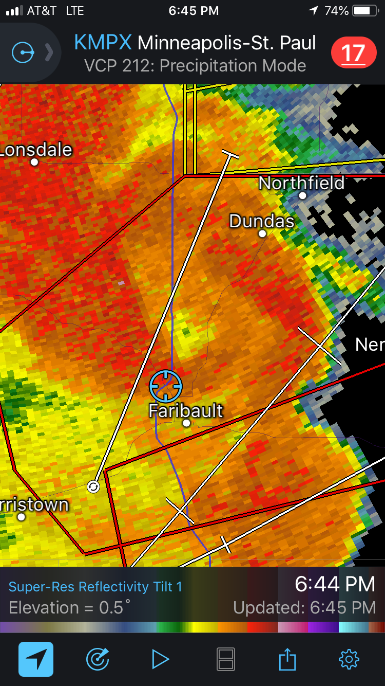
The tornado warned part of our storm was quickly approaching at nearly 70 mph, so we did our best to get a few photos and then head down Hwy 21 towards I-35. As we got past the Faribault airport, we encountered very heavy rain and a couple of very strong wind gusts that led to power poles swaying. We slowly crept down to the Hwy 21/I-35 intersection as we became inundated with 80-100 mph winds and blinding rain, so we were forced to stop at this point. Little did we know that a tornado was moving less than 1/2 mile behind us to our north and hitting the Faribault airport which we just drove past! I thought we were being hit by extreme rear-flank-downdraft (RFD) winds but it would have easily been the southern portion of a large tornadic circulation. Obviously we did not want to be in this situation, but it was very difficult to determine which parts of the QLCS line would have tornadic circulations. In fact, the tornadic circulation behind us showed up in a matter of only 2 radar scans after we already left our original spot near Roberds Lake. After waiting this out, we progressed up I-35 only to find out that it was closed due to damage. We then went up Hwy 3 north of Faribault to get home, passing by severe tree damage, some on homes, and lots of power poles and lines down. Near the Hwy 3 and Hwy 29 intersection around 4.5 miles north-northeast of Faribault, there was just under a mile wide path of trees that had bark stripped and looked clearly to be tornado damage. Here is the link to the National Weather Service damage survey for additional information: https://www.weather.gov/mpx/Sep20Tornadoes

What I think was a large and mature mesocyclone looking west-northwest from the intersection of highways 68 and 69 near the northern end of Roberds Lake near Faribault, MN.

Another view of what I believe was a mesocyclone to our northwest within the notch of the storm. Would make sense based on radar imagery. I could not tell if this was rotating. Could have been an intense downburst?

When we were re-positioning on Hwy 21 by the Faribault airport. Got slammed by intense winds ahead of an EF-2 tornado.

Closed in donut hole just north of our location as we had to stop near the intersection of Hwy 21 and I-35. Strongly indicative of a rain-wrapped tornado that passed just to our north through the Faribault airport.

Broad couplet less than 1 mile north of our location and another down by Medford. Circled in black are the likely tornadoes occurring at this point.

Couplet as the tornado was passing to our northeast, just north of Dennison, MN.
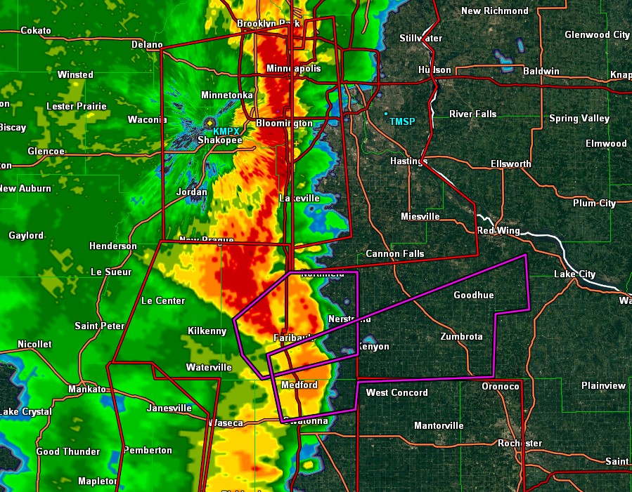
Zoomed out view of the quasi-linear convective system that spawned the 16 tornadoes across southeast Minnesota.
STORM REPORTS:

STORM PREDICTION CENTER OUTLOOKS:

JUNE 23, 2018 COLORADO: GOOD STRUCTURED STORMS ON FINAL CHASE DAY OF TRIP
This was Day 7 and last chase day of Silver Lining Tours (http://www.silverliningtours.com/) Tour 8. After chasing some decent storms in the Oklahoma Panhandle the day before, we made our way up to eastern Colorado towards the base city of Denver. There was not a lot of expectations this day due to a low-moderate instability and dewpoints only in the upper 50's to lower 60's, but deep layer shear was around 45 knots. But the models continued to break out storms east and southeast of the Palmer Divide and also off the Raton Mesa in northeast New Mexico. Since we had to be back in Denver that night, we proceeded to chase the northern target but, again, with limited expectations. To our surprise, a few storms developed along a remnant outflow boundary from the night before and this provided the lift and focus necessary for the storms to intensify and move southeast into better air. After stopping to take photos of a really cool abandoned farm house between Limon and Hugo, Colorado, we got on the first storm just south of Hugo and chased it south to east of Punkin Center. The storm actually had some pretty good structure for a while before congealing with other storms. Nice to have a better than expected chase day to wrap up the tour!

Creepy abandoned farm house between Limon and Hugo, Colorado. The dead trees surrounding the house really give it a spooky look. Thought a guy with a chainsaw was going to come flying out of this place at any moment.

The storm getting its act together south of Hugo, Colorado.

Mammatus clouds on the developing supercell.

Storm starting to take on some good structure and a solid base! Storm was high based so was not really expecting much tornado potential. 2 separate cores opening up in the distance.

Some of the best structure of the day on this severe warned supercell. Intense rain foot and hail core down the road.
Storm still exhibiting some good structure east of Punkin Center, Colorado. Almost looked like a high based wall cloud trying to form here.

Another shot of the storm east of Punkin Center towards Aroya, Colorado.

Final shot of the day of the storms well defined updraft base. Storm still had really good inflow but soon lost a lot of the good structure.

Mesoscale discussion issued at 1:36 PM MDT. Storms expected to produce large hail and damaging winds on northern end of the instability axis. Around 45 knots of bulk shear into the area, but not a lot of CAPE.

Severe thunderstorm watch issued for the area at 2:20 PM MDT.
This mesoscale discussion was issued at 5:37 PM MDT, shortly after we stopped chasing and headed to Denver. Line of severe storms with damaging winds was expected to continue southeast into the evening.
STORM REPORTS

STORM PREDICTION CENTER OUTLOOKS

JUNE 22, 2018 OKLAHOMA: SUPERCELL STORM IN THE PANHANDLE
Day 6 of chasing as a guide with Silver Lining Tours (http://www.silverliningtours.com/) took us to the Oklahoma Panhandle. There was a stalled front in place reinforced by an outflow boundary from overnight storms. There was southeast flow at the surface, leading to upslope flow into the Raton Mesa. Instability built to 2,000-3,000 j/kg into this area during the afternoon with middle 60's dewpoints and bulk shear of 55-60 knots. A surface low also developed on the Raton Mesa on the tail end of the front. We initially positioned ourselves near Andrix, Colorado. It took a while, but cumulus towers kept forming right on the low and on the Raton mesa, while a smaller cumulus field was located to the east along the front. 3 storms finally broke through the cap from Andrix to Springfield, Colorado, while another storm rolled off the Raton Mesa to our south, weakened, and then intensified west of Boise City, Oklahoma. We chose this southern storm and headed down Hwy 385 to just north of Boise City, just as the storm produced a wall cloud and became tornado warned. Another storm came up from the south and interfered with our storm, effectively choking off the wall cloud just as it was getting interesting. I really think this storm would have produced a tornado if the southern storm had not interfered. We chased the storm east towards Guymon and eventually to Balko where a tornado was reported. We could not confirm at this point near Balko that it did produce and I seriously question the report as we had a good view of the action area the whole time. Either way, it was a nice storm but turned into a raging mesoscale convective system (MCS) shortly after Balko as storms congealed and got messy.
Mammatus under the anvil of the storm to our south near Utleyville, Colorado. We eventually went south and chased this storm.

Cool shear funnel out the back of the developing storm near Utleyville, Colorado.

Thunderstorms erupting to our northwest as we watched near Utleyville, Colorado. The furthest west storm had an echo top that exploded over 50,000 feet very quickly.

Got down to the storm near Boise City, Oklahoma, and this beauty of a wall cloud was there to treat us. Raging hail core to the right (north) side.

The storm became tornado warned at this point as the wall cloud began rotating and pulling up focused scud tails into the base. Rear flank downdraft winds coming around the south side that you can notice by the dirt on to the southwest side of the wall cloud as we look due west.

Nicely structured wall cloud that continued to have rotation near Boise City, Oklahoma. This was shortly before the storm to the south came up and interfered.

View of the storm near Balko. At first glance, this may look like a shelf cloud and an outflow dominant storm, but there was still inflow into the storm here and it became tornado-warned once again due to signs of rotation on radar. Focused area of scud rising into the base on the left side of this image.
Mammatus clouds on the back of the storm near Hardesty, Oklahoma.

Mesoscale discussion issued at 2:52 PM CDT

Severe thunderstorm watch issued at 3:30 PM CDT. Big threat for severe wind due to the expectations of a severe MCS to develop and track east along the front.
Mesoscale discussion issued at 5:14 PM CDT. Bullseye of CAPE increasing to 3,000 j/kg iwth 55-60 knots of bulk shear across the area.
Mesoscale discussion issued at 7:12 PM CDT as storms were congealing and forming a severe MCS.
STORM REPORTS

STORM PREDICTION CENTER OUTLOOKS

JUNE 19, 2018 COLORADO: THE PROSPECT VALLEY TORNADO
The 3rd day chasing as a guide for Silver Lining Tours (http://www.silverliningtours.com/) was a great one! We initially thought that storms would form off the Palmer Divide southeast of Denver and intensify further east towards Last Chance. Cumulus towers went up and down several times on the Palmer Divide but never could quite get going. However, storms developed just west and northwest of Denver on the mountains in the upslope flow region of the Denver Cyclone (DCVZ). 3 separate supercells developed and moved off at relatively the same time. We chose the middle storm as it looked the most intense, and this storm soon became tornado warned very early, shortly after 1:30 PM MDT! We chased the storm from near Fort Lupton over to Keenesburg where it produced an extremely photogenic tornado in Prospect Valley, Colorado. After the tornado lifted, the storm cycled a few more times but never could put down another tornado. We ended up finally leaving this storm and heading south to the tail end storm near Deer Trail. This storm also became tornado warned and quickly a high precipitation supercell with some impressive structure. We ended up chasing this storm down to Limon before letting it go as it became outflow dominant. An awesome chase day!

Wall cloud on the storm near Fort Lupton as it soon becomes tornado warned shortly after 1:30 PM MDT! Storm had just moved off the foothills and intensified quickly.

Massive wall cloud on this storm now just east of Fort Lupton.
Terrific structure! The entire storm was rotating. Backwards C in the wall cloud indicates rear flank downdraft cutting into the back side.

A wider view of the storm.
Wall cloud becomes better organized and the first funnel cloud forms in the middle. Rain curtains wrapping around the entire wall cloud.

Wider view of the funnel, wall cloud and the storm. I love the scenery and how far you can see in eastern Colorado!
Tornado! Initially obscured by the rain but it eventually came out for us to get a great view.

Amazing tornado and structure to the storm! Near Prospect Valley, Colorado close to Keenesburg.

Another incredible view of the storm and the tornado as it changes shape.

Incredible twisting and turning elephant trunk tornado! This was from around 2-3 miles away (estimated).

After producing the tornado, the storm continued to cycle more ragged wall clouds for another few hours.

This was right when we got on the southern, tail end severe storm down by Deer Trail, Colorado. The storm was still a bit high based but had great structure.

A bit more outflowish here, but the storm still had great structure and lighting near Agate, Colorado.

Loosely organized wall cloud to our north near Agate, Colorado.
Beast of a tornado-warned, high precipitation supercell near Limon, Colorado.
Shelf cloud on the storm as it rages towards us east of Limon.

View of the shelf cloud, looking northwest.

iPhone pano of the storm and shelf cloud.
Mesoscale discussion issued at 11:48 PM MDT, mentioning the threat for a few tornadoes. Solid 50-55 knots of bulk shear across the area with 1500-2000 j/kg of MLCAPE already.

Tornado watch issued at 12:25 PM MDT.

Mesoscale discussion issued at 1:54 PM MDT.
STORM REPORTS

STORM PREDICTION CENTER OUTLOOKS

JUNE 18, 2018 COLORADO: SENSATIONAL STORM STRUCTURE
Day 2 chasing as a guide for Silver Lining Tours: http://www.silverliningtours.com/ We stayed in northeast Colorado as supercell thunderstorms developed on the mountains and then rolled off just north of Denver. We ended up staying close to I-76 and chasing these storms from Fort Lupton to Fort Morgan. The storms exhibited terrific structure throughout their life cycles!

Supercell rolling off the mountains northwest of Denver near Erie, Colorado. This is looking up at the updraft. We drove through quarter size hail upon having to punch through the core from the north.

Non-rotating wall cloud on the storm near Erie, Colorado.

Terrific structure of the storm with wall cloud underneath in Hudson, Colorado.

Terrific looking storm near Keenesburg, Colorado.
Incredible storm structure!

Looking at the south side of the storm with a well defined inflow tail.

Wall cloud on the storm as we approach Wiggins, Colorado.

The wall cloud takes on an even better shape a short time later.

Mesoscale discussion issued at 3:06 PM MDT highlighting the area expected to have severe thunderstorms into the afternoon and evening. Modest instability at this point but decent bulk shear of 45 knots. Instability did increase through the afternoon.

Small severe thunderstorm watch issued at 6:35 PM MDT. Storms were not moving very fast and were not expected to hold together very well further east. Ended up having some flooding rain along I-76 as a result of training thunderstorms into the evening.
STORM REPORTS

STORM PREDICTION CENTER OUTLOOKS

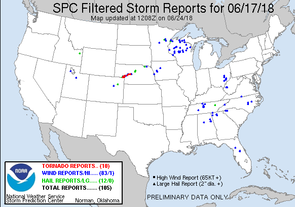
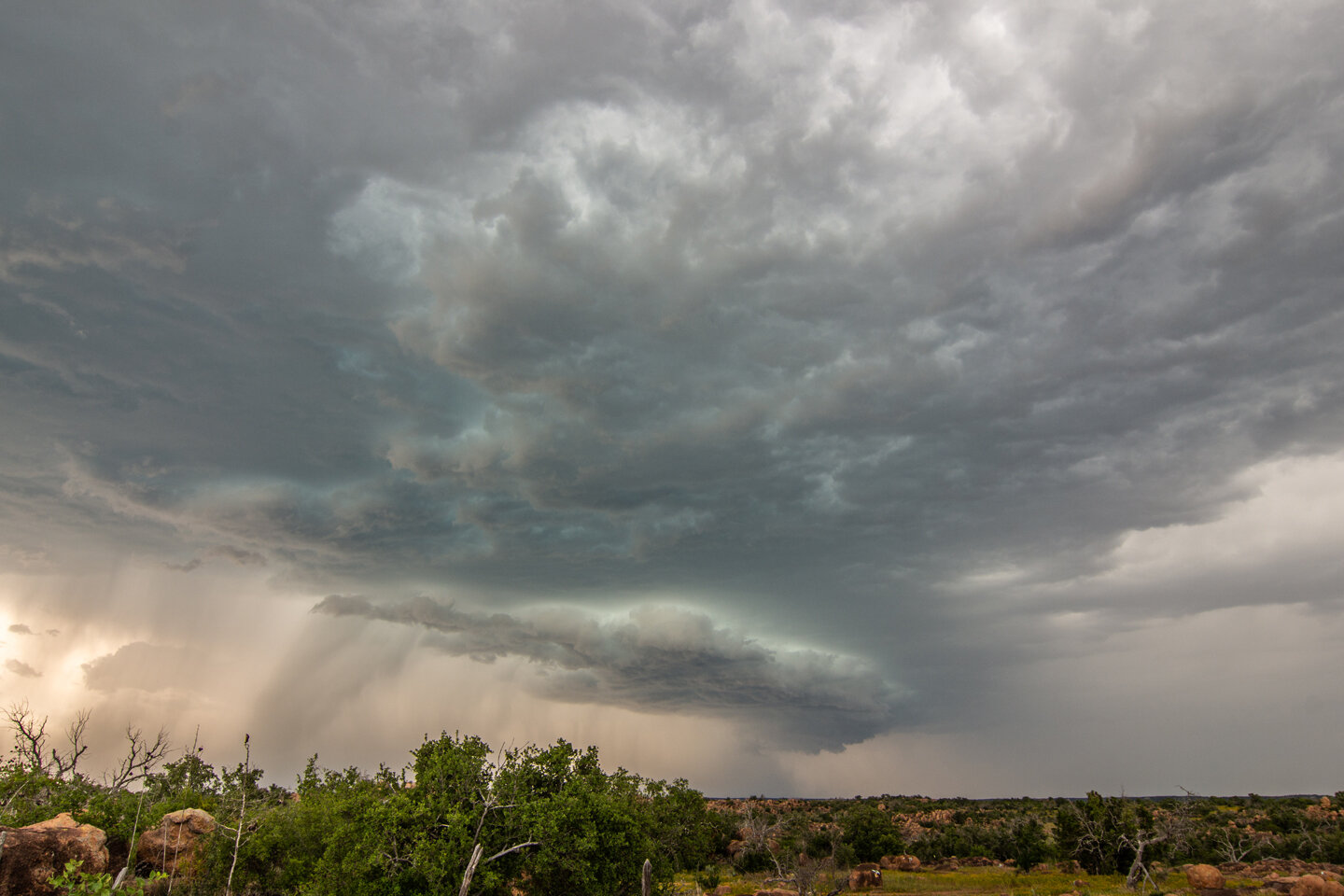
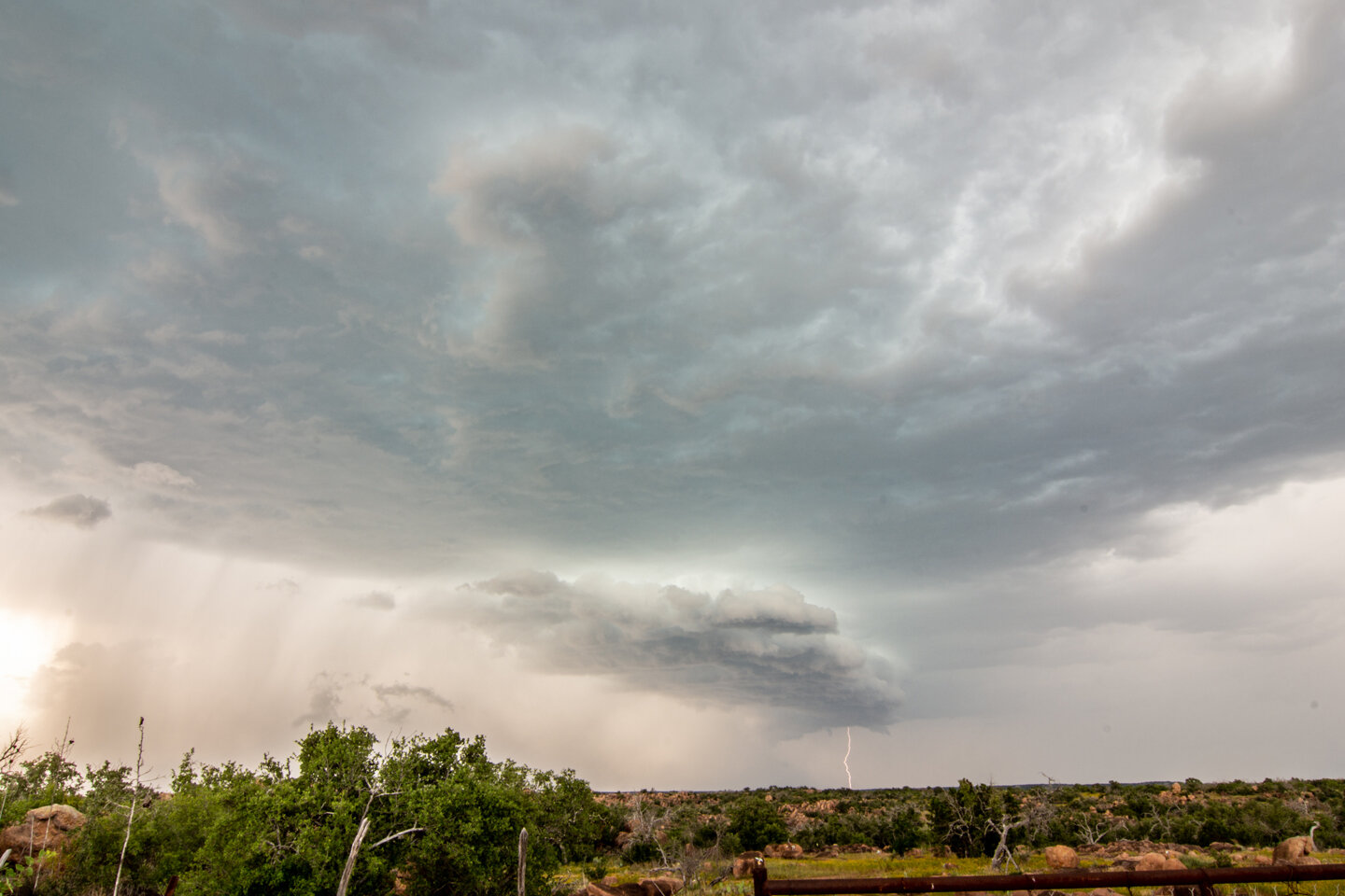
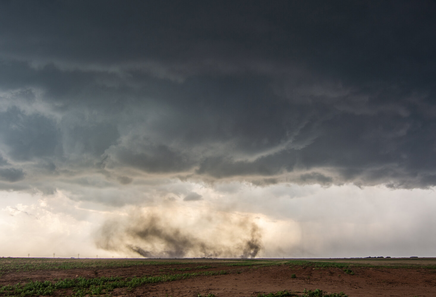
JUNE 17, 2018 NEBRASKA: TWO TORNADOES AND A WICKED SHELF CLOUD
Day 1 of storm chasing as a guide with Silver Lining Tours (http://www.silverliningtours.com/)! We chased a couple of supercells from near Julesburg, Colorado to north of Ogallalla, Nebraska. Along the way, we saw two tornadoes. The first was a dirt obscured tornado near Julesburg and the second was near Big Springs, Nebraska and was from a longer distance away. We did briefly see a third tornado near Ogallalla but did not get a decent shot of it since we were re-positioning ahead of the storm.

Wall cloud forming on the storm near Julesburg, Colorado.

Large wall cloud on the storm near Julesburg, Colorado. Not rotating at this point but certainly starting to look interesting!

Wall cloud starting to tighten up as rear flank downdraft comes around the south side of the storm. Strong inflow winds at this point.

Rotating wall cloud really tightening up now with strong rear flank downdraft kicking up dirt.

There's a tornado in there! That dark area underneath the wall cloud was a confirmed tornado. Obscured from all of the dirt being blown around here.

A large, rain-wrapped funnel cloud between Julesburg, Colorado and Big Springs, Nebraska. Did not know that I captured this until going through the photos later.

Confirmed tornado in the distance near Big Springs, Nebraska. Wish we would have been closer to this thing, but we were caught getting out ahead of the storm to avoid being cut off.
Storm starting to gust out and form a shelf cloud north of Ogallala, Nebraska.

Terrific structure on this storm as it is transitioning from being a tornado produce, to outflow dominant wind and hail machine. Still tornado warned at this point with visible mesocyclone on the right side of this image.

Tour guests enjoying the storm.

Awesome shelf cloud on the storm, looking south from the previous image.

Mesoscale discussion issued at 1:05 PM MDT shortly before storms initiated. Area of low pressure slowly moving northeast along a stalled boundary. Effective bulk shear of 55 knots into the area.

Tornado watch issued at 1:35 PM MDT as storms have already initiated.

Mesoscale discussion issued at 3:53 PM MDT as severe thunderstorms are set to intensify and continue. Lower 70's dewpoints now starting to advect into the area with east to southeast winds.

Another mesoscale discussion issued at 5:47 PM MDT.

Final mesoscale discussion for the area, issued at 8:27 PM MDT as severe weather threat is starting to decrease.