July 1st Minnesota Supercells and Shelf Clouds
Intense HP (high precipitation) supercell with shelf cloud north of Franklin, MN.
HP supercell catching us even though we are driving 60-70 mph to the east. Storm gusting out a lot at this point.
What I believe to be a gustnado at the leading edge of the outflow south of Hector, MN. Notice the strong debris cloud with tighter "finger" funnel overhead. Not sure if this is indeed a gustnado, but it sure appeared like one from what I know. The debris cloud kicked up extremely fast and that is how I first noticed.
View shortly after the picture above of what I think was a gustnado at the leading edge of the shelf cloud.
Tons of dirt being kicked up due to the intense outflow winds from this storm.
Shelf cloud approaching us as we waited east of Winthrop, MN.
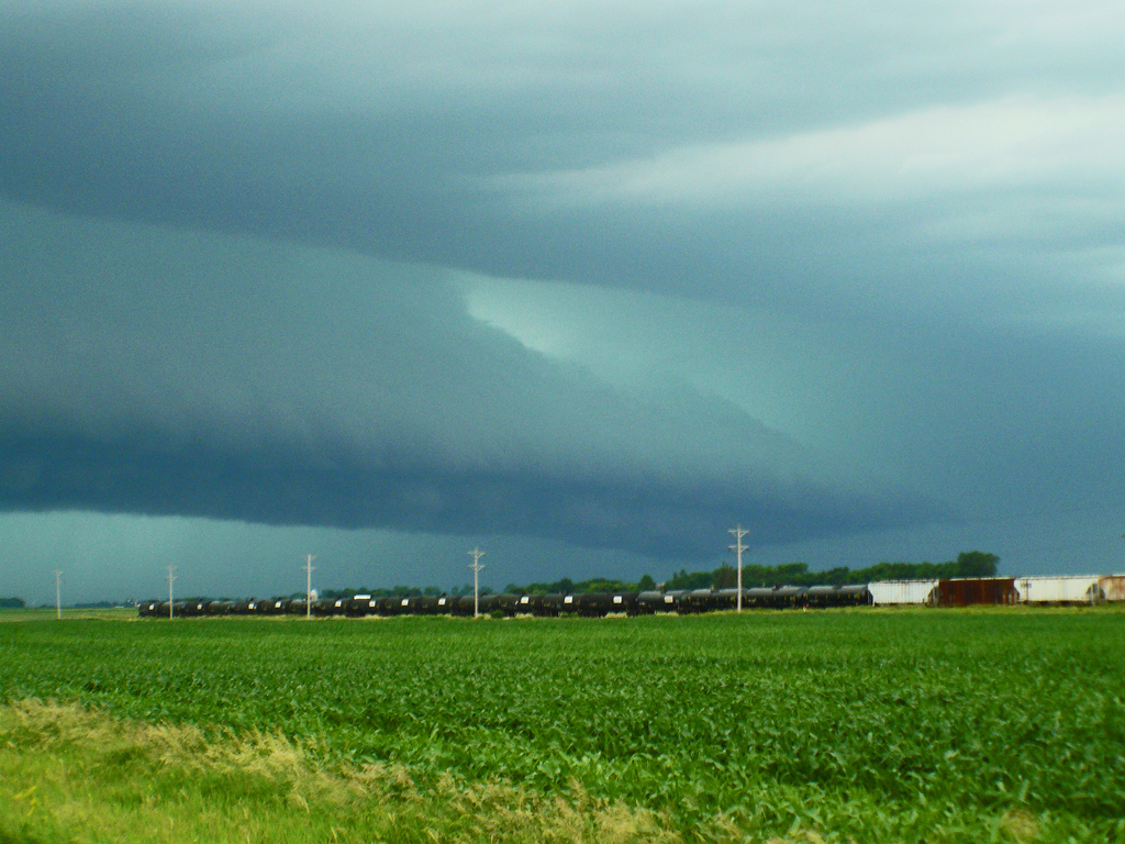
Really neat photo of a train passing ahead of the shelf cloud that was rapidly approaching our location.
Incredible shelf cloud!
Another view of the awesome shelf.
More photos from this day can be found here: http://www.flickr.com/photos/39991047@N02/sets/72157626977879903/
Our relative position compared to the intense supercell northeast of Redwood Falls.
Our relative position where we viewed the shelf cloud east of Winthrop, MN.
Storm Reports:
07-01-11 CHASE LOG: MN Computer models had slowed down the progression of a system that was expected to originally blast through MN the night of 6/30, but the days leading up to 7/1 led to increasing confidence that a severe weather event was going to take place. Temperatures across MN both on 6/30 and 7/1 had risen into the 90’s with portions of MN into the mid and upper 90’s (MSP hitting 99 on 7/1) ahead of a strong cold front that was expected to ignite severe weather across the state. Dewpoints soared well into the low and mid 70’s as well. Directional wind shear was less than adequate with primarily unidirectional winds forecast through the lower levels, although very strong deep layer shear was in place for supercells. The main player in the development of intense severe storms was extremely high instability as MLCAPE values exceeded 4000 j/kg and a corridor of 5000+ j/kg nosed ahead of the cold front in MN that was being driven eastward by a very compact and strong 500 mb vorticity max. Even though strong capping was in place, the intense forcing ahead of this vorticity center was enough to overcome the cap and sustain intense thunderstorms through eastern SD into MN and northern WI where widespread damaging wind and hail took place.
After getting off work, MaryLynn and I headed west on Hwy 19 to Hwy 169 south. A very large, beastly supercell had developed in southeast SD and was heading northeast towards our location and the plan was to intercept this cell in the vicinity of Tracy, MN. As we headed west on Hwy 14 towards Tracy, I realized the storm was heading northeast much too fast and we needed to get north and ahead of this storm ASAP. We ended up heading north of Springfield, MN on Cty Rd 4 and crossed the MN River near Franklin to get ahead of the beast that was rapidly approaching Redwood Falls. We traveled north on Hwy 5 and then east on Cty Rd 4 where I videoed the storm as it encroached on us from the west. We could barely keep up with the storm, even traveling 60-70 mph! To the southwest of Hector, I believe we witnessed a gustnado as a large and relatively tight debris cloud formed as well as a condensation funnel overhead. Pictures of this are below, but not completely sure it was a gustnado or intense outflow winds and some sort of “finger” ahead of the developing shelf. Thereafter, the storm produced intense winds as it overcame us and we saw many large tree branches down further east towards the Stewart area.
Instead of calling off the chase at this point, there were more storms developing to the southwest that would be at our location in an hour, so we stopped in Winthrop at the Eagle’s Landing Bar & Grill and had dinner. Timing was perfect as we got done with dinner and went east of town where I set up the tripod and video camera and waited for the storm to approach. This one had a beautiful shelf cloud and I managed to get about 15 minutes of really good video from this storm, as seen below. After the wall cloud moved over and we got cored, the chase was over as we could not get back out ahead of the shelf at that point as it rolled towards the Twin Cities metro.


