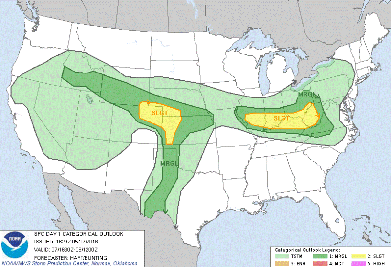
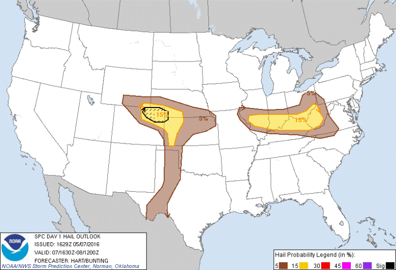
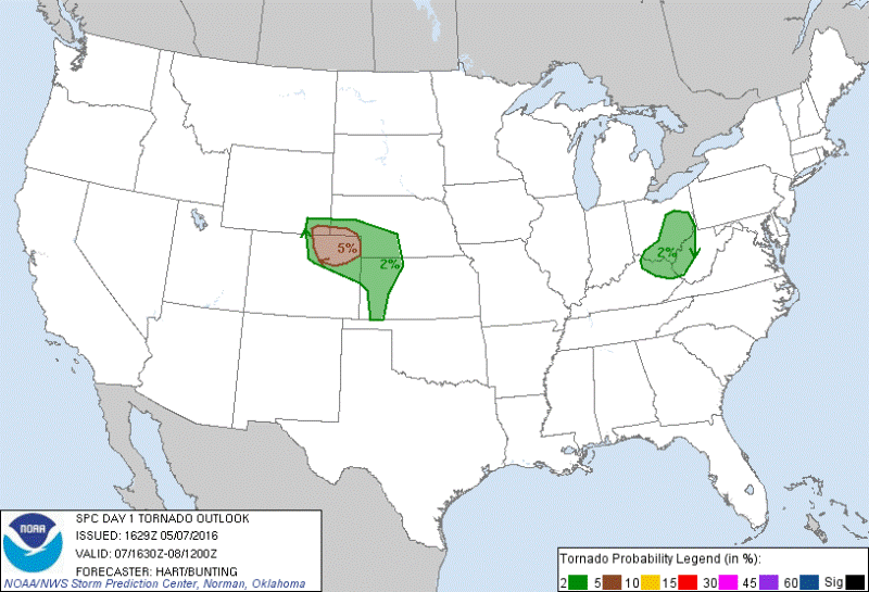
JUNE 9, 2018 IOWA: LEAVING VACATION FOR TWO TORNADOES!

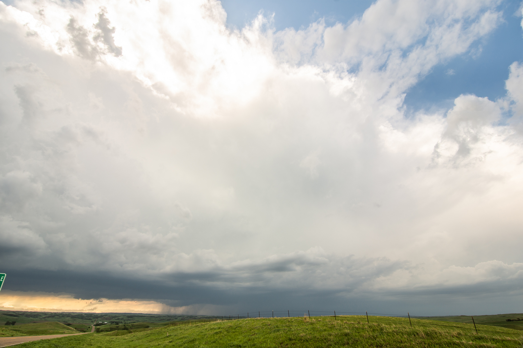
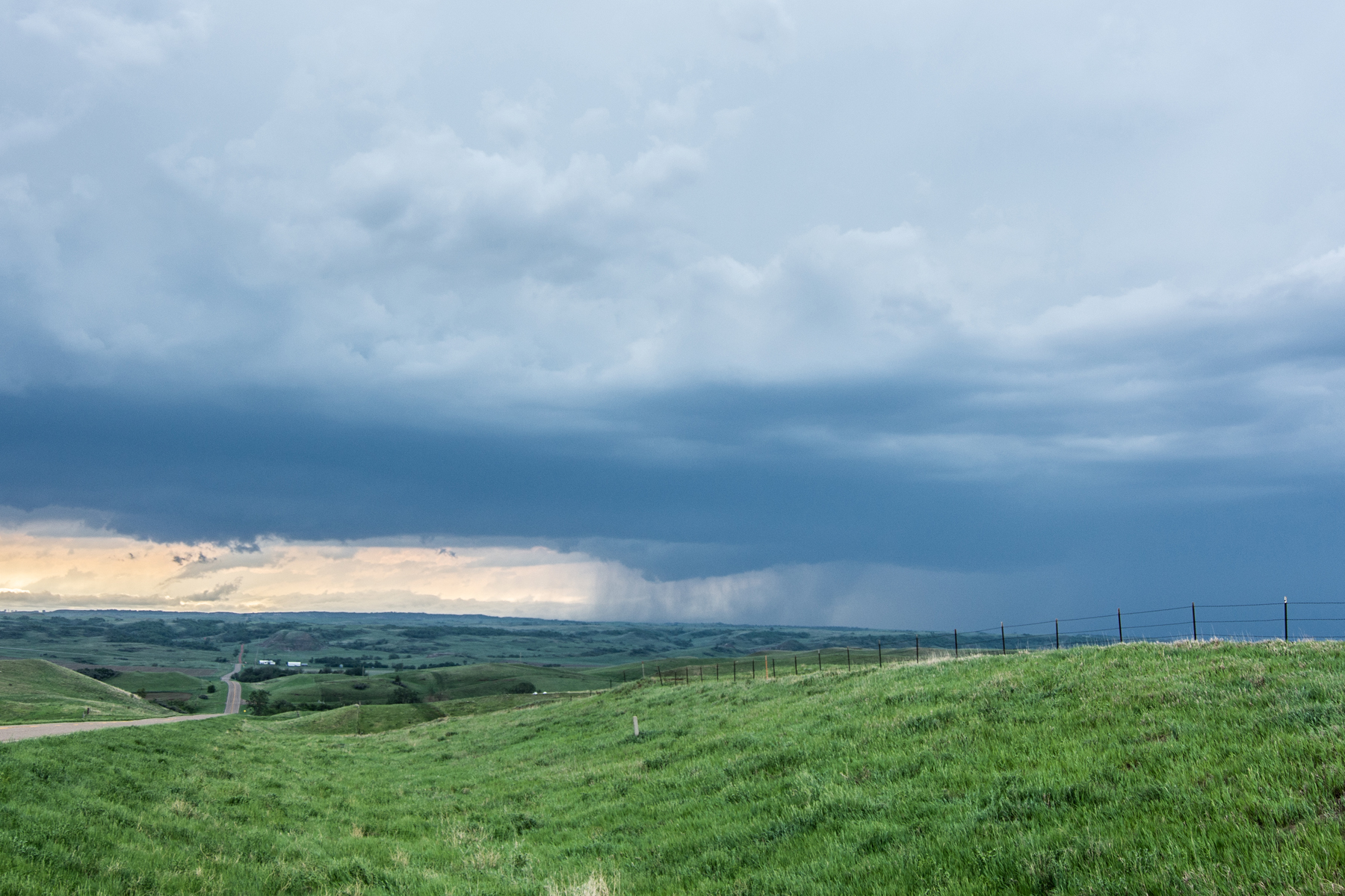
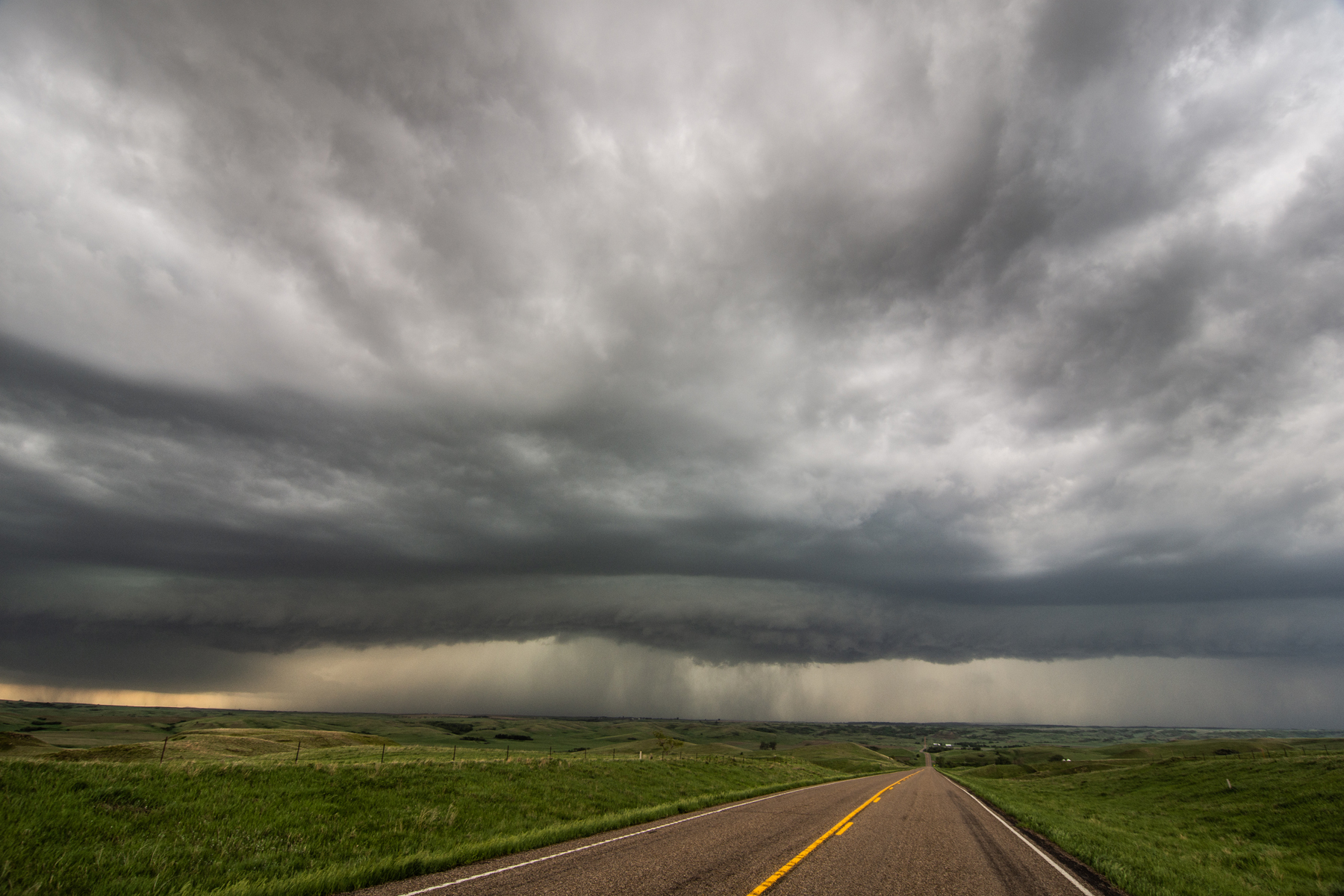
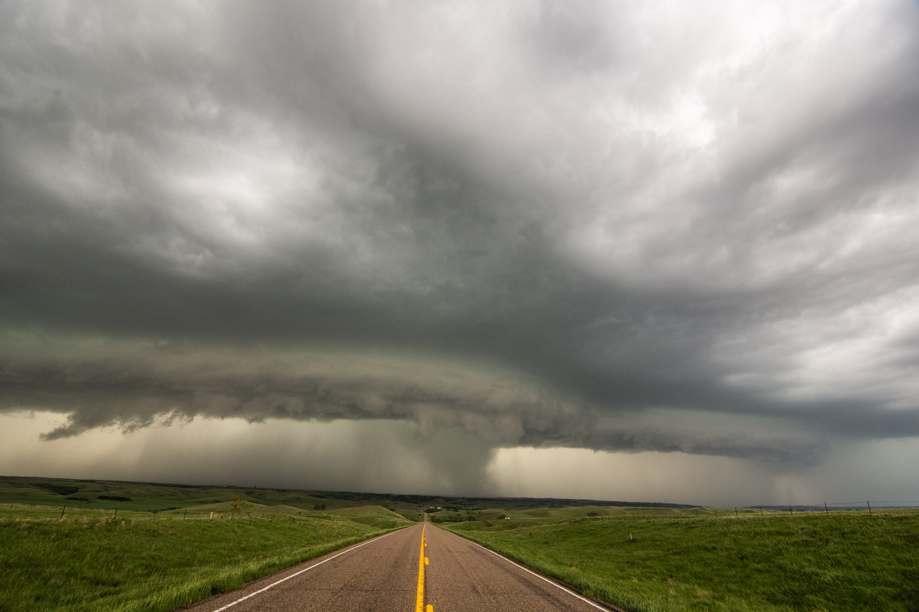
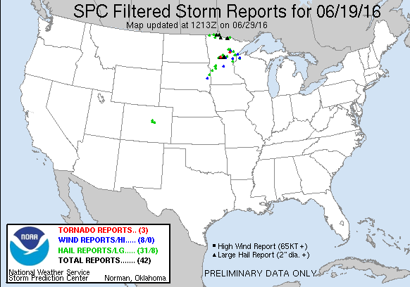
  Well, this was certainly unexpected.  After chasing a few days before, it was time for family vacation.  I had a great time on Friday and woke up on Saturday, June 9 to enjoy the day at a cabin, do some fishing, and spend time with family.  However, after looking over the observations and models Saturday morning, it soon became apparent that I had to get out northern Iowa to chase a mesoscale low pressure and warm front setup!  I met Wes and Debby Hyduke in Rochester and we went on our way to a target near Mason City.  The HRRR model completely nailed a tornadic storm that occurred in northern Iowa, just northwest of Clear Lake and Mason City.  It was one of the easiest targets that I can remember.  Basically had to find the triple point and park right in front of it.  A storm went up near Forest City, Iowa and produced a tornado just east of town, while another tornado occurred on this storm south of Fertile.  Just south of Fertile, there was a rapidly spinning mesocyclone on a separate wall cloud than the one that produced the tornado soon after.  The storm continued to be tornado warned southeast of Mason City but became a high precipitation supercell and eventually more outflow dominant.  It was a great spur-of-the-moment chase!

DSC_0509-2.jpg

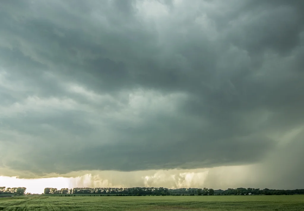
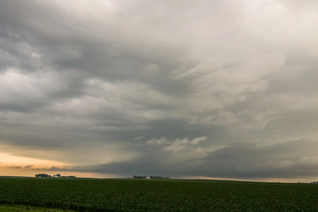
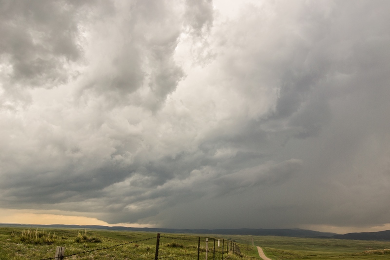
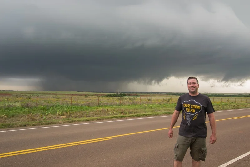
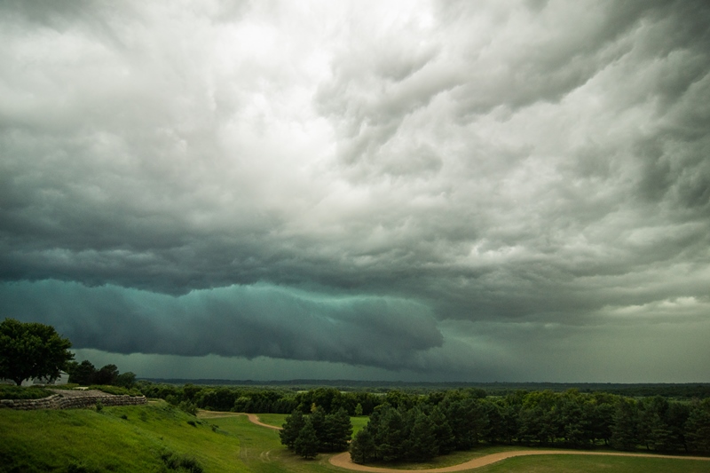
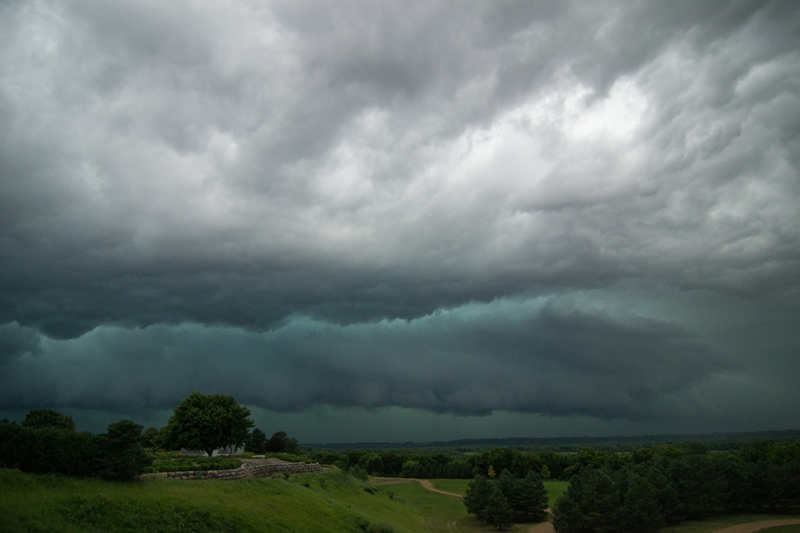
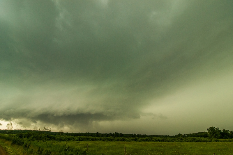
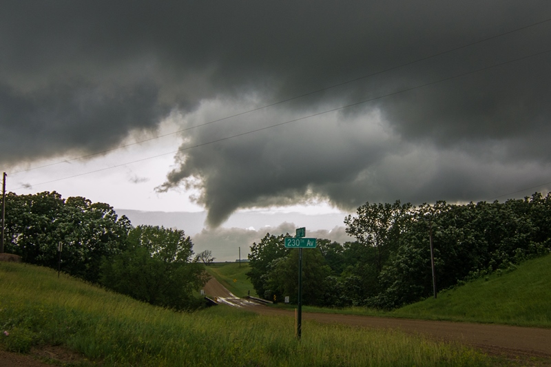
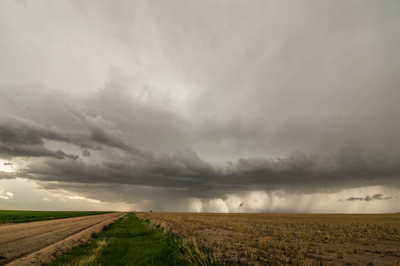
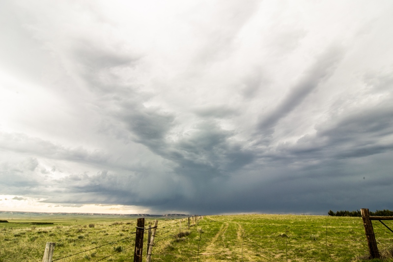
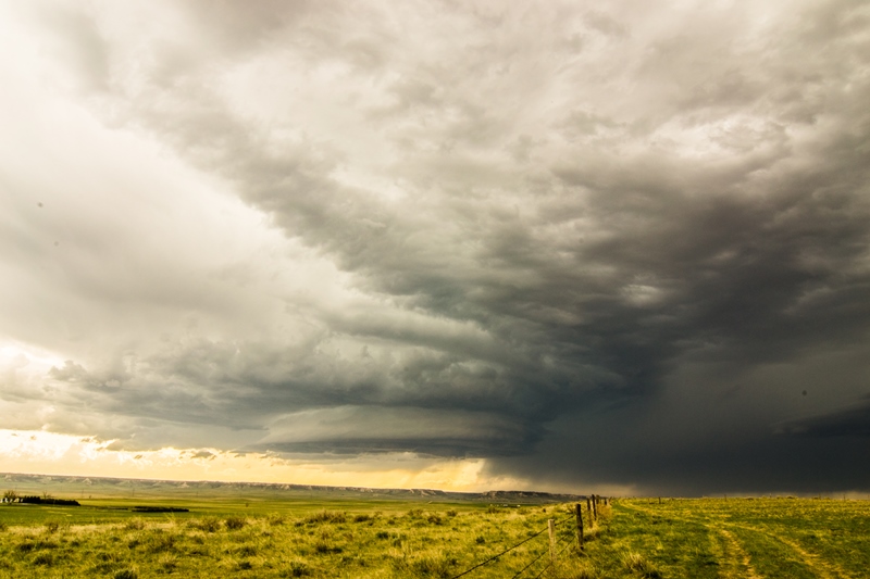
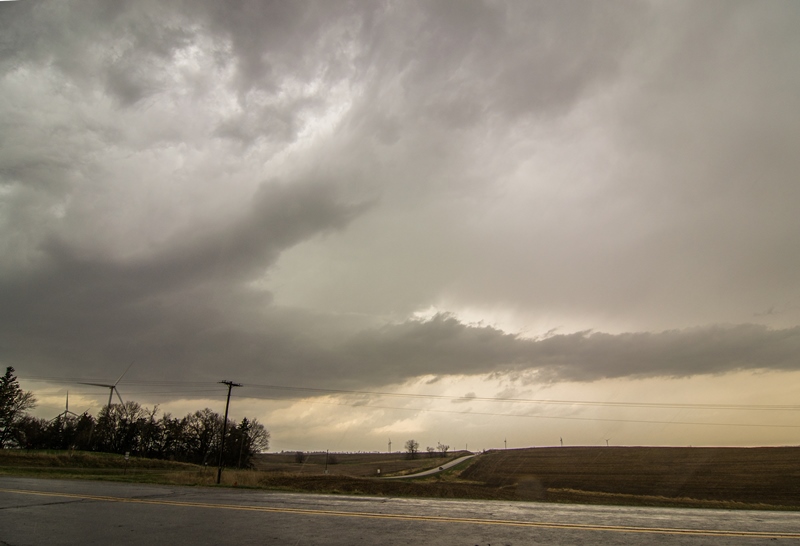
  Wall cloud on the storm near Forest City, Iowa.

IMG_0279.JPG
DSC_0531.jpg

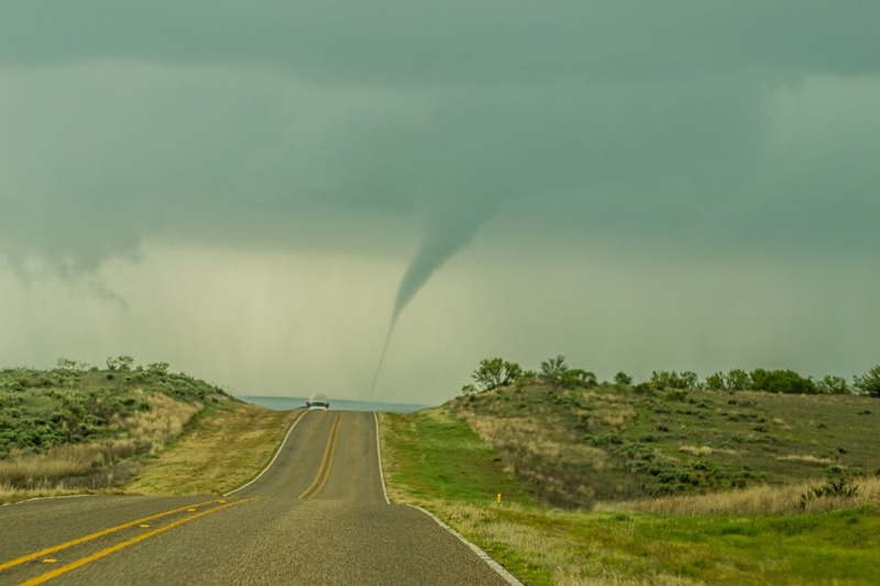
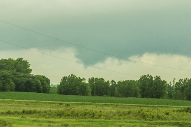
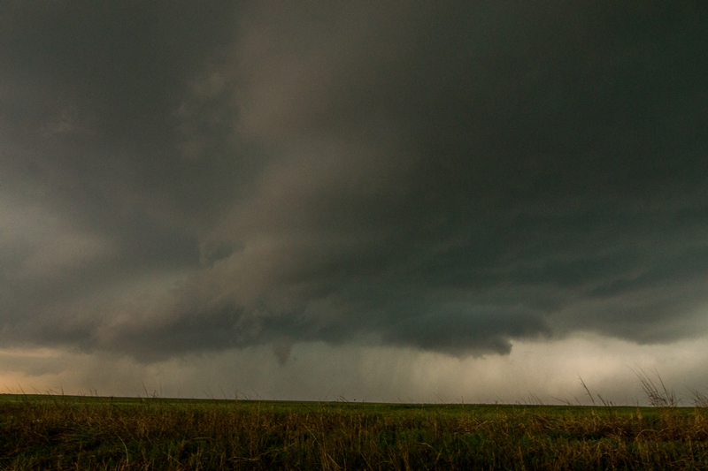
  Tornado occurring off the right side of the wall cloud with visible debris cloud at the ground.  

DSC_0531-2.jpg

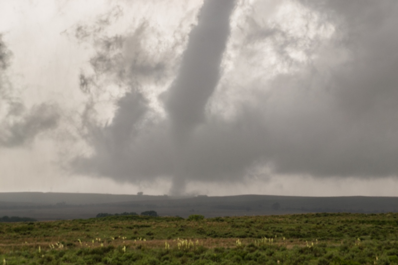
  Closer view of the wall cloud and tornado.

DSC_0554.jpg

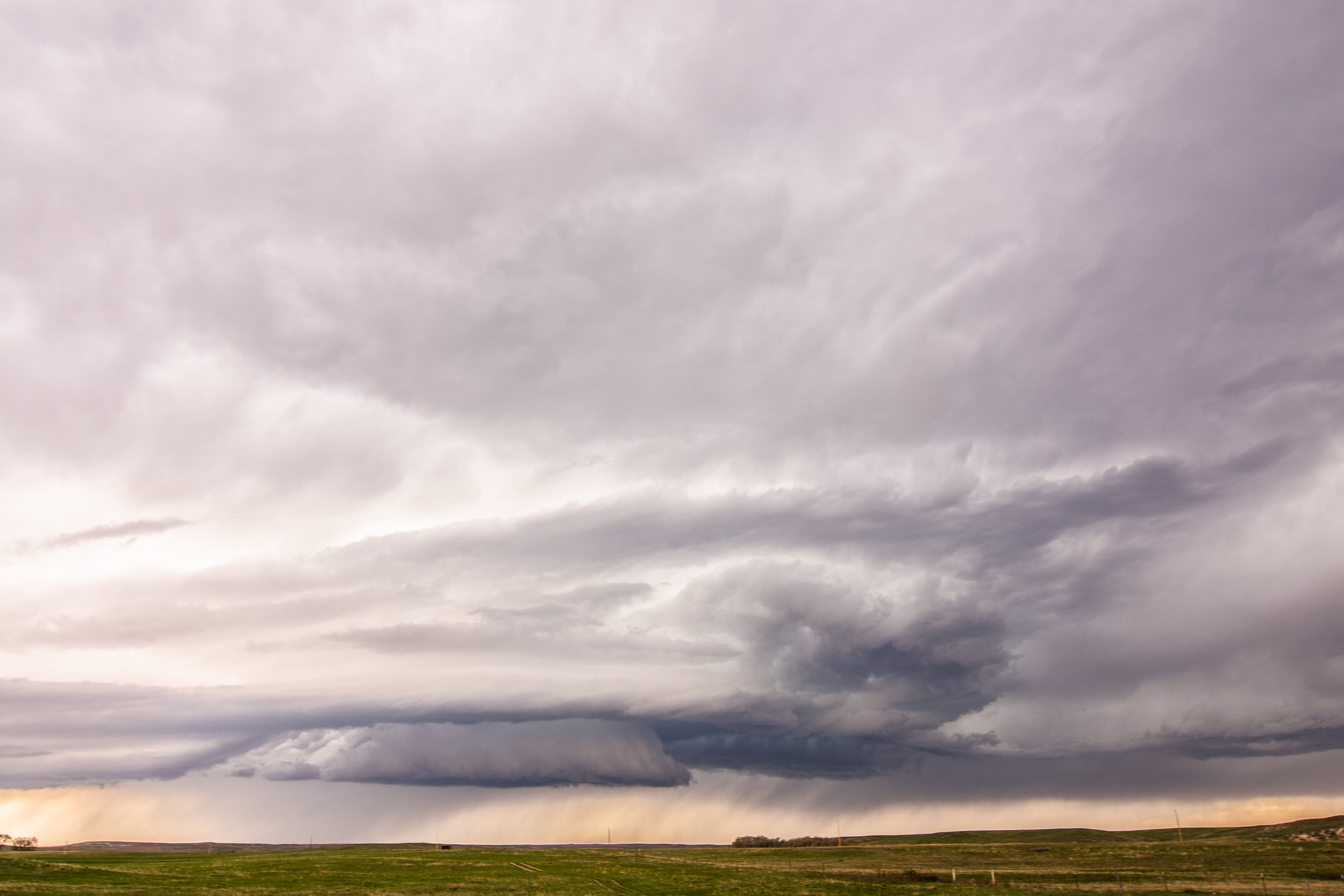
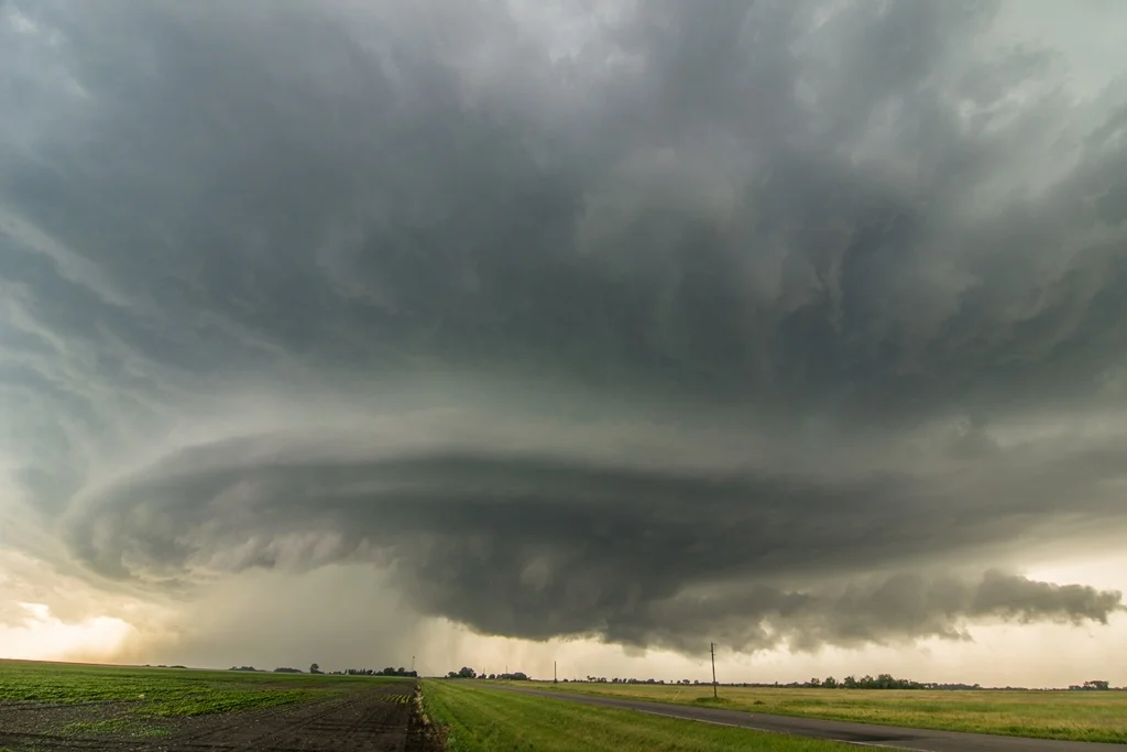
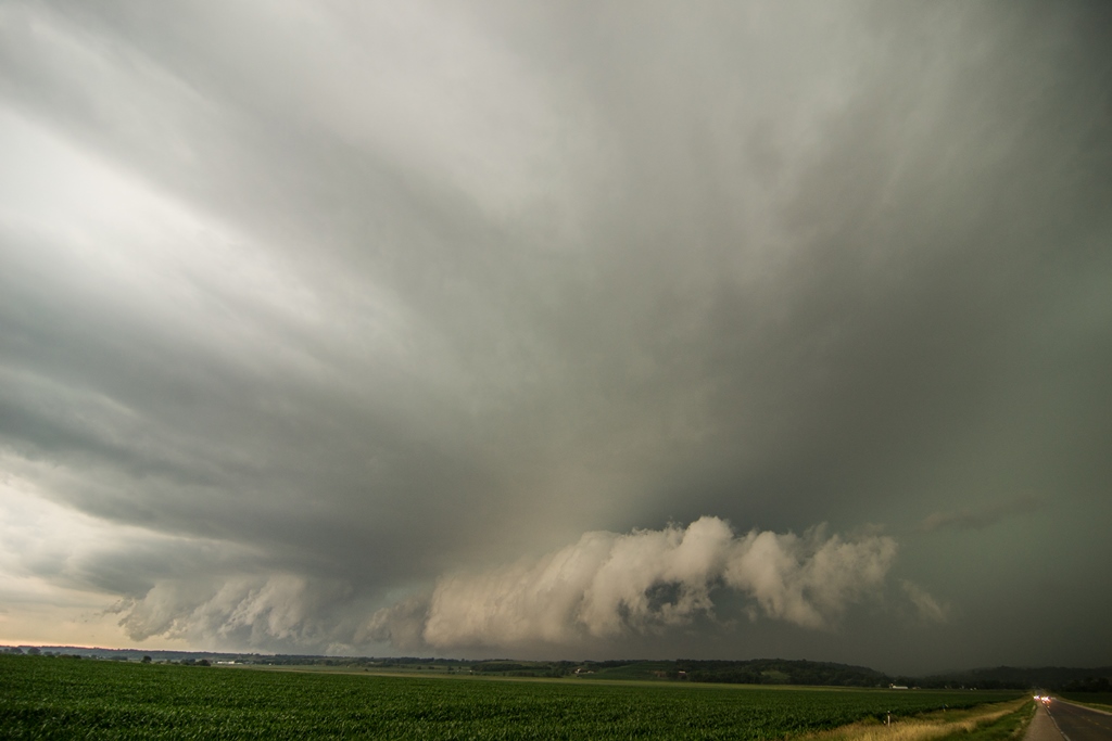
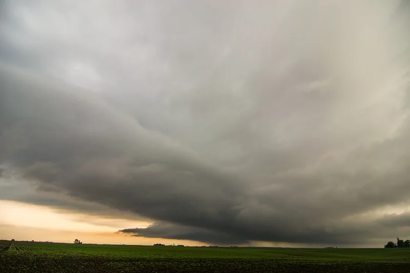
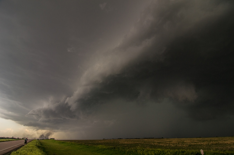
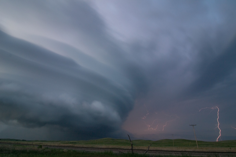
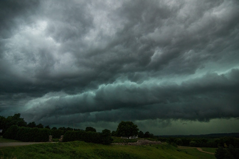
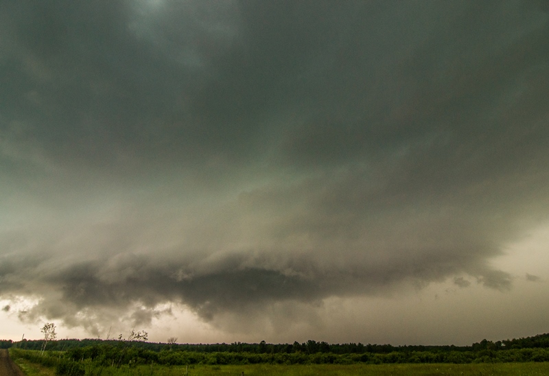
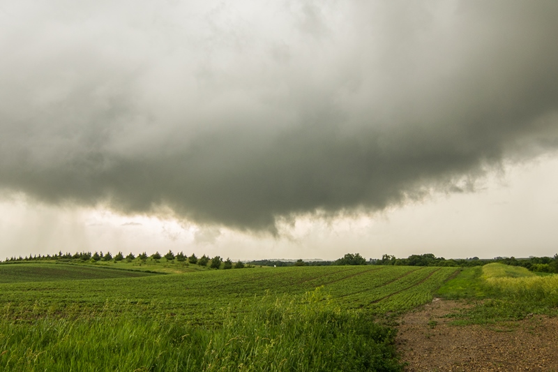
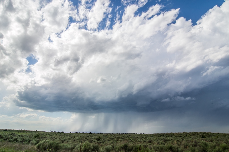
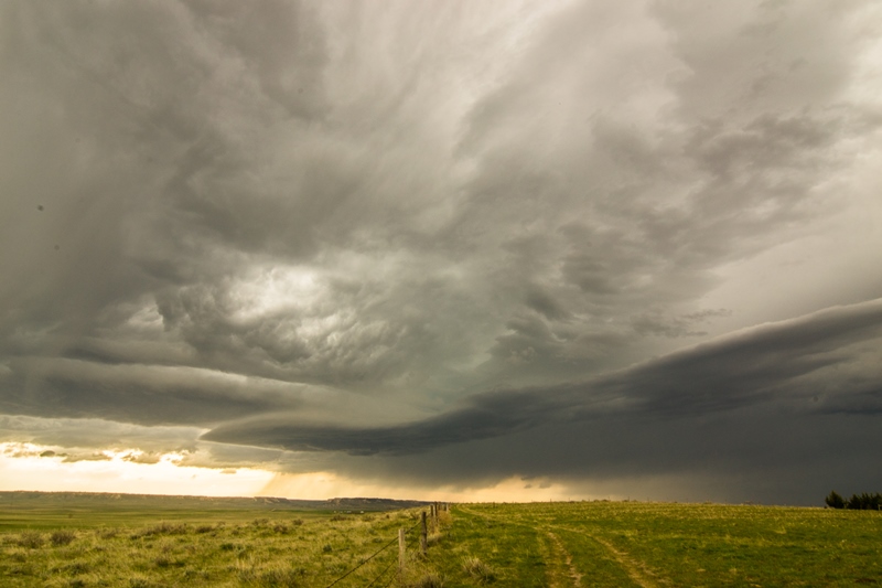
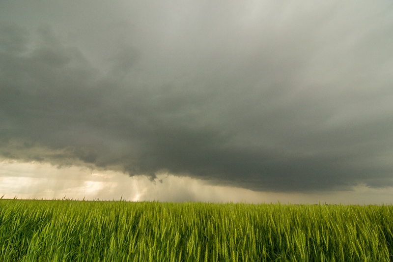
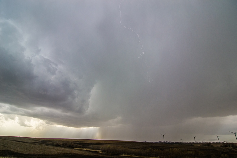
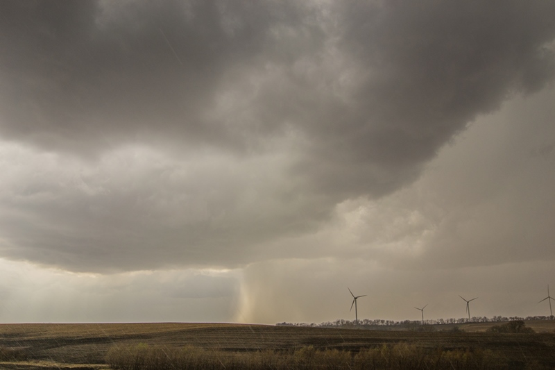
  Wall cloud forming on the storm just south of Fertile, Iowa.

DSC_0578.jpg

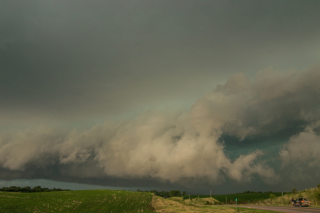
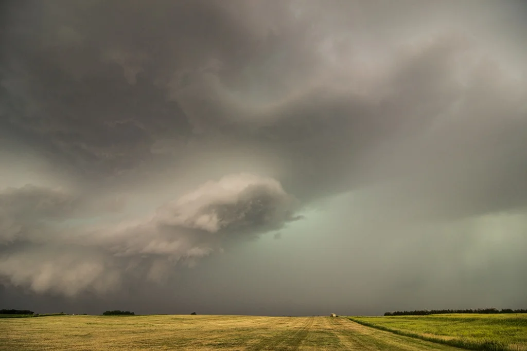
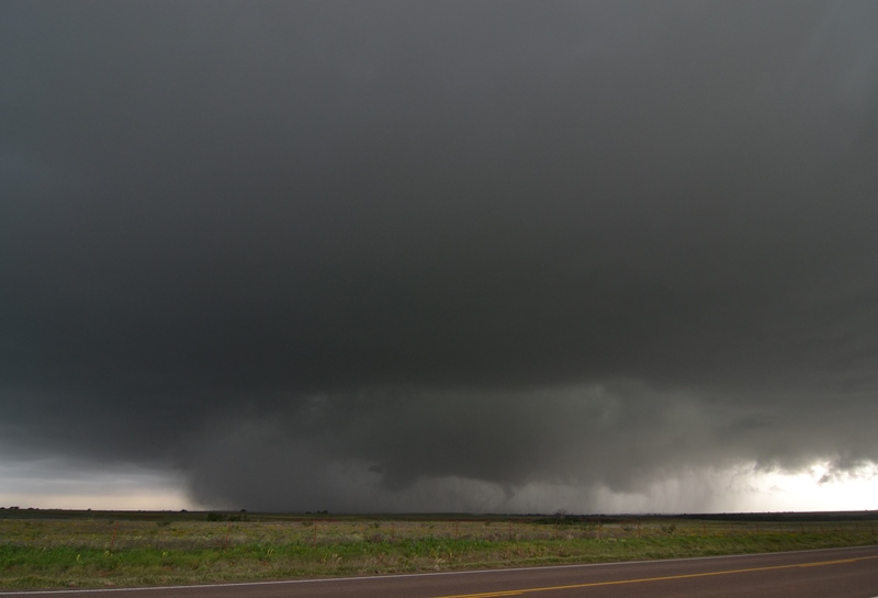
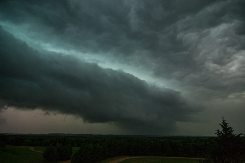
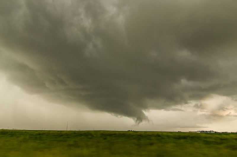
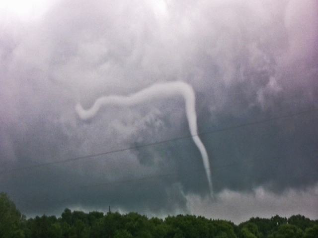
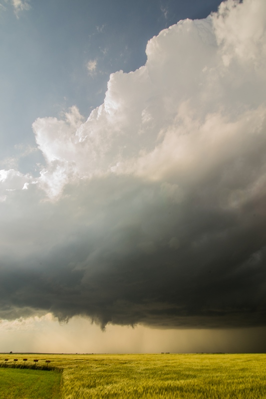
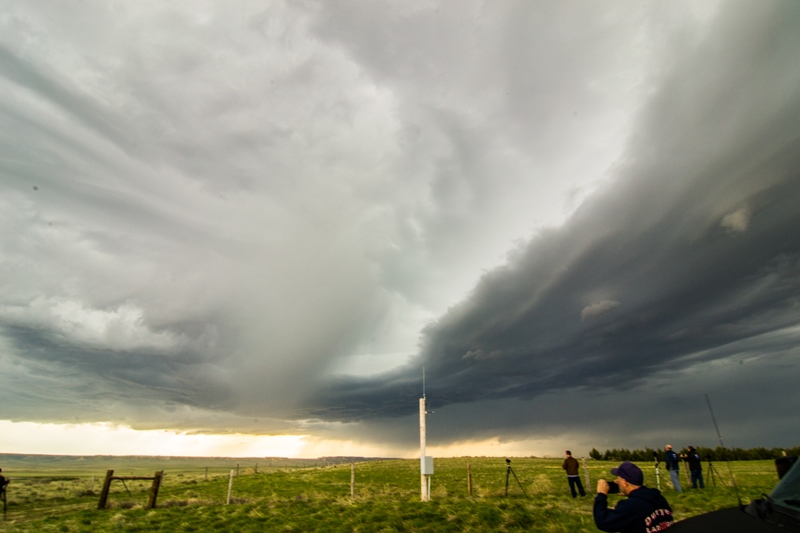
  Rapidly rotating wall cloud tightening up and attempting to produce a tornado.  Large condensed inflow tail screaming right to left and around this wall cloud at this point.

DSC_0587.jpg

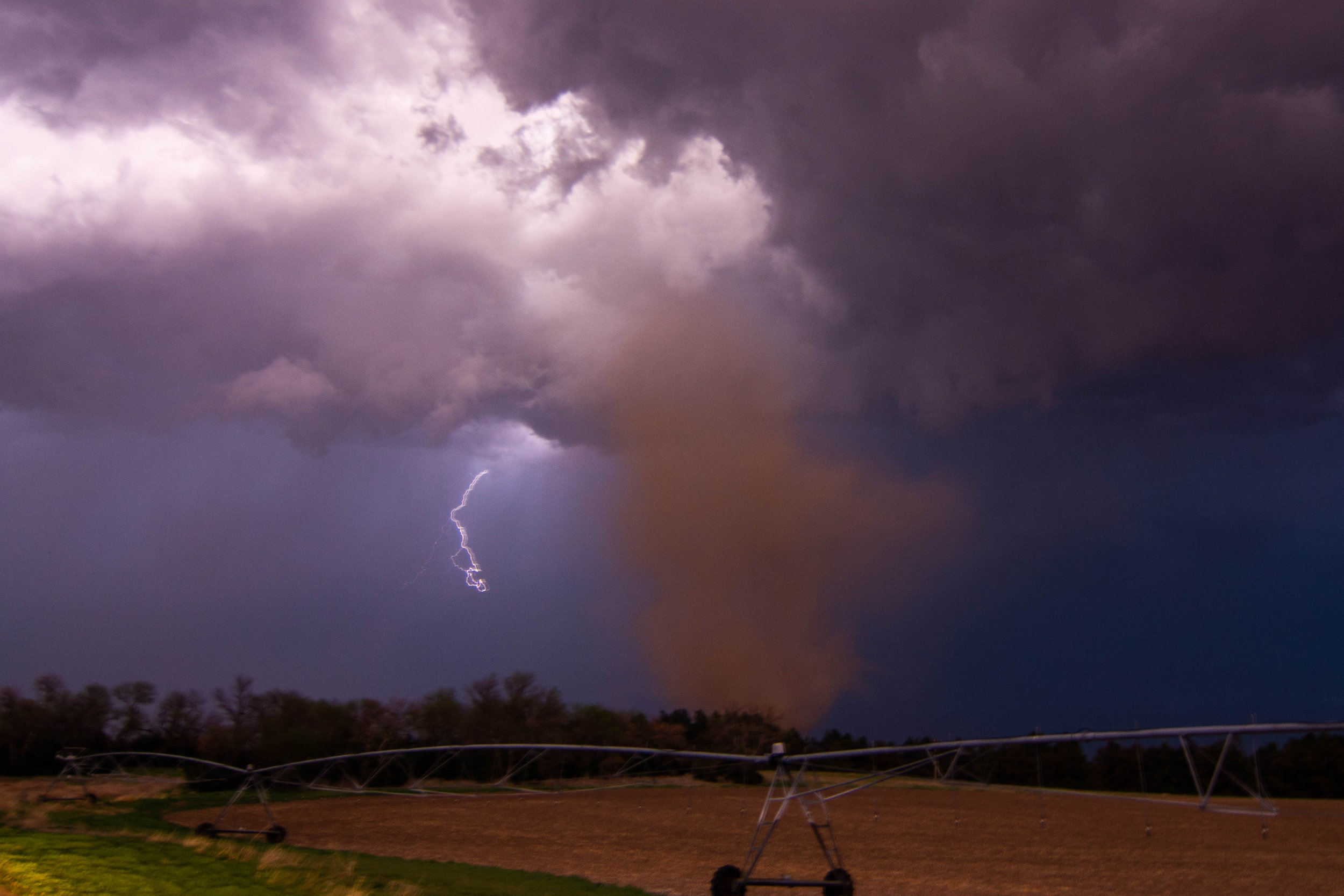
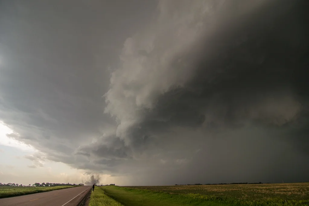
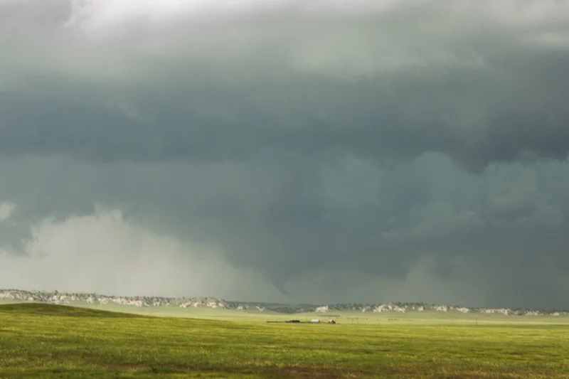
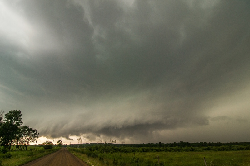
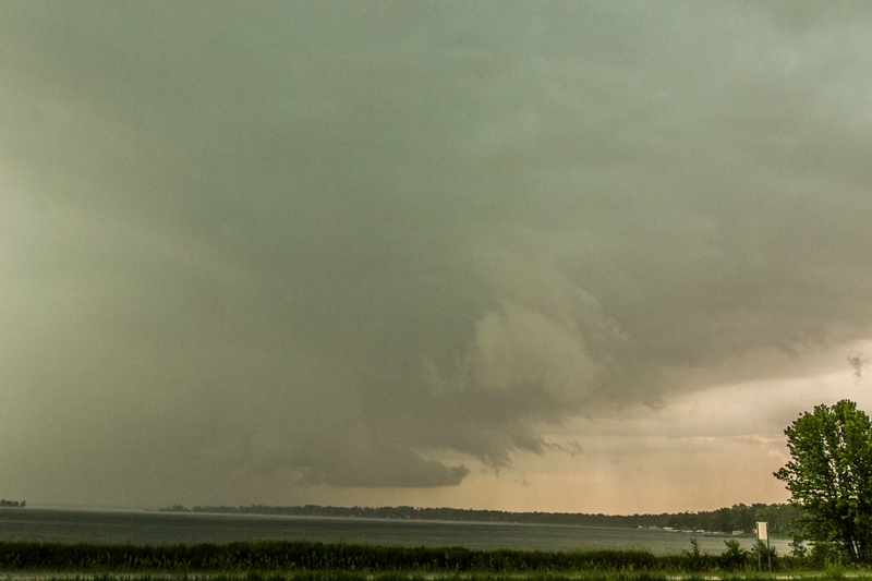
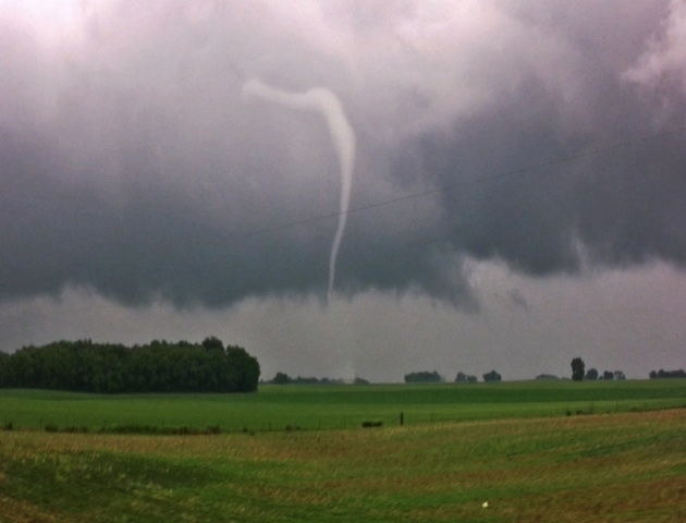
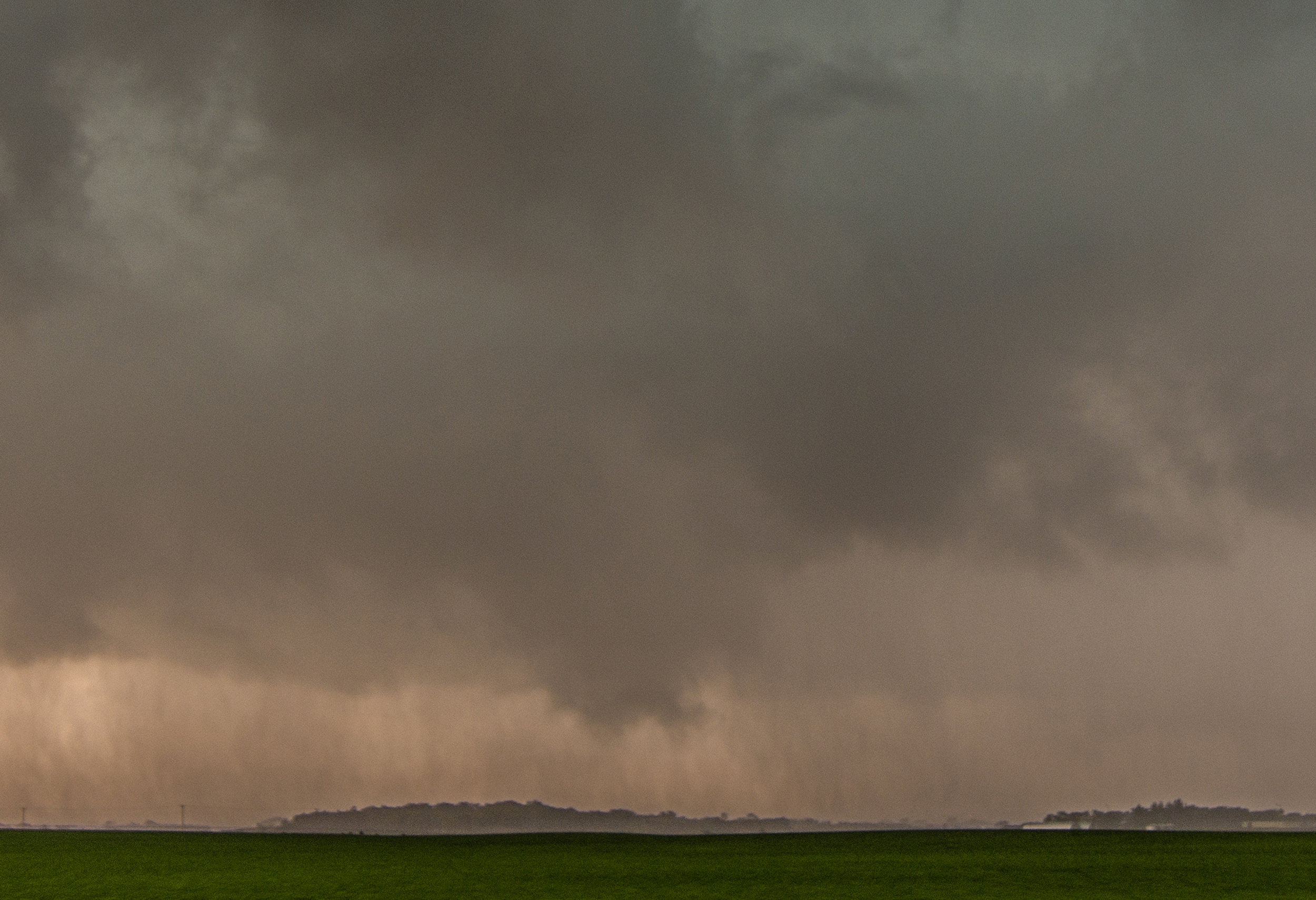
  Around the time of the tornado reported southeast of Fertile, Iowa and northwest of Clear Lake.  Could not confirm that it was touching down at this point due to trees, but it was reported so I'm counting it as tornado #2.

DSC_0597-2.jpg

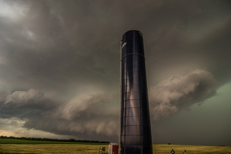
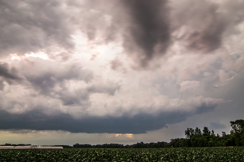
  Area of rotation, possible funnel cloud, near Mason City, Iowa.  Storm still tornado warned.

DSC_0610.jpg

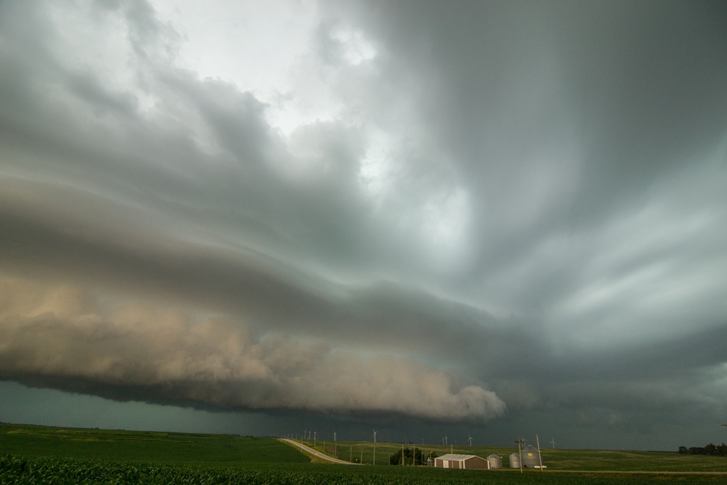
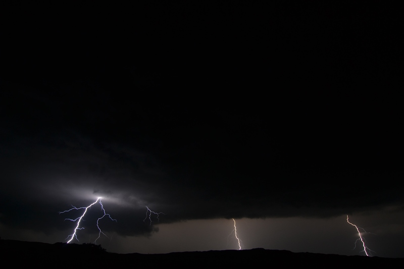
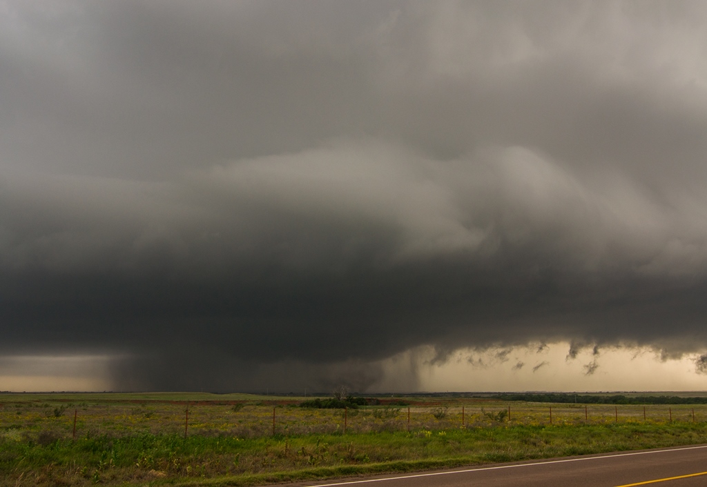
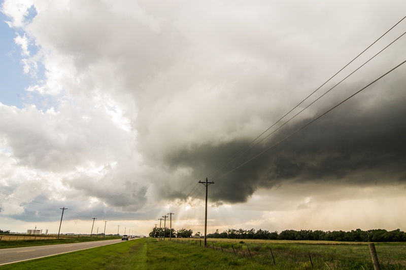
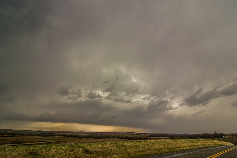
  Severe thunderstorm approaching Charles City, Iowa.  Storm still has a visible wall cloud on the right side, but soon lost this as it became more outflow dominant.

DSC_0616.jpg

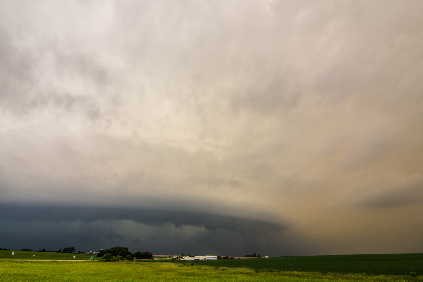
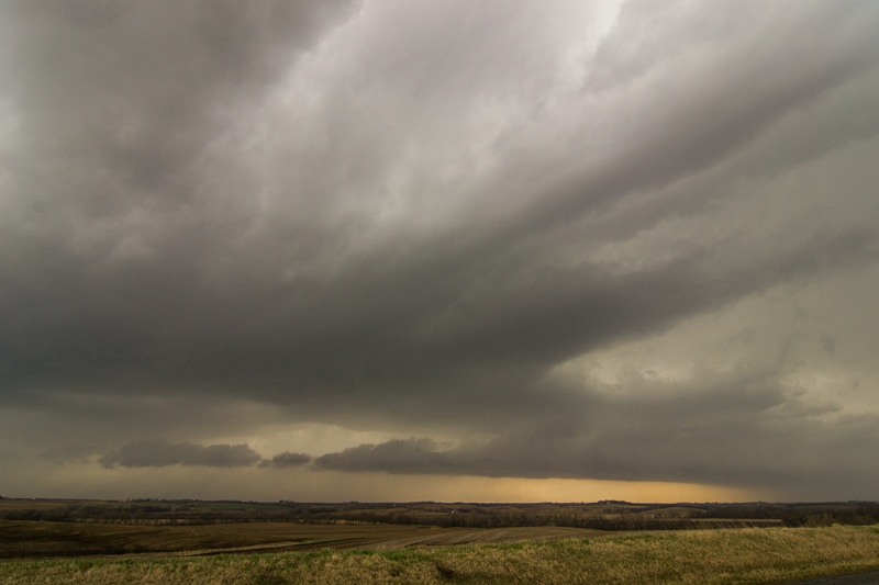
  Another shot of the storm approaching Charles City, Iowa at the end of our chase.

mcd0682.gif

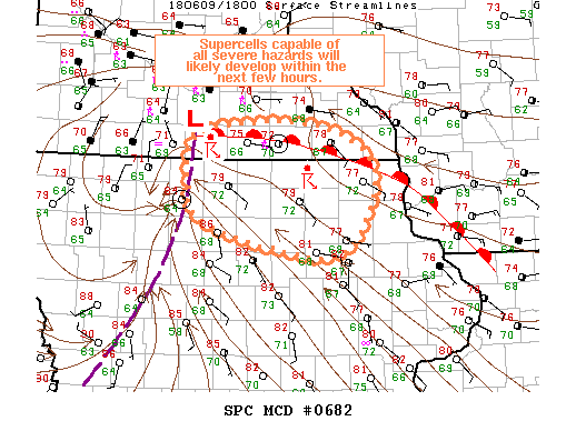
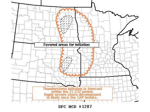
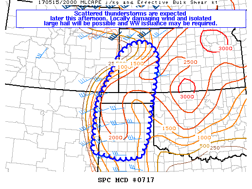
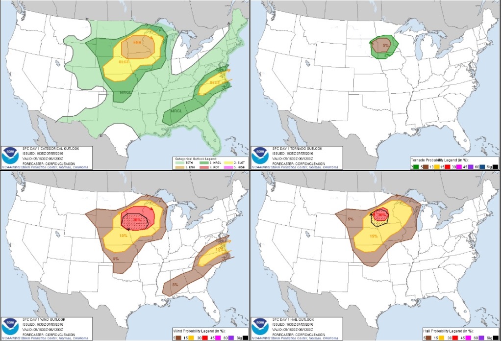
  Mesoscale discussion issued at 1:46 PM CDT.  Area of low pressure moving southeast along the warm front.  Isolated supercells expected to develop just ahead of the low.

Tor Watch.JPG

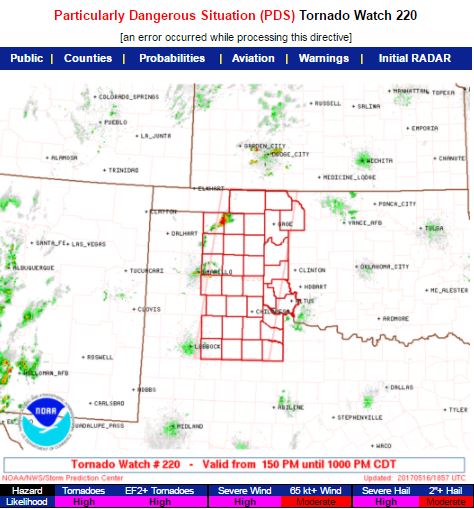
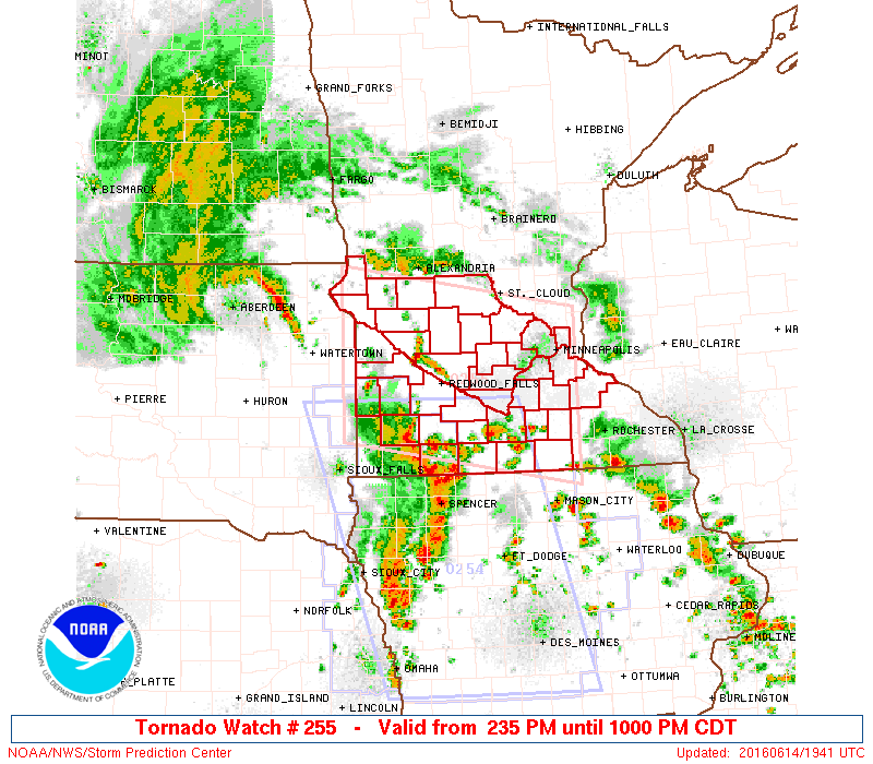
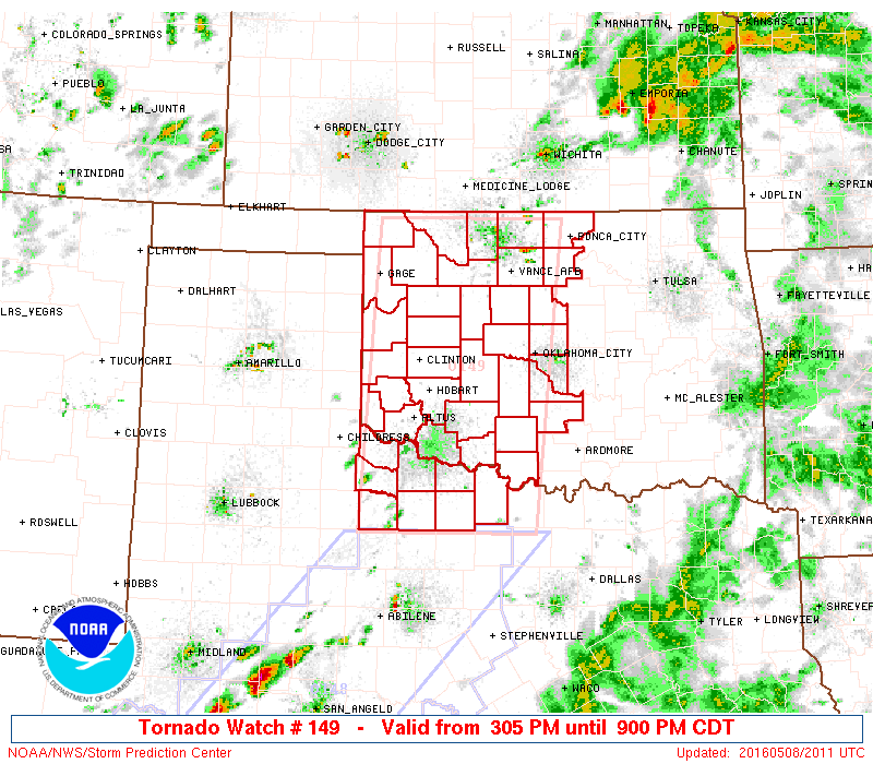
  Tornado watch issued at 2:25 PM CDT as storms are erupting right on the triple point.

mcd0685.gif

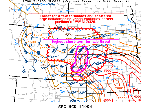
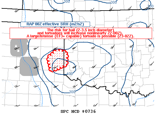
  Mesoscale discussion issued at 3:52 PM CDT, highlighting the continued risk for tornadoes with storms in northeast Iowa.

mcd0687.gif

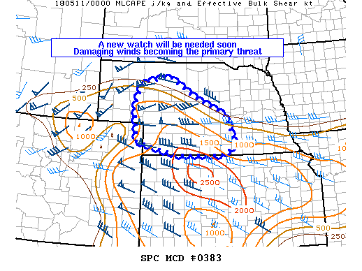
  Mesoscale discussion issued at 6:30 PM CDT indicating a new watch will likely be issued southeast of tornadic storms in northeast Iowa.

Severe Watch.JPG

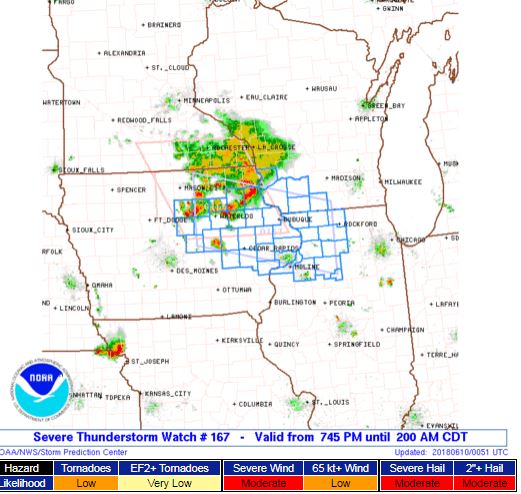
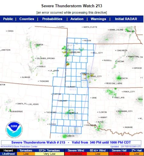
  Severe thunderstorm watch issued at 7:45 PM CDT as storms move downstream and evolve into severe wind and hail producers.

STORM REPORTS

180609_rpts_filtered.gif

STORM PREDICTION CENTER OUTLOOKS

Outlooks.jpg

JUNE 6, 2018 IOWA: SEVERE THUNDERSTORMS ALONG A STALLED BOUNDARY

  Took a few days to chase with Rich Hamel, who flew in from Boston.  After a bust in North Dakota the day before, we moved south to Iowa to chase storms along a stalled, outflow enhanced boundary that had dropped to just north of I-80.  There were not a lot of expectations on this day due to weak low and deep layer shear, but there was enough instability of 4,000 j/kg of MLCAPE to lead to severe thunderstorms producing damaging winds and large hail.  We caught the first severe storm just south of Ames, Iowa and then moved back west towards Guthrie Center as new storms developed.  Overall, the chase ended up near expectations considering the environment storms were going up in.

DSC_0417.jpg

  A old one room schoolhouse that was still in good shape near Slater, Iowa.  New flanking towers of our initial storm are going up behind the schoolhouse to the west.  We ended up chasing back west to these new storms.

DSC_0424.jpg

  2nd severe storm of the day near Panora, Iowa.  Core moving right to left in this image and new hail core opening up in the distance.

DSC_0426.jpg

  Closer view of the new hail core opening up near Panora, Iowa.

DSC_0431.jpg

  View of the updraft and vault region of our storm, about to move overhead.

DSC_0432.jpg

  Dark, high-based storm approaching us from the north with heavy rain and hail curtain.

  Rich Hamel in his element!

  Severe thunderstorm about to overtake us.  Dark, rolling shelf cloud on the leading edge of the storm.

mcd0652.gif

  Mesoscale Discussion issued at 2:22 PM CDT, highlighting the area that will most likely need a severe thunderstorm watch in 1-2 hours.

Watch Box.JPG

  Severe thunderstorm watch issued at 3:20 PM CDT.  Notice the High Likelihood for severe wind and hail.

mcd0655.gif

  Mesoscale Discussion issued at 6:20 PM CDT as severe thunderstorms are ongoing.  We were on the western end of that line of storms in central Iowa at this point.

mcd0657.gif

   Final Mesoscale Discussion issued at 8:45 PM CDT as thunderstorms are beginning to weaken.

STORM REPORTS

180606_rpts_filtered.gif

STORM PREDICTION CENTER OUTLOOKS

JUNE 1, 2018 NORTH DAKOTA: SEVERAL TORNADO WARNED SUPERCELLS AND A DISTANT TORNADO

  There were two targets today, one in Nebraska and another in North Dakota.  Decided on the northern target and took the long drive with Wes Hyduke out to western North Dakota to chase a triple point setup that offered decent tornado potential.  Shear and instability were maximized right on the triple point and warm front, so we had an initial target in the vicinity of New Town to Makoti.  Unfortunately, this was right on the north side of large reservoir Lake Sakakawea.  The front ended up not lifting as fast as forecast, so we set up shop on I-94 near Glen Ullin, watching towers go up and down during the mid-afternoon hours.  Storms finally went up right on the low and triple point along Hwy 85 to your northwest.  We headed up Hwy 8 towards Halliday as the storm became tornado warned, and ended up seeing a confirmed tornado from 19 miles away that was near the town of Medicine Hole.  Since the storms were moving northeast, we could not get across the reservoir due to being cut off, so proceeded up towards Two Buttes on a hill with a great view off Hwy 22.  Here is where we saw 4 separate tornado warned storms, each with wall clouds moving south to north right in front of us.  A few of these wall clouds had solid rotation and attempted to wrap up, but these eventually occluded before dropping a tornado.  After about 1 good hour of chasing, the storms became a severe cluster of storms producing wind and hail.

DSC_0319.jpg

  Looking to the southwest of Glen Ullin, North Dakota as updrafts were attempting to break the cap on the warm front as it was lifting north.  This area later had a storm that produced a brief tornado, close to where we were at this point!

DSC_0328-1.jpg

  Tornado from 19 miles away that was near Medicine Hole, North Dakota.  We were viewing from north of Halliday and trying to stair step northwest to get ahead of the storm at this point.

DSC_0328-2.jpg

  Closer view of the tornado near Medicine Hole, taken from a distance.

DSC_0336.jpg

  Set up shop east of Two Buttes on a large hill that had a great view to our west.  We could see 3 supercells at once from this spot, all that were tornado warned at some point.  Here is the 2nd supercell in the line coming up from the south with a visible wall cloud under the updraft.

DSC_0338.jpg

  Visible rotating wall cloud on a tornado warned storm looking to our west-northwest.

DSC_0341.jpg

  Wall cloud still present on the storm as it continued to slide off to the north.

DSC_0351.jpg

  The 3rd storm in the line that came up from the south.  Another lowering on this storm as well.

DSC_0355.jpg

  A 4th supercell getting its act together and moving up from the south.  I was just blown away by the view from this location.

DSC_0360.jpg

  Storm becomes tornado warned as a wall cloud forms on the northeast side of the base.  

DSC_0366.jpg

  Wall cloud becomes better organized here, with upward condensating motion into it.  Visible rotation at this time as well.

DSC_0367.jpg

  Closer shot of the wall cloud from the previous photo.

DSC_0372.jpg

  The closest that this storm came to producing a tornado.  Could not tell if there was a big cone funnel or tornado tucked away back there, surrounded by heavy rain and hail. 

DSC_0373.jpg

  Twin mesocyclones northeast of Two Buttes, North Dakota.  Great structure and foreground.

DSC_0380.jpg

  The 4th tornado warned storm of the day occurred as we headed east on Hwy 22 to keep ahead of the storms.  This was the last wall cloud we saw as the storms were really congealing into a severe cluster at this point.  

DSC_0385.jpg

  Closer shot of our last wall cloud of the day.  This one was on the messy side but was still tornado warned with some slower rotation.

DSC_0393.jpg

  Nice mammatus display covering the sky on the back side of the storms as we got back down to I-94 near Glen Ullin, North Dakota.

DSC_0394.jpg

  Punched through the squall line through North Dakota and got ahead near Jamestown.  It was completely dark at this point, but I caught a decent view of the storm with an 8 second shutter speed.

DSC_0396.jpg

  Looking to the south at the shelf cloud overtaking Jamestown, North Dakota.  The chase vehicle G6 is on the left with Wes in the passenger seat.

mcd0608.gif

  Mesoscale discussion issued at 2:13 PM CDT highlighting the severe weather potential with all hazards possible.  3,000 j/kg of MUCAPE nosing up into the area with 50 kts of effective bulk shear.

ww0146_radar_init_resize.gif

  Tornado watch issued at 3:20 PM CDT!

mcd0615.gif

  Another mesoscale discussion issued at 6:02 PM CDT, highlighting the greatest short term risk for tornadoes.  The tornado threat was quickly diminishing at this point as storms congealed, even in the presence of strong deep layer shear and moderate instability.

mcd0619.gif

  Yet another mesoscale discussion issued at 8:30 PM CDT highlighting the area of greatest severe weather risk.  This was as we were core punching through the storm to get ahead near Jamestown.

STORM REPORTS:

180601_rpts.gif

STORM PREDICTION CENTER 1630Z OUTLOOKS:

Outlooks.jpg

MAY 10, 2018 WYOMING & NEBRASKA STORM CHASE: SUPERCELLS, LANDSPOUT TORNADO, HAIL AND LIGHTNING SHOW

  Had a somewhat surprisingly good chase out to eastern Wyoming and western Nebraska.  2018 has been a big time down year for good storms and tornadoes, but we managed to get everything from great structure, big hail, a landspout tornado and a heck of a lightning show this day.  I probably would not have chased if my friends Kevin and Kate were not out on their chasecation and I could meet up with them in Wyoming.  I left the day before and drove out to Rapid City, South Dakota, then down to the target area near Cheyenne, Wyoming the next day.  We watched a short-lived supercell with terrific structure go up on the Laramie Range north of Cheyenne, but this storm quickly went outflow dominant with a surging boundary and cold front undercutting all the storms.  This was obviously the end to any decent thunderstorm threat that we had, so the decision was made to book it to the east towards storms developing in northeast Colorado and moving up towards Sydney, Nebraska.  Storms went to the north into an area of bad roads and into more stable air, but one storm caught our eye southwest of Ogallala, Nebraska.  We got ahead of this storm and almost decided to bail and head north to get on a storm approaching Arthur, Nebraska, but the storm to our southwest strengthened and started to look much better as it got into higher dewpoints and better CAPE.  Ended up chasing this storm from Ogallala to Wallace, Nebraska, seeing some good structure, a wall cloud, funnel, rainbow with lightning, a landspout tornado and an incredible lightning show to end the day.  Definitely worth the 1800+ miles that I drove on this trip, even for 1 day!  Drove back home the day after as the setup for the next few days did not look appealing to chase.

DSC_0086.jpg

  Beautiful supercell with foot shaped lowering and great structure moving off the Laramie Range to the north of Cheyenne, Wyoming.

DSC_0084.jpg

  Wide angle, zoomed out view of the entire rotating supercell moving off the Laramie Range into the high plains of Wyoming.  You can really see the inflow being pulled in with the bands from left to right and rising, corkscrew motion into the storm updraft.

DSC_0100.jpg

  Caught a photo of a train going by while watching the storm east of Ogallala, Nebraska.  Thought it was kind of a cool photo, especially since you can see the storm in the background through the train.  

DSC_0130.jpg

  Kevin and Kate enjoying the chase and watching the mesocyclone directly ahead of us north of Madrid, Nebraska.

DSC_0134-1.jpg

  Short lived funnel cloud on the storm north of Elsie, Nebraska.  

DSC_0148.jpg

  Wall cloud north of Elsie, Nebraska.  View from the east as the mesocyclone was moving towards us down the road.

DSC_0154.jpg

  Got into some big hail north of Elsie, Nebraska!  This was after 15 minutes of melting.  Around golf ball size hail initially.

DSC_0156-1.jpg

  Awesome shot of a rainbow and lightning in nearly the same orientation northwest of Wallace, Nebraska!  This was looking to the east at the back side of the storm.

DSC_0183-1.jpg

  Landspout tornado!  We came around a bend in the road and saw a large dirt plume.  No condensation funnel above but was rapidly rotating and swirling with dirt directly underneath the mesocyclone.  Very cool site to an already good chase day.

DSC_0189-1.jpg

  Another shot of the landspout tornado with lightning.  Lots of dirt being kicked up at this point.  Last moments of daylight here, or we would have never been able to see it clearly.

DSC_0199.jpg

  Time for lightning shots.  I really like how these bolts took on a similar shape, north of Wallace, Nebraska.

DSC_0201.jpg

  Bolts, bolts, bolts, everywhere!  This was on a 30 second exposure.  Lots of cloud to ground lightning as the storm remained severe.

DSC_0211.jpg

  Lightning snaking across the sky.

mcd0375.gif

  Mesoscale discussion issued at 12:56 PM MDT, highlighting the need for a watch box to be issued soon.  Storms expected to develop quickly in an environment characterized by 40 knots of effective bulk shear and 1,000 j/kg of MUCAPE.

Watch.JPG

  Severe thunderstorm watch issued at 1:40 PM MDT by SPC for southeast Wyoming and western Nebraska, mainly for the risk of large hail and damaging winds.

mcd0379.gif

  A new mesoscale discussion issued at 5:10 PM MDT, highlighting the continued severe weather threat.  Effective bulk shear has now increased to around 50 knots with 2,000 j/kg of MUCAPE into western Nebraska.

mcd0383.gif

  Mesoscale discussion issued at 7:39 PM CDT highlighting the need for another watch box soon, especially for damaging winds.  Effective bulk shear continues to increase to 55-65 knots into the area.

Watch2.JPG

  New severe thunderstorm watch issued at 8:00 PM CDT for severe storms with damaging wind potential into the evening.

STORM REPORTS:

180510_rpts.gif

STORM PREDICTION CENTER OUTLOOKS:

Untitled.jpg

JULY 11, 2017 NORTH DAKOTA & MINNESOTA: TORNADO & INTENSE SUPERCELL

  Chased a beast of a tornadic supercell out of eastern North Dakota into northwest Minnesota.  Witnessed a multiple vortex tornado between Hatton and Buxton, North Dakota before it wrapped back into the core and was not in view.  Thereafter, I stayed in or near the notch and thankfully had a good road network to do so as I stayed with the storm southeast into Minnesota, ending the chase near Ada.  The storm exhibited terrific supercell structure throughout its entire life cycle!  A textbook mothership.

Tornado!  Multiple vortex tornado between Hatton and Buxton, North Dakota.  Had to be right in the notch to view this as the tornado formed on the north side of the core as the wall cloud was wrapping back in.  This photo is out of sequence with the others below.  Wanted to show this first.

Storm starting to get organized with a lowering already forming near Northwood, North Dakota.

Supercell forming with wall cloud and inflow tail right to left into the base near Northwood, North Dakota.

Wall cloud tightening up with structure taking mothership appearance north of Hatton, North Dakota.

Beautiful supercell with tornado in progress on the right side of the core and terrific structure west of Buxton, North Dakota.

Multiple vortex tornado tucked away in there!  Roughly 1.5 miles west of my location between Hatton and Buxton, North Dakota.

Intense core approaching me from this mothership supercell.  Inflow tail present as moisture is being focused and drawn into the storm.

Another shot of the intense supercell approaching me near Buxton, North Dakota.  Tornado is occurring at this time but cannot see it due to being shielded by the rain and hail core.

Textbook supercell here with big wall cloud on the right side of the core underneath the updraft vault.

All you can say is WOW!

Multiple inflow bands as rich moisture in the low and mid levels is being drawn into this storm near Shelly, Minnesota.

Looks like the mothership is coming in for a landing!

Awesome storm near Shelly, Minnesota as I got 5 miles out ahead to get a better shot of the structure.

Intense mothership supercell after producing a tornado near Buxton, North Dakota.  This was as the storm was nearing the river crossing into Minnesota near Shelly.

A mean looking storm, still tornado warned near Ada, Minnesota.

Storm starting to become more outflow dominant with wicked shelf cloud near Ada, Minnesota at the end of the chase.  Chased this storm for 5 hours!

STORM PREDICTION CENTER OUTLOOKS

Mesoscale Discussion issued at 3:48 PM showing favored areas for initiation of thunderstorms between 21-23Z (4-6 PM).

ww0408_radar_init.gif

Tornado watch issued at 4:40 PM for eastern North Dakota and northwest Minnesota.  Valid until 11:00 PM.

New mesoscale discussion issued at 7:09 PM showing the area of greatest tornado risk along the warm front and old stationary boundary near Grand Forks and areas south to Fargo, North Dakota, right where the supercell I was one was tracking and producing tornadoes.

Severe thunderstorm watch issued at 10:00 PM for all of central Minnesota as the thunderstorms formed an intense cluster moving southeast and producing damaging winds.

Mesoscale discussion issued at 1:49 AM as the thunderstorms continued to progress southeast and produce damaging winds, eventually reaching my house near the Twin Cities and moving east.

STORM REPORTS

JUNE 29, 2017 NEBRASKA & IOWA SUPERCELL: GOOD STORM STRUCTURE

  Chased a supercell thunderstorm out of northeast Nebraska through Sioux City, Iowa where it produced baseball size hail, and into northwest portions of Iowa.  This storm was tornado warned near Sioux City before becoming outflow dominant and producing a spectacular shelf cloud near Mapleton, Iowa.  The storm had some really good structure for a while (see photos below).  The video is primarily a time-lapse from two different segments of the storm.

Terrific storm structure near Mapleton, Iowa at the end of the chase.  This photo is out of sequence with the others below.

Storm was tornado warned at this point, directly over Sioux City, Iowa.  This area in the center of the image was the action area where there was notable rotation and a ragged, somewhat high-based wall cloud.

Another shot of the wall cloud only a few miles south of Sioux City, Iowa.  This was taken looking northeast.  I quickly had to drive back into the core on the left side of this image to get across the Missouri River to get ahead of the storm into Iowa.  I encountered quarter-size hail and thankfully missed the baseball hail that was reported in Sioux City.

Wall cloud on the tornado warned storm near Owego, Iowa.  This was as close as this storm came to producing from my vantage point.

Storm now becoming outflow dominant and forming a shelf cloud near Smithland, Iowa.  Lots of mid-level inflow bands still occurring into this storm here.

Another shot of the storm east of Smithland, Iowa as the shelf cloud became more prounounced.

Short time later as the shelf cloud approached.

Was interesting how a part of this shelf started to take on a different shape here.  There was solid inflow occurring on the right side into this base...almost looked like a wall cloud attempting to form.  Indicated storm may not be true outflow dominant here and was trying to focus an area of rotation with this lowering.

Southern end of the shelf cloud, but still can see a few locations where inflow may be occurring in the notches.

Shelf cloud approaching.  Like that wavy appearance to the striations above the shelf.

STORM PREDICTION CENTER OUTLOOKS

Mesoscale Discussion issued at 2:26 PM CT highlighting a likely severe thunderstorm watch upcoming.  Storm I chased was on the warm front ahead of the triple point.

Severe thunderstorm watch issued at 3:40 PM CT until 11:00 PM CT across eastern Nebraska and western Iowa.

STORM REPORTS

JUNE 22, 2017 NORTHERN IOWA: TERRIFIC SUPERCELL STORM STRUCTURE

  Took a trip down to Iowa with my wife, MaryLynn, to see the Bridges of Madison County, see other sites, and then chase some storms.  There was not a lot of expectations on this day with limited deep layer shear and instability, but storms were likely to form on and ahead of the cold front in an environment that had been worked over some by rain and storms early in the day.  A storm that did form in northern Iowa somewhat surprisingly became a supercell and took on terrific structure during the early to middle part of its life cycle.  This was the one good storm of the whole event and one of the few that became severe thunderstorm warned, as it formed and tracked along a remnant outflow boundary and cold front intersection.  There was never a severe thunderstorm or tornado watch issued for the area as any severe storms were limited in coverage.

My favorite shot of the day of the incredible storm structure and striations with fully established shelf cloud near Hansell, Iowa.  Photo out of sequence from the others below.

DSC_0381.jpg

Multiple inflow tails to the base as we approached from the north near Meservey, Iowa.

Got a little closer and I was surprised at the well developed wall cloud that had formed on the southeast side!  Clearly can see the multiple inflow bands and I think the band of clouds right in front of us in this image is the actual outflow boundary the storm was rooted on.

Extremely low cloud base on this storm.  Looking west from near I-35 southeast of Meservey, Iowa.  The storm lost the wall cloud here but was still showing signs of strong inflow and rotation in a few spots.

Intense rain and hail core between Meservey and Chapin, Iowa.  Storm is severe thunderstorm warned at this point.

Awesome shelf cloud on the storm near Chapin, Iowa.

Looking the other direction from the previous image, to the north as the core of the storm was approaching.  Still some inflow into this storm as you can see from the bands on the left side.

Shot of the storm between Chapin and Hansell, Iowa with grain bins in the foreground and shelf cloud about to overtake.

Unreal structure near Hansell, Iowa!

Looking northeast at the vault region of the storm and shelf cloud at the base.

Storm looking mean as it gets near.

STORM PREDICTION CENTER OUTLOOKS

Mesoscale Discussion issued by SPC at 9:09 PM CDT as isolated severe thunderstorms were ongoing along the front.  They did not analyze the outflow boundary through north-central and northeast Iowa, but there appeared to be one there.  Never did issue a severe thunderstorm watch since the storm coverage was low.

STORM REPORTS

JUNE 15, 2017 KANSAS SUPERCELL & CORE PUNCH

  Chased as a guide with Silver Lining Tours (http://www.silverliningtours.com/) on this trip.  Got on a developing storm from the first updraft and followed it throughout its maturation cycle  from near Hays, Kansas southeast to near Newton.  The storm was tornado warned much of the time and exhibited terrific structure initially, producing baseball size hail in Hays, and morphed into a dangerous squall line producing damaging winds near 70 mph later in its life cycle.  The video shows a few time lapse segments from this storm, followed by our core punch through the squall line at the end of the chase.

Focused gustnado on the leading edge of the outflow and shelf cloud.  This was called in as a tornado by other chasers but appeared to be a gustnado over a tornado from our vantage point.  Gustnadoes are much weaker and produced differently than tornadoes, but can still kick up a lot of dirt!  This photo is out of sequence with the others below.

Supercell in early stages south of Hays, Kansas.  Lowering and brief funnel cloud in this image formed on the left side of the core.

Zoomed out view of the previous image, showing the brief funnel left of the core and supercell taking on very good structure.

Awesome structure with intense core/microburst occurring, and storm starting to go outflow dominant in central Kansas.

Right side of the core as supercell is going outflow dominant.  We are positioned southeast of the storm with storm motion being to the southeast towards us.

Group of Silver Lining Tours guests enjoying the view of an intense supercell storm near Hoisington, Kansas.

Still some inflow occurring on the northeast side of the intense rain & hail core over the open prairie of central Kansas.

Just another shot of the previous gustnado image a few moments later.

Gustnado washing out here but can still see the debris plume on the leading edge of the outflow winds on the left side where the gustnado was focused.

Severe thunderstorm moving towards us.  Stopped to get a shot of the storm as a backdrop to the limestone fence posts.  As you can imagine, there were not a lot of trees on the prairies of Kansas so, when these fences were built, they used limestone rock for posts since this was more readily available.  Cool to see these scattered about the countryside.

Mammatus clouds ahead of the storm to the east of Great Bend, Kansas.

Looking northwest at the approaching storm over a Kansas wheat field.

STORM PREDICTION CENTER OUTLOOKS

Mesoscale Discussion issued by the Storm Prediction Center at 12:49 PM CDT, outlying the risk area for an upcoming Severe Thunderstorm Watch.

Severe Thunderstorm Watch issued for central and eastern Kansas at 1:25 PM CDT.  This is the area highlighted for expected wind gusts of 60-80 mph.  You can see our storm just getting going southwest of Hays, Kansas.

Another Mesoscale Discussion issued at 3:29 PM CDT, highlighting the environment our storm was moving into and the possibility of 60-80 mph winds as the storm started to bow out into an intense line.

Another Mesoscale Discussion is issued at 5:58 PM CDT as the threat of damaging winds continues with the storms forming a bowing line.

A new Severe Thunderstorm Watch issued at 7:05 PM CDT ahead of the bowing line forming a severe MCS (mesoscale convective system).

STORM REPORTS

JUNE 13, 2017 SOUTH DAKOTA: SUPERCELLS & GUSTNADOES

  This was the third day of chasing as a guide for Silver Lining Tours (http://www.silverliningtours.com/).  The day before, we caught 3 brief tornadoes and a beast of a storm in Wyoming and Nebraska.  We got ahead of this same system near the South Dakota/Nebraska border area on this day.  The thought was storms would form off the cold front/dryline and be rotating supercells with a decent chance to produce a tornado, although temperature/dewpoints spreads were fairly large.  A second target existed on the warm front across northeast South Dakota into west-central Minnesota but we thought the storms here would be too messy and congeal too quickly to stray from our closer target.  There did end up being a nice tornado in that second target area across west-central Minnesota.  We managed to catch a few severe and tornado warned supercells, as well as several gustnadoes on our storms.  There were a few tornado reports from the storms we were on, but we could not confirm that these were tornadoes over gustnadoes. 

First arriving on the supercell with a wall cloud near Bonesteel, South Dakota.  Storm had some decent structure at this point.

  Looking at the northern side of the base and updraft with the core of the storm on the right and wall cloud on the left.

  Cool shot of the approaching storm and a grain silo in the foreground.  

Looking west towards the approaching supercell near Pickstown, South Dakota.  This is the spot where I shot the time-lapse video above.

Gustnado occurring down the road from our location on the bottom right of the image.  Storm core coming in from right to left along with the shelf cloud.

Another shot of the storm and gustnado that is was producing near Wagner, South Dakota.  This was called in as a tornado by multiple sources but appeared to be a gustnado to me due to outflow of the storm and no condensation funnel above.

Looking at a tornado warned storm to the west, while the tour group enjoys the spectacle.

Rainbow on the backside of a different storm as we were getting close to sunset.  A few of the guests caught lightning and this rainbow in their shots.

At sunset on the back of the storm, looking southwest.  Cool looking sky with good color, mammatus clouds and the shot of an anvil from another storm in the distance.  

Terrific looking sky at sunset looking west in northeast Nebraska.

STORM PREDICTION CENTER OUTLOOKS

Mesoscale Discussion issued by SPC at 2:32 PM CDT, highlighting the threat for storms to develop by 21Z with primary threats being wind damage and hail, along with some tornado threat.

Tornado Watch issued at 3:15 PM CDT for the area, valid until 10:00 PM CDT.

Another Mesoscale Discussion issued at 3:46 PM CDT from eastern Nebraska into southeast South Dakota and northwest Iowa.  Additional storms expected to form ahead of the initial storms that we were chasing along the South Dakota/Nebraska border.

A Mesoscale Discussion issued at 5:43 PM CDT as intense storms were maturing and new storms started to fire on the warm front and ahead of the low on the triple point.

Mesoscale Discussion issued at 8:34 PM CDT for the storms that were congealing and becoming less discrete across the eastern Dakotas into eastern Nebraska and western Minnesota.

STORM REPORTS

JUNE 12, 2017 WYOMING & NEBRASKA CHASE: 3 TORNADOES & BEASTLY SUPERCELL AT DUSK

  I was chasing as a guide for Silver Lining Tours (http://www.silverliningtours.com/) for this one.  We had high hopes that this would be the best chase of the tour as conditions were ripe for rotating supercells and tornadoes.  A trough was ejecting out of the Rockies and into the northern High Plains, with more than sufficient low and deep layer wind shear.  Bulk shear as in the area of 65 knots.  A nose of 3,000-4,000 J/KG of MLCAPE developed into western Nebraska and eastern Wyoming, allowing for a very unstable airmass.  Shear, lift, instability and moisture appeared sufficient for a tornado outbreak to occur.  We ended up seeing 3 brief tornadoes on the day, only one shown below and in the video from a distance.  I was driving during the other 2 tornadoes.  The first supercell that we chased was from near Chugwater, Wyoming to Torrington, Wyoming.  The second supercell became large, photogenic and very intense.  We chased this storm from near Bayard to Alliance, Nebraska.  

Storm looking even more amazing as it approached our location.  Love those stack of plates!  This photo is out of sequence with the others.

First storm of the day exploding on the mountains to the west of Chugwater, Wyoming.  Wall cloud already developing on the left side of the core.

Wall cloud trying to organize to the east of Slater, Wyoming.  Moderately fast inflow occurring from right to left into this base.

Another wall cloud in the foreground trying to organize.  Large, low-hanging rising scud bomb in the distance being pulled into the base and around the wall cloud.  This was near Rockeagle, Wyoming.

Wall cloud tightening up and spinning near Rockeagle, Wyoming, shortly after the previous image.

Had a bad road network here, so only could capture this tornado from a distance as we looked west from near Lingle, Wyoming.

Multiple low inflow bands pulling in rich moisture with the second supercell we chased near Bayard, Nebraska.  A short time before, this the storm developed two brief tornadoes.  I was driving the van at that point and not able to capture a photo.

Awesome mothership structure, stacked plates, and shelf cloud on the storm as it became high precipitation (HP) near Angora, Nebraska.

Mothership about to engulf a train between Angora and Alliance, Nebraska.

Storm spitting out lightning left and right as it was about to overtake us.  Had to get out of the way shortly after this as the storm had huge hail within the core.

Another shot of the lightning and mothership supercell south of Alliance, Nebraska towards sunset.

Plenty of cloud-to-ground lightning to go around!  Was popping lightning all over the place and the storm was very intense at this point.  Tornado warned with a considerable couplet on radar embedded in the high precipitation monster.

Another shot of the lightning at dark.  Had to get out of the way shortly after this photo as it was a very dangerous, intense supercell.

STORM PREDICTION CENTER OUTLOOKS

Mesoscale Discussion issued at 11:29 AM MDT, already talking about issuing a tornado watch as thunderstorms develop over the next few hours.

Tornado Watch issued at 1:10 PM MDT, valid until 8:00 PM MDT.

New mesoscale discussion issued at 5:05 PM MDT for the area with greatest risk for strong tornadoes and all severe weather hazards.

Mesoscale discussion issued at 8:02 PM MDT as dangerous supercell thunderstorms continued to move northeast through Nebraska, western South Dakota and northeast Wyoming.

STORM REPORTS

MAY 16, 2017 TEXAS & OKLAHOMA STORM CHASE: TORNADOES & INCREDIBLE LIGHTNING

  This was the day we had been waiting for and the reason for the whole trip.  An upper trough was ejecting out into the Plains with strong 55-65 knot winds at 500 mb, amble moisture, instability and strong wind shear to allow for rotating supercells and tornadoes.  Wes Hyduke and I left Garden City, Kansas late morning and made our way down to west of McLean, Texas off I-40 to get in position.  We encountered 3 separate supercell storms, starting near McLean, Texas and ending near Sentinel, Oklahoma.  The McLean storm produced a photogenic tornado, while the storm near Sayre, Oklahoma had a tornado debris spin-up underneath the bowl lowering and mesocyclone.  This second storm is the one that brought the big rain-wrapped tornado that led to extensive damage in Elk City, Oklahoma.  This was followed by a spectacular cloud-to-ground lightning show near Gotebo, Oklahoma.  A great chase day!

Awesome elephant trunk tornado near McLean, Texas.  We stopped next to a Doppler on Wheels truck to view the tornado in the distance as it was churning away.  This photo is out of sequence with the others below.

Wall cloud on the first tornado warned storm of the day near the Gray County Rest Area, to the west of Alanreed, Texas.

Wall cloud on a second tornado warned storm east of Howardwick and south of Alanreed.  Taking on terrific structure at this point with inflow tail on the right into the base and condensating wall cloud.  This was the storm that produced the tornado near McLean a short while later.

WE'VE GOT COWS!  Had to evade a herd of cattle on dirt road 20 south of Alanreed and northeast of Clarendon, Texas.  Was a funny moment when we were trying to get in position to intercept a tornado warned storm heading towards McLean.

Approaching the tornado warned storm southwest of McLean, Texas on highway 273.  Wall cloud with large inflow tail right to left into the storm.  

Radar grab showing our location close to the time the previous photo was taken.

TORNADO!  Beautiful elephant trunk to rope tornado south of McLean, Texas as we were driving north on highway 273.

We drove up highway 273 towards McLean and looked off to the left to see the tornado still going strong!  I am still not sure if this was a second tornado or in the roping out stage of the first tornado.  Could have rotated around the mesocyclone and back west.  Appeared to me to be a 2nd tornado on a new updraft off the dryline well to the west of the first tornado, but cannot be sure.

A zoomed in view at the base of the tornado south of McLean, Texas.  There was decent rotation at the base of the tornado towards the end of its life cycle but it did not appear to be violent.

Tornado in roping out stage towards the end of its life-cycle.

Rainbow below and exploding supercell updraft as we approached a new storm northeast of Vinson, Oklahoma.

One of the best inflow tails that I have ever seen.  This thing was like a conveyor belt of warm, moist air into the storm base and shooting directly into the updraft.  Near Sayre, Oklahoma.

Another tornado spinning up dirt directly underneath a fast spinning mesocyclone near Sayre, Oklahoma.  A beautiful storm at this point!  Thought this was going to drop a big multiple vortex tornado right in front of us, but it never grew beyond this.

Awesome storm structure with beaver tail, wall cloud, quickly rotating mesocyclone and dusty tornado underneath near Sayre, Oklahoma.

Had to get a photo in front of this storm!  It had everything.

A short while later as the mesocyclone was approaching.  Still a fast rotating wall cloud, somewhat rain-wrapped, and producing funnel after funnel.

Meso really getting close at this point.  Strong rotation and funnel very close to the ground.  May have touched down again here but not for certain.  Still southeast of Sayre and west of Carter, Oklahoma.

Very close to producing a tornado here.  Strongly rotating wall cloud and funnel.  This is looking directly into the notch from the northeast side near the forward flank core.  Had to get out of here shortly after this photo was taken.  The storm later went on to produce a large tornado that hit Elk City, Oklahoma.

Ended the day with a terrific cloud to ground lightning show near Gotebo, Oklahoma.

UNREAL lightning strike that occurred directly in front of our car and right in the middle of my camera frame!  Probably will never get a lightning shot even comparable again in my lifetime.  Fortunately, I was in the car and had a remote trigger for my camera, which was outside on a tripod.  Camera settings were ISO 100, f/22, and 20 second exposure.

STORM PREDICTION CENTER OUTLOOKS

Mesoscale discussion issued at 1:19 PM making note of the tornado watch that will be issued shortly.

Particularly Dangerous Situation (PDS) tornado watch issues at 1:50 PM until 10:00 PM CDT.  Note the high likelihoods for tornadoes, wind and hail.  

New mesoscale discussion issued at 4:56 PM, highlighting the small area where tornado risk would be greatest as well as extremely large hail.  This area highlighted was where the 2 storms in which we saw tornadoes were located.

Another mesoscale discussion issued at 7:29 PM, highlighting a continued tornado risk east of where the current tornado watch was in place.

STORM REPORTS

MAY 15, 2017 KANSAS STORM CHASE

  Wes Hyduke and I left Minnesota on this morning and drove to northwest Kansas where we intercepted a couple of photogenic supercell thunderstorms.  This chase was primarily by chance as we were on our way to chase in the Texas Panhandle the next day.  We decided to take a detour to view the storms in northwest Kansas and glad that we did.

Captured a cloud-to-ground lightning strike out of the storm as we watched from the southeast side.  This photo is out of sequence with the others below.

Terrific mammatus display on the storm as we approached near Hill City, Kansas.

Looking directly upwards at the mammatus clouds under the anvil on the storm west of Hill City, Kansas.

The storm started to get some decent structure near Hoxie, Kansas.  I love chasing in the wide open Plains!

Looking at the storm updraft and inflow bands feeding into it near Hoxie, Kansas.  Severe thunderstorm at this point.

Great structure on the storm at this point but storm starting to congeal and become more of a cluster.

A left-moving low precipitation supercell north of Garden City, Kansas at the end of the day.

STORM PREDICTION CENTER OUTLOOKS

MESOSCALE DISCUSSION ISSUED FOR THE AREA AT 3 P.M. CT.

Severe Thunderstorm Watch Issued at 3:40 PM

STORM REPORTS

JUNE 19TH MINNESOTA: TORNADO WARNED SUPERCELL

 
DSC_0381
DSC_0381

Intercepting a tornado warned supercell west of Lake Shore at the intersection of Cty Rd 1 and 88th St.  Nicely structured storm with inflow streamers, large base and wall cloud.  The lowering/wall cloud was tough to make out until the storm got closer due to being shielded by rain.

DSC_0382
DSC_0382

Looking a bit to the right of the base and updraft at the intense core that went on to produce baseball size hail near Nisswa.

DSC_0385
DSC_0385

A closer view of the wall cloud west of Lake Shore, Minnesota. There was clear rotation at this point and fairly fast condensation into the base.

DSC_0387
DSC_0387

Wall cloud started to become more ragged as it approached my location but still evident tucked in right by the core and underneath the base.

DSC_0389
DSC_0389

Wall cloud forming over North Long Lake to my east.  This is where I came across a vehicle that was down in the ditch and backwards, close to the lake.  I checked on him and the guy was ok and had already called for help.

DSC_0392
DSC_0392

Wall cloud becoming better organized east of North Long Lake as I watched to the west.  Attempted to catch up with the storm right after this but got slowed going through Brainerd.

DSC_0398
DSC_0398

View of the strong and still tornado warned high precipitation (HP) supercell moving north of Mille Lacs Lake. This was taken in Garrison looking northeast.

DSC_0399
DSC_0399

Double rainbow north of Ogilvie, Minnesota.  WHOA, A DOUBLE RAINBOW!!

DSC_0410
DSC_0410

Base of the former tornado warned storm, and lightning, near Big Lake, Minnesota at the end of the day.

MESOSCALE DISCUSSION:

MN MD
MN MD

SEVERE THUNDERSTORM WATCH:

ww0273_radar_init
ww0273_radar_init

STORM REPORTS:

160619_rpts_filtered

SPC OUTLOOKS:

day1otlk_20160619_1630_prt
day1probotlk_20160619_1630_hail_prt
day1probotlk_20160619_1630_torn_prt
day1probotlk_20160619_1630_wind_prt

JUNE 14TH MINNESOTA: NUMEROUS FUNNEL CLOUDS & 2 TORNADOES


Longer version featuring highlights from the entire chase:

DSC_0227
DSC_0227

Wall cloud lowering on the first storm near Arco, Minnesota.  This cell did not look like much on radar but was spinning like mad and had solid inflow!

DSC_0231
DSC_0231

First funnel cloud of the day on the storm near Arco, Minnesota.  This storm produced several more funnels.

DSC_0254
DSC_0254

Another funnel that was rapidly rotating and condensing near Porter, Minnesota.  This funnel was 3/4 of the way to the ground but we cannot confirm there was any touchdown in the field right in front of us.  I believe we were on Highway 7 to the south of Porter at this time.

DSC_0263
DSC_0263

Another view as the storm moved just to our north and the wall cloud was really tightening up with a continuous funnel cloud.  The wall cloud occluded soon after this as the funnel dissipated.

DSC_0268
DSC_0268

Took a little while but we eventually got on the next storm after the first one died.  This wall cloud was forming with apparent inflow scud fingers near Big Stone Lake on the Minnesota/South Dakota border.

DSC_0273
DSC_0273

Another wall cloud quickly forming on the storm southeast of Beardsley, Minnesota.

DSC_0283
DSC_0283

Another funnel cloud quickly formed and dissipated on the storm.  Very high sheared air feeding these storms at this point but not a lot of instability.

DSC_0293
DSC_0293

The most pronounced and lowest funnel cloud of the day that did not produce a tornado.  Never could see if this touched down but it had to be close.

DSC_0311
DSC_0311

Hard spinning storm updraft and developing funnel cloud southeast of Beardsley and southwest of Barry, Minnesota.  Strong inflow occurring at this point.

DSC_0333
DSC_0333

Funnel cloud forming out of the hard spinning and tightening wall cloud shortly after the previous photo.  A textbook scenario of fast inflow to the right wrapping into the notch and rear flank downdraft winds cutting around the backside of wall cloud/updraft to eventually produce a beautiful tornado.

DSC_0355
DSC_0355

Rope funnel cloud starting to condense to the ground as the storm was moving north of our location.

Beardsley MN Tornado

Video still of tornado and white debris cloud.

Beardsley MN Tornado 2

Another video still showing stretching vorticity in action!  Long, white rope tornado.

Beardsley MN Tornado 3

Another video still of the long tube.

MESOSCALE DISCUSSION:

MN MD
MN MD

TORNADO WATCH:

ww0255_radar_init
ww0255_radar_init

STORM REPORTS:

160614_rpts_filtered

SPC Outlooks

Outlooks
Outlooks
 

MAY 8TH OKLAHOMA: TORNADO WARNED SUPERCELL & ROTATING WALL CLOUDS

 
DSC_0056
DSC_0056

Developing storm in the foreground with beautiful crepuscular rays coming through the clouds.

DSC_0060
DSC_0060

First developing storm north of Woodward, Oklahoma.

DSC_0065
DSC_0065

Wall cloud/lowering on the storm as it was starting to get its act together near Freedom, Oklahoma.

DSC_0067
DSC_0067

Rotating wall cloud underneath the updraft of the storm west of Alva, Oklahoma.

DSC_0068
DSC_0068

Another view of the condensing, rotating wall cloud.

DSC_0072
DSC_0072

Strong updraft as the storm reaches its strongest point.

DSC_0073
DSC_0073

New wall cloud forming after the old one weakened and occluded.

IMG_3986
IMG_3986

iPhone shot of the wall cloud west of Alva, Oklahoma.

DSC_0077
DSC_0077

Doppler on Wheels (DOW) heading down the road to re position as the wall cloud we were watching weakened and dissipated.

DSC_0080
DSC_0080

Strongest rotation of the day on this wall cloud that was tightening up near Alva, Oklahoma.  This likely would have produced a tornado at this point if the dewpoints were higher than the lower to middle 60s.

DSC_0085
DSC_0085

Condensing lowering on the wall cloud, possibly funnel.  Very tilted updraft from left to right on this storm.

IMG_3987
IMG_3987

My position (blue crosshairs) relative to the hook echo north of Alva, Oklahoma.

MESOSCALE DISCUSSIONS:

OK MD
OK MD
OK MD 2
OK MD 2

TORNADO WATCH:

ww0149_radar_init
ww0149_radar_init

STORM REPORTS:

160508_rpts
160508_rpts

SPC OUTLOOKS:

day1otlk_20160508_1630_prt
day1probotlk_20160508_1630_hail_prt
day1probotlk_20160508_1630_torn_prt
day1probotlk_20160508_1630_wind_prt

MAY 7TH COLORADO: SUPERCELL & FUNNEL

 
DSC_0040
DSC_0040

Supercell storm intensifying and still south of the warm front near Abarr, Colorado.

DSC_0041
DSC_0041

Wall cloud developing on the storm.  Notice clear slot behind the wall cloud where the rear flank downdraft cut was occurring.

DSC_0043
DSC_0043

Another shot of the storm as it was getting closer.  Sharp, flat base to the supercell at this point.  Dissipating wall cloud on the far right.

DSC_0047
DSC_0047

Silver Lining Tour guests and crew enjoying the show underneath the mammatus clouds.

DSC_0050
DSC_0050

Large storm base really taking on a C shape as the RFD cut became larger.

DSC_0054
DSC_0054

The storm near Vernon, Colorado as we began departing for Oklahoma City.  This storm went on to produce several tornadoes that we missed due to having to be back in Oklahoma City that night.

MESOSCALE DISCUSSION:

CO MD
CO MD

TORNADO WATCH:

ww0143_radar_init
ww0143_radar_init

STORM REPORTS:

160507_rpts
160507_rpts

SPC OUTLOOKS:

day1otlk_20160507_1630_prt
day1probotlk_20160507_1630_hail_prt
day1probotlk_20160507_1630_torn_prt
day1probotlk_20160507_1630_wind_prt

May 6TH WYOMING: SUPERCELL TIME LAPSE

 
DSC_0008
DSC_0008

Supercell storm rolling off the Laramie Range near Chugwater, Wyoming.  You can see the feeder bands from all directions into this storm.  Pulling in all the moisture that it can, considering dewpoints were only in the middle 40s.

DSC_0020
DSC_0020

Nicely structured mothership supercell over the foothills of the Laramie Range in Wyoming.  You can see how this storm is rotating with the clouds twisting into the updraft.

DSC_0025
DSC_0025

Another shot of the supercell as it was starting to move out over the flatter Plains near and east of Chugwater.  Storm starting to weaken some at this point.

DSC_0031
DSC_0031

Storm weakening but holding onto some good structure with well defined high-based inflow bands and storm base.

DSC_0033
DSC_0033

View of the storm as another core was starting to open up right in front of us.  Was popping some cg lightning with this new core but could not capture any of the lightning in a photo.

STORM REPORTS:

160506_rpts
160506_rpts

SPC OUTLOOKS:

day1otlk_20160506_1630_prt
day1probotlk_20160506_1630_hail_prt
day1probotlk_20160506_1630_torn_prt
day1probotlk_20160506_1630_wind_prt

April 26TH KANSAS: SUPERCELL & ROTATING, TIGHT WALL CLOUD

 
DSC_0788
DSC_0788

Initial wall cloud on the first tornado warned storm near Caldwell, Kansas.

DSC_0794
DSC_0794

Funnel on the first tornado warned storm just to the north of Caldwell, Kansas near the Oklahoma border.  This funnel persisted for a few minutes before dissipating.

DSC_0814
DSC_0814

Rotating wall cloud tightening up into a funnel near Mayfield, Kansas.  Nearly produced a tornado at this point!

DSC_0815
DSC_0815

Zoomed out view of the tightened up rotating wall cloud and funnel near Mayfield, Kansas.  This area of focused rotation dissipated after the occlusion.

DSC_0823
DSC_0823

This scared dog jumped in the through the passenger door and into the driver's seat when we weren't looking, ha ha!!  Poor guy...felt bad kicking him out in the rain but couldn't take him with.

DSC_0839
DSC_0839

Severe thunderstorm over the wheat fields of southern Kansas.   Storm starting to become outflow dominant and form a shelf cloud at this point.

DSC_0866
DSC_0866

Shelf cloud and storm about to overtake us and a train near Wellington, Kansas.

DSC_0871
DSC_0871

Looking at the underside of the shelf cloud, whale's mouth, as it passed over near Wellington, Kansas.  Visually striking blue/green/aqua colors under this shelf.

IMG_3218
IMG_3218

Wes Hyduke's panorama of the underside of the shelf cloud at the end of the day near Wellington, Kansas.

MESOSCALE DISCUSSIONS:

ks MD
ks MD
OK MD
OK MD

TORNADO WATCHES:  

ww0108_radar_init
ww0108_radar_init
ww0109_radar_init
ww0109_radar_init

STORM REPORTS:

160426_rpts_filtered

SPC OUTLOOKS:

day1otlk_20160426_1630_prt
day1probotlk_20160426_1630_hail_prt
day1probotlk_20160426_1630_torn_prt
day1probotlk_20160426_1630_wind_prt

MARCH 23RD MISSOURI & IOWA: SEVERE THUNDERSTORMS

 
DSC_0726-2
DSC_0726-2

Inflow tail into the storm near Westboro, MO.

DSC_0731-2
DSC_0731-2

Caught a lightning strike in the intensifying storms near Westboro, MO.

DSC_0737-2
DSC_0737-2

Storm from above, now severe warned, dumping a hail core.

DSC_0741-2
DSC_0741-2

Ragged lowering at the base of the storm at the Hwy C and 59 intersection.

DSC_0744-2
DSC_0744-2

Rain/hail cores on severe warned storms east of Westboro, MO.

DSC_0746-2
DSC_0746-2

Storms becoming more organized and showing several feeder bands near Blanchard, IA.

DSC_0754-2
DSC_0754-2

Another shot of the severe warned storms just south of Blanchard, IA.

DSC_0756-2
DSC_0756-2

The southern storm in the line coming up at me with high base forming on the southeast side.

mcd0252
mcd0252

Mesoscale discussion issued during the early afternoon.  Hilarious they put a 'wedge-shaped area' in the discussion!

ww0051_radar
ww0051_radar

Tornado watch issued at 3 PM for the area.

SPC OUTLOOKS:

day1otlk_20160323_1630_prt
day1probotlk_20160323_1630_torn_prt
day1probotlk_20160323_1630_hail_prt
day1probotlk_20160323_1630_wind_prt

STORM REPORTS:

160323_rpts_filtered

MARCH 23, 2016 CHASE LOG: MISSOURI & IOWA

  I decided to chase this day, mainly to kick off the rust from my last chase on July 12, 2015 and to see some decent thunderstorms after the long winter season.  The set-up included a strong upper level trough going positive to negative tilt by later in the day, a 100 kt 500mb jet streak from Kansas into Iowa, and effective shear of 40-50 kts.  At the surface, a surface low moved from near north-central Kansas to southeast Nebraska with a trailing dryline to the south and a near stationary warm front through the southern tier of counties in Iowa.  The plan was to target storms that were expected to develop near and just south of the triple point by 21Z (4pm).  The main concerns for the day were the dewpoints only projected to get into the 52-55F range and be relatively confined to a shallow layer with dry air aloft, and the other concern having to drive back through a blizzard on the northern end of this system in northern Iowa and southern Minnesota.

I left that morning and headed south on I-35 to I-80 west, then south on Hwy 148 to Corning and eventually making my way down Hwy 71 to Clarinda.  I stopped here to take a look at the data and grab a bite to eat.  Realizing that storms were likely to first fire in southeast Nebraska and build to the southeast, I headed further west to Shenandoah to wait for initiation, as the town was right on the boundary and wobbling between temperatures from near 60F to lower 70s.  A tornado watch was issued at 3pm for the area, valid until 10pm that evening.  I was honestly a bit surprised with the tornado watch being issues as I had thought a severe thunderstorm watch would be issued instead due the moisture quality issues into the area.

Storms first fired to the west right on the north and east side of the low.  I waited for additional storms to begin forming to my south and, sure enough, cumulus towers started building about 30 minutes after the initial storms to my west.  I traveled south on Hwy 59 and intercepted storms near the intersection of this road and Hwy C, just across the border near Westboro, Missouri.  The storm updrafts were fairly chunky/fluffy going up and did not have that classic, hard look to them, but each storm developed a flat, smooth base and opened up some intense rain and hail cores.  I intercepted 4 separate storms in this area over the next few hours, 3 of which became severe thunderstorm warned for mainly large hail but also damaging winds.  Some of the storms did form some ragged lowerings and had some inflow feeder tails into them with some decent structure but, overall, I did not witness any areas of organized rotation and none ever came close to having any tornado potential.  One particular storm that I followed from east of Westboro north towards Blanchard, Iowa had the best structure of the day with a couple inflow tails and intense cores.  These storms congealed and moved north of the front, so I traveled east to stay out ahead of other storms coming up from the south.  I intercepted one of these storms in Hopkins, Missouri where small hail was coming down so heavy that it was running down the streets in rivers with intense rainfall as well.  Thereafter, I tried to get back out ahead of the storms, traveling east to I-35 and north through Des Moines and home, but managed to stay in the intense rainfall much of the way.  Near Dows, Iowa the heavy rain began transitioning to thundersleet and freezing rain where numerous vehicles were in the ditch, including big rigs.  After 10 miles of treacherous/slow driving, precipitation transitioned to very heavy snow and near white-out conditions.  I slowly made my way north to Mason City and the roads did get a little better to the north of town as the plows had been out.  I ended up eventually making it back to my parents place in southern Minnesota after hours of white knuckle driving.  What a crazy day going from severe thunderstorms to a blizzard, and lower 70s air to upper 20s air!