May 24th Tornado Outbreak - Oklahoma

 
P1050538-2.jpg

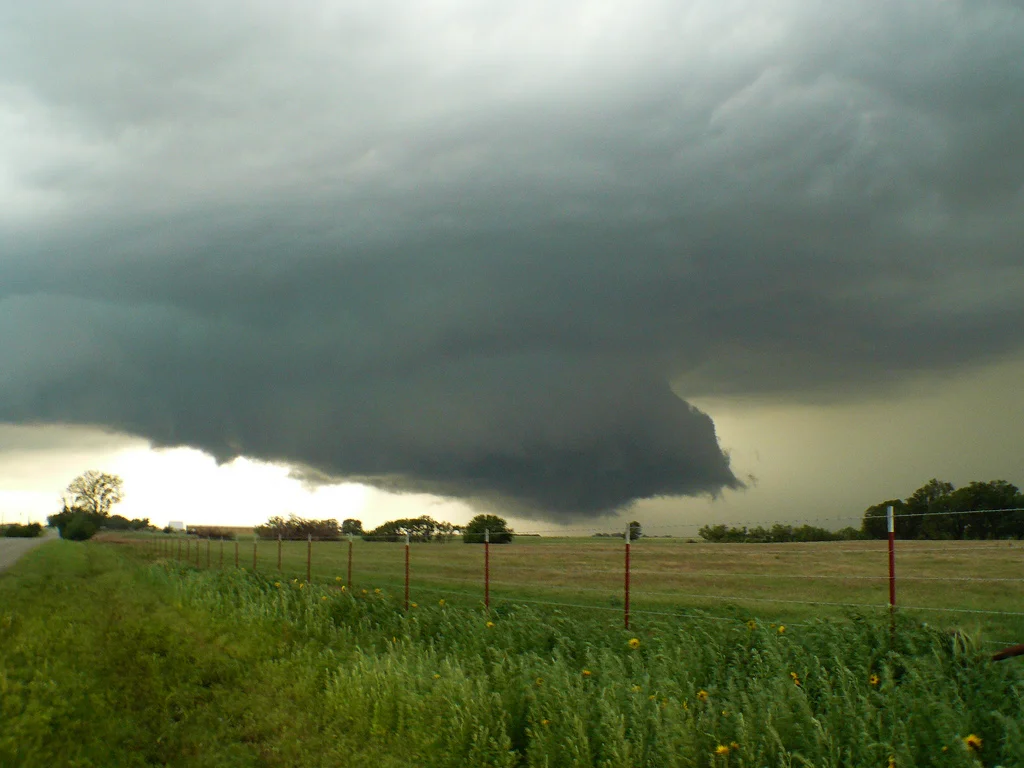
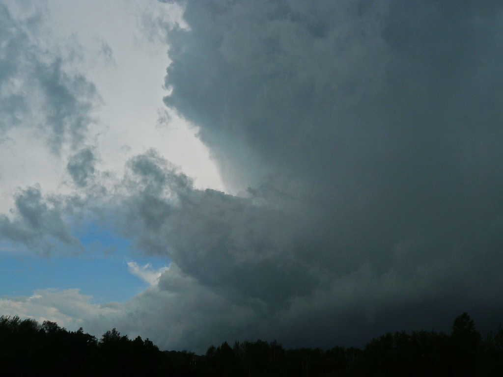
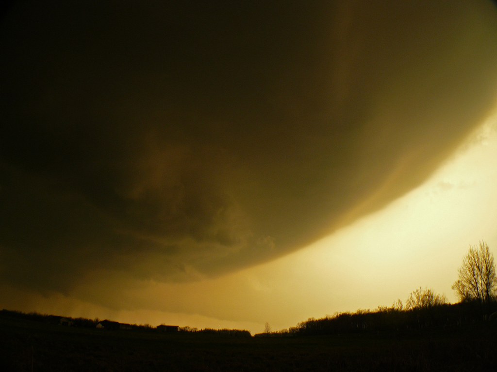
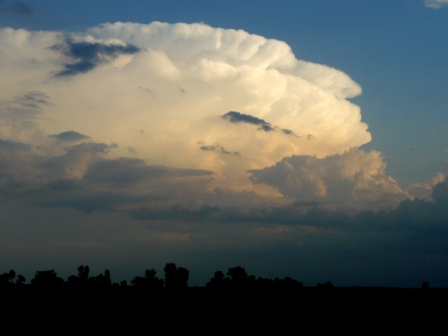
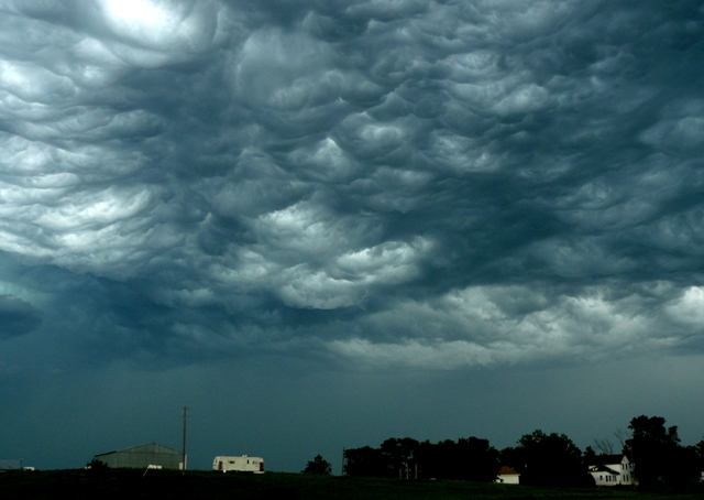
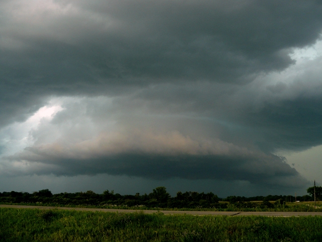
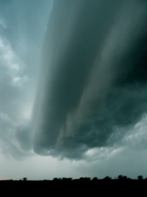
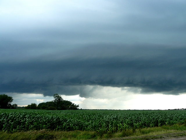
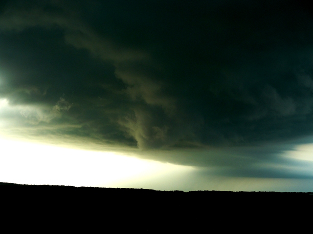
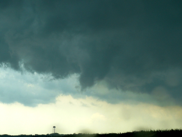
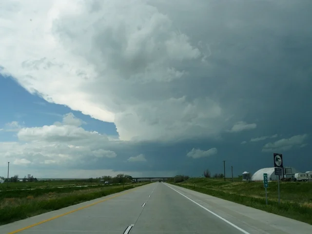
Strong updraft on storm as we approached from the west.  Notice the lowered base on the bottom left of the photo.

P1050542-2.jpg

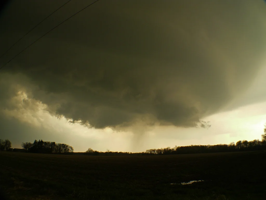
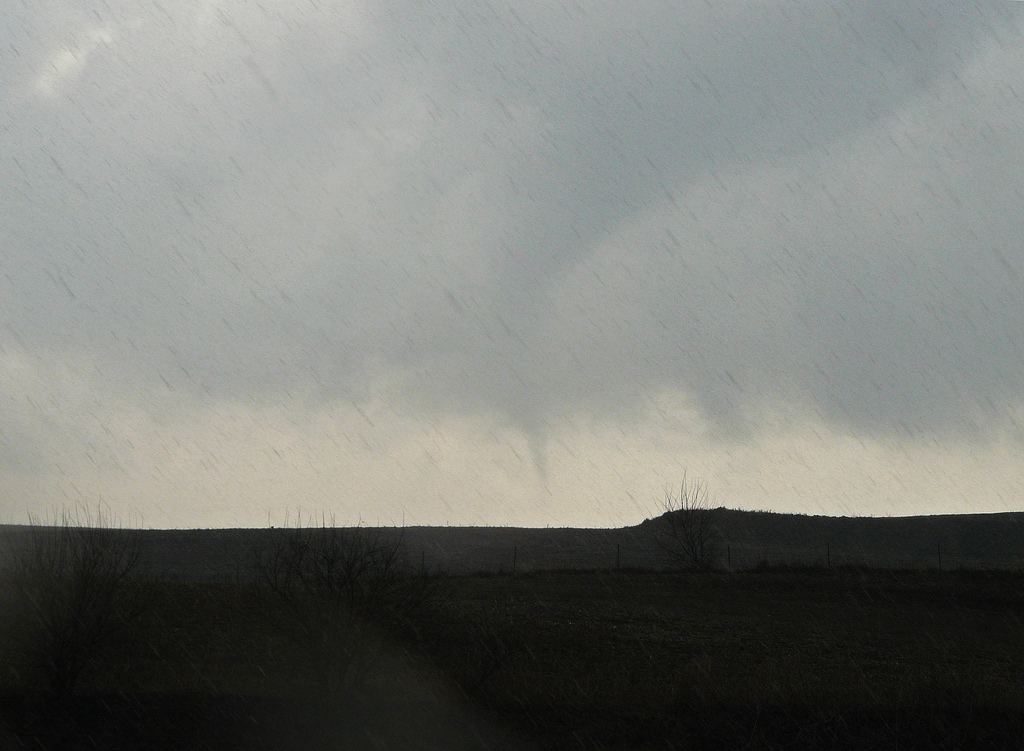
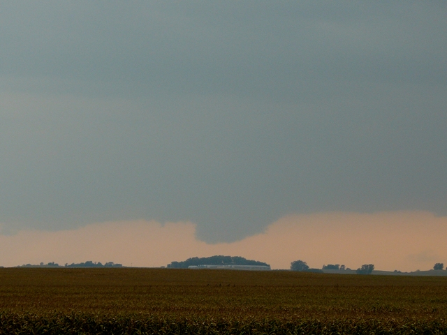
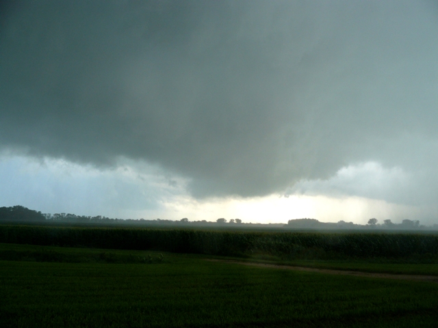
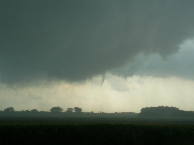
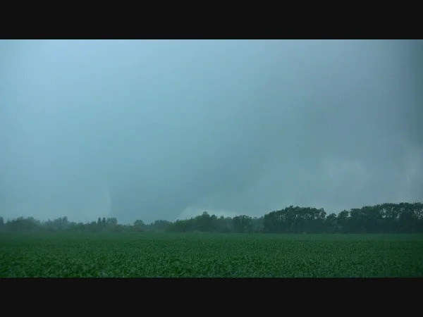
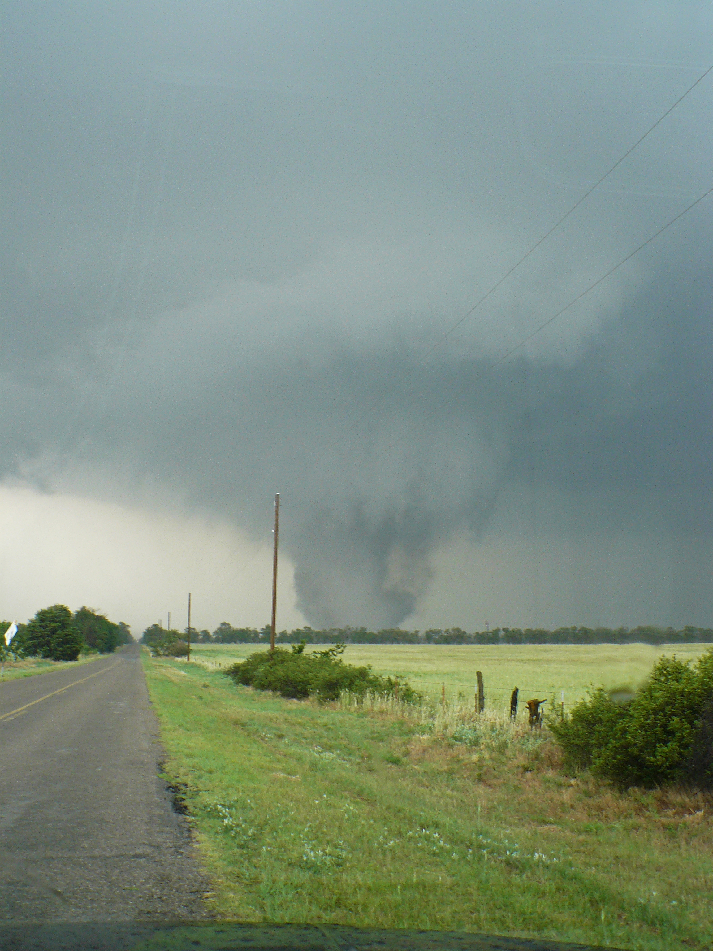
Tornado near Canton, OK.  Actually was stalled out and appeared to be coming back at us down the road at this point!

P1050543-2.jpg

Zoomed out view of the tornado as it crosses Hwy 58A.

P1050544-2.jpg

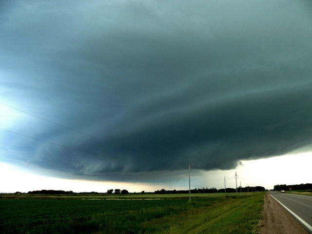
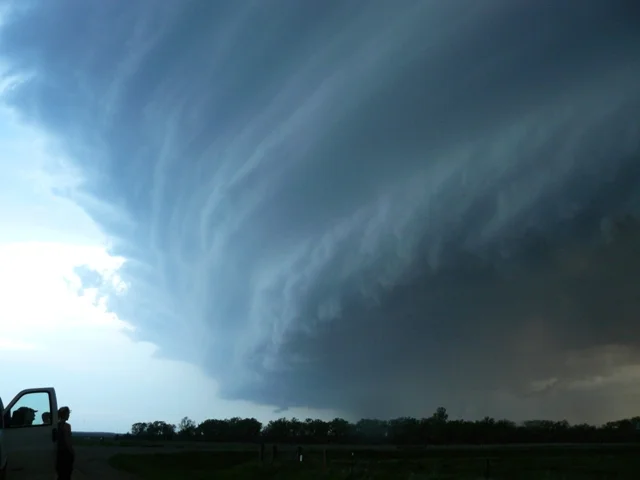
Another view of the tornado and violently rotating mesocyclone.

P1050546-2.jpg

Violent tornado starting to grow in size!

P1050552-2.jpg

Large cone tornado starting to become extremely violent.

P1050553-2.jpg

Incredible tornado moving to our north-northeast.

P1050556-2.jpg

Very large cone tornado at this point, and also notice the satellite funnel!

P1050570-2.jpg

Beautiful rope tornado near Fairview, OK.

P1050575-2.jpg

Another view of the tornado near Fairview, OK as we watched on Hwy 58, looking northwest.

P1050576-2.jpg

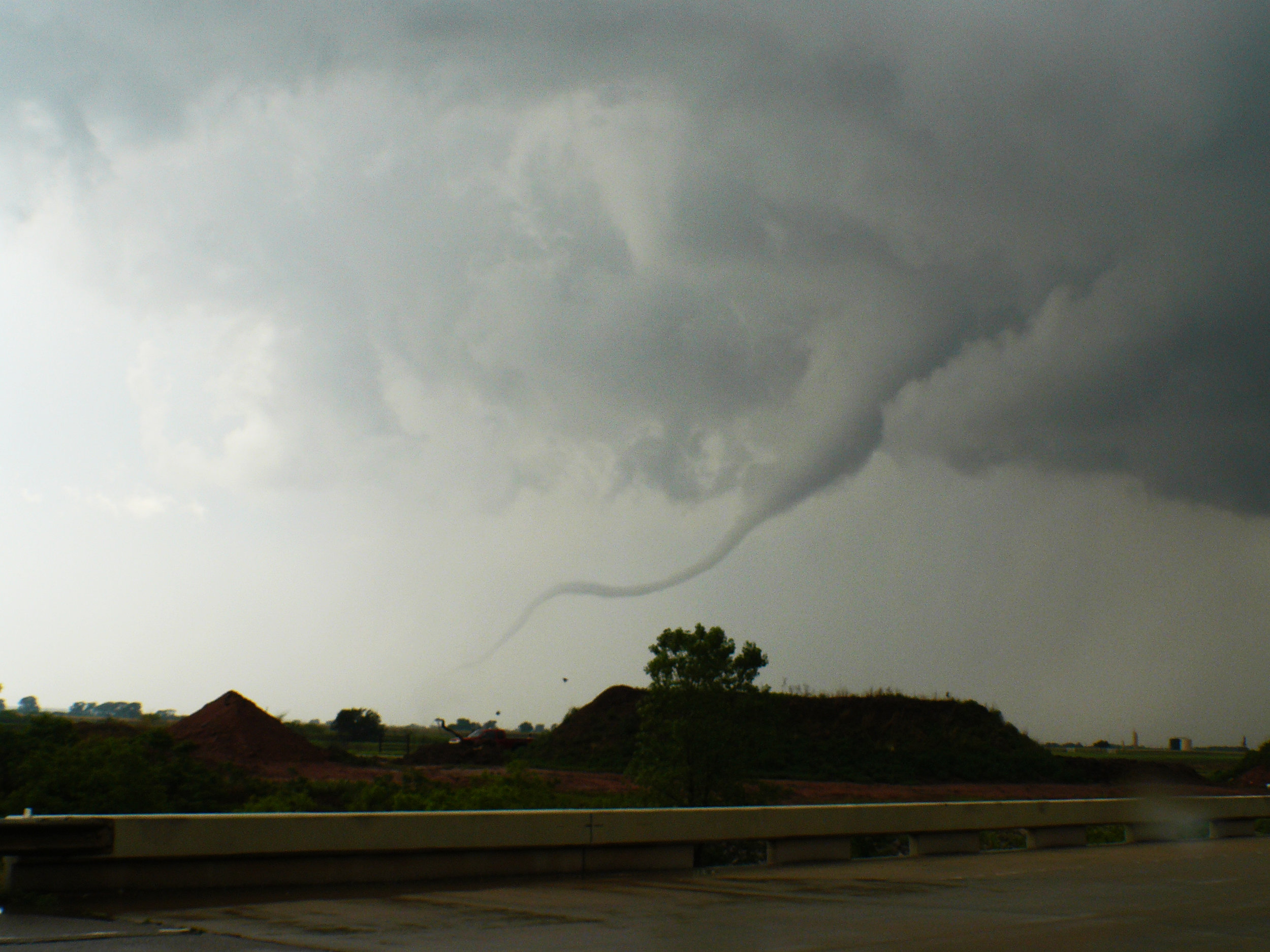
Tornado starting to weaken and rope out at this point.

More photos from this day can be found here:  http://www.flickr.com/photos/39991047@N02/sets/72157626821612302/

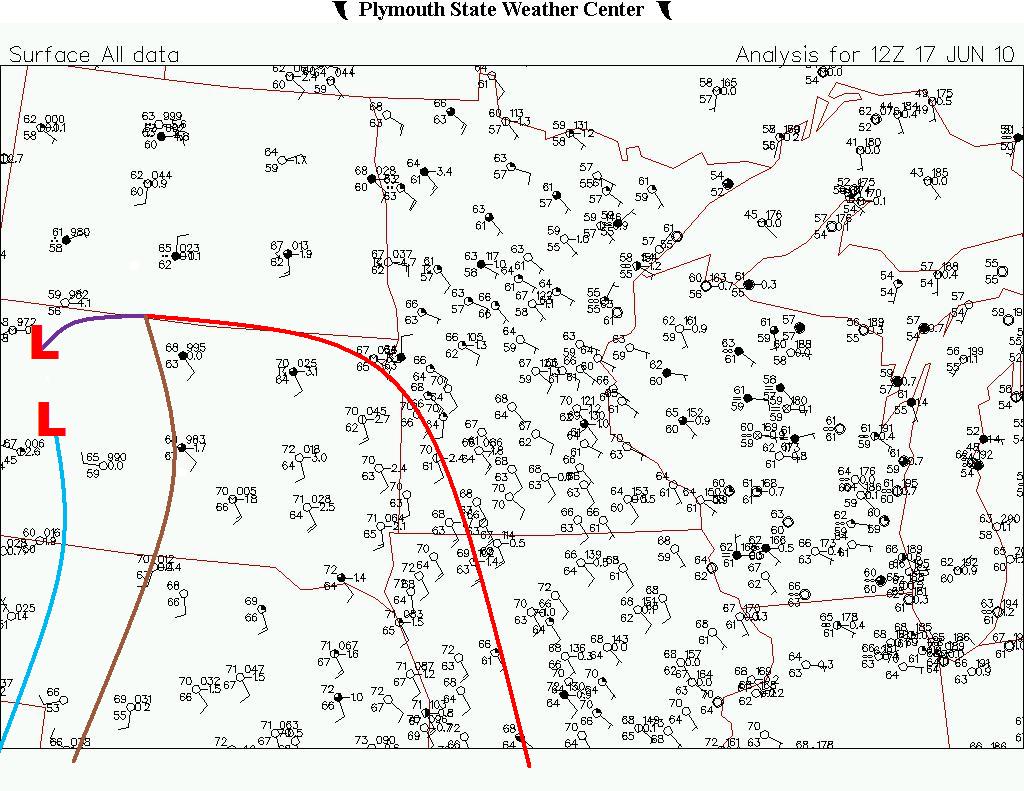
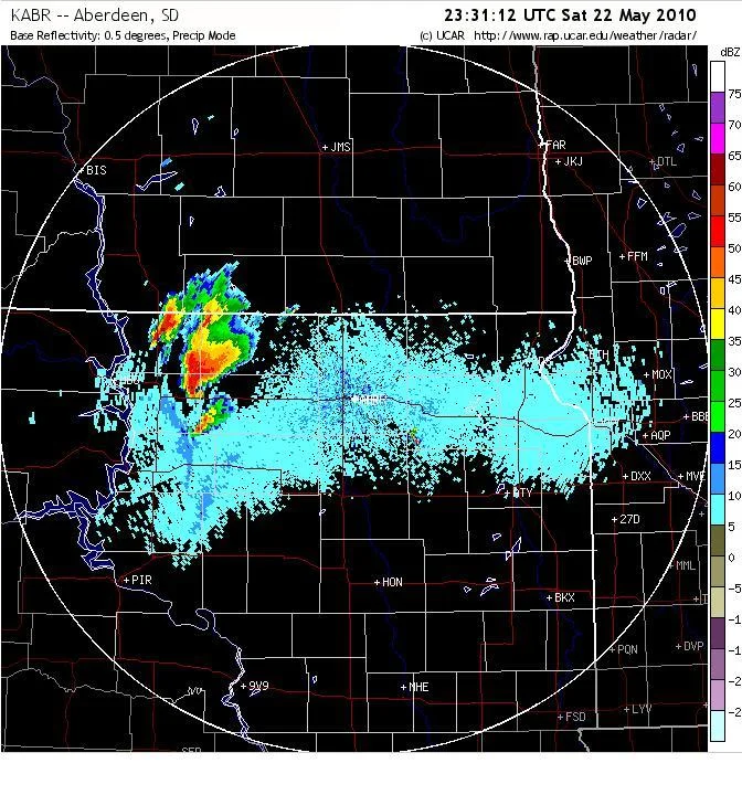
Radar image of storm at time of the tornado:

VNX_N0R_1105242020_800x600_KEND__173.jpg

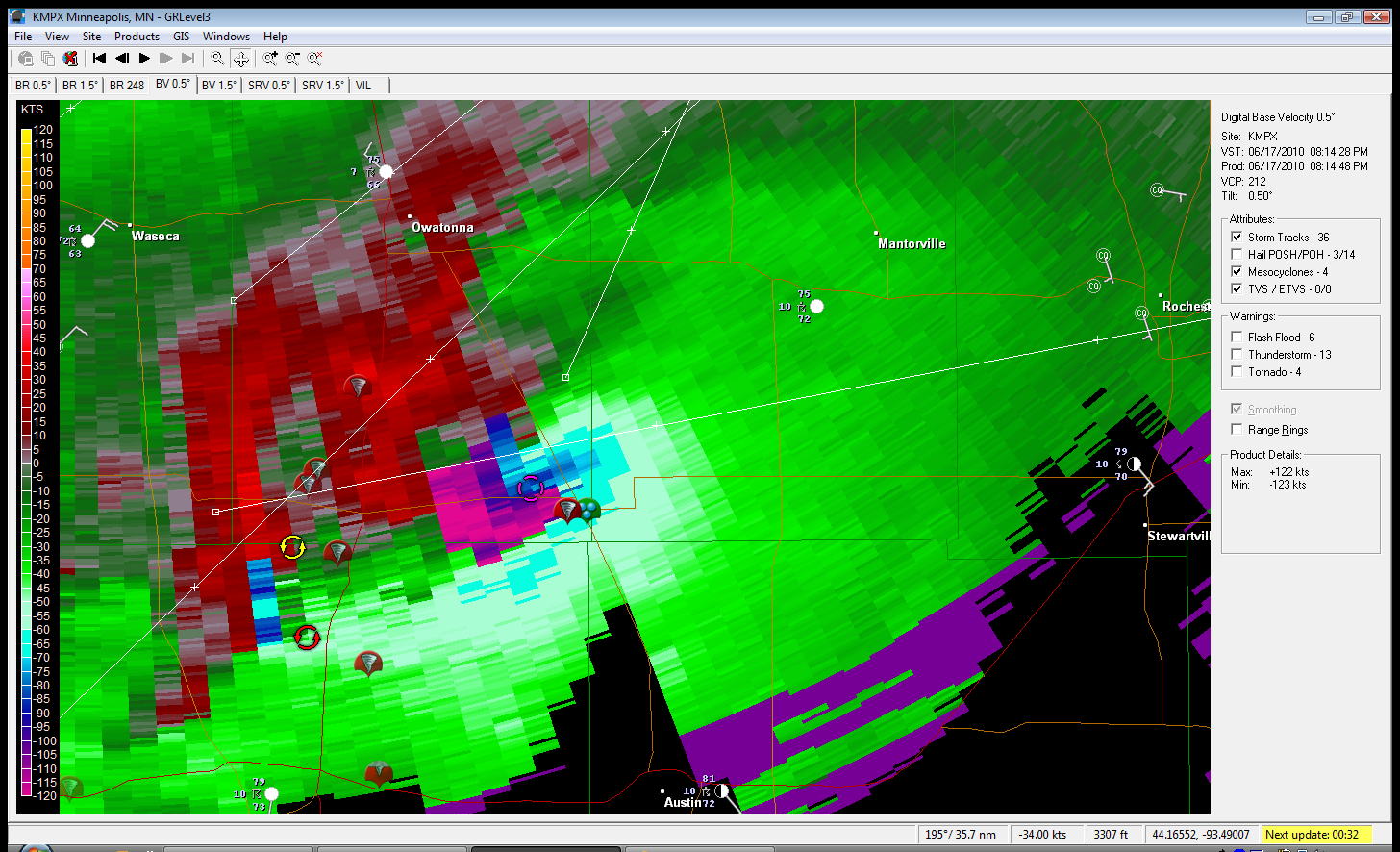
Base Radial Velocity at time of the tornado:

VNX_N0V_1105242020_800x600_KEND__173.jpg

The morning atmospheric sounding from Norman, OK showing the extremely volatile conditions, ripe for severe weather and tornadoes:
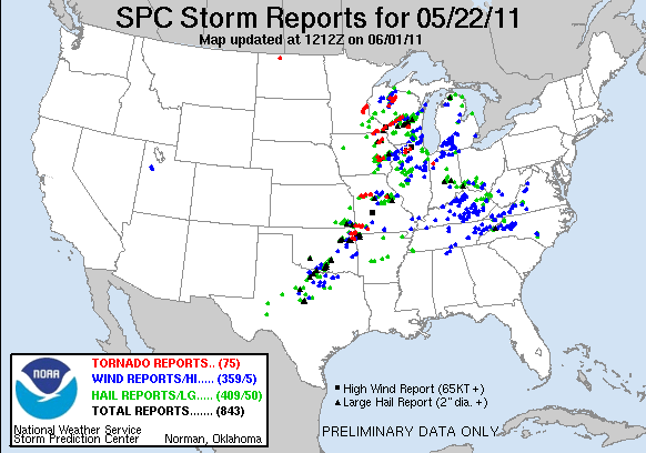
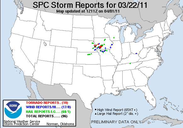
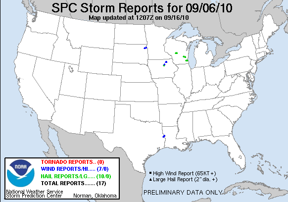
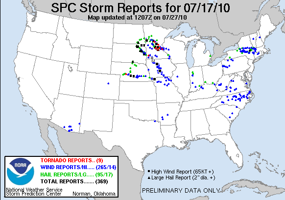
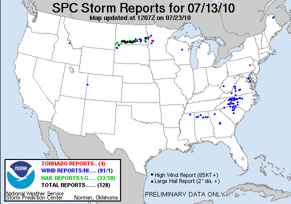
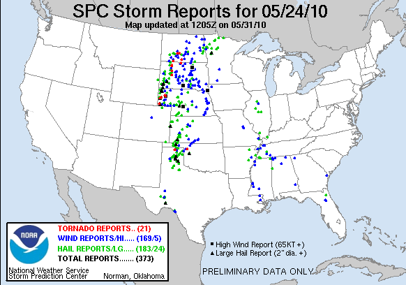
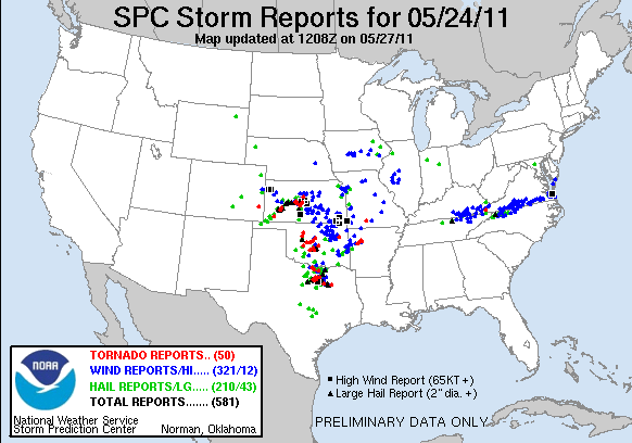
Norman Sounding.jpg

Storm Reports:

110524_rpts.gif

05-24-11 CHASE LOG: OKLAHOMA This log details our chase during a High Risk for severe weather with a whopping 45% hatched area for tornadoes! What will later be known as the May 24th Tornado Outbreak. The set-up featured a vigorous upper trough and shortwave ejecting out of the Rockies and becoming negatively tilted in the Southern Plains by the evening. At the surface, an area of low pressure was rapidly deepening through the day and sliding north from the Texas Panhandle into western Kansas, along with an associated warm front. A strong dryline extended south of the low and was forecast to advance through Oklahoma during the day, igniting storms in the rich moisture of upper 60’s and lower 70’s dewpoints with an extremely unstable airmass as MLCAPE values reached 4000-4500 J/KG. With strong south to southeast surface winds gusting 20-30 mph and 6 km winds strengthening to 90 kts by early evening, as well as strong turning with height, the wind shear was incredible as depicted already by the morning sounding out of Norman, OK (shown below).

There were going to be two separate areas to target and I had to make a decision to either go north into KS, ahead of the surface low and play the triple point, or even the warm front that had been enhanced by a morning outflow boundary, or play the dryline further south in the highly unstable and sheared airmass. The decision was made to stay in Enid, OK and wait for initiation along the dryline as it appeared to be sure bet for storms to produce tornadoes, some strong and possibly long-track. Note: The northern target also ended up producing many tornadoes across central and western KS.

Shortly before storms fired, we moved south on Hwy 81 to Kingfisher and then west on Hwy 33 as storms began to fire on the dryline. The first storm that started to look extremely strong with echo tops approaching 50k feet plus was near the Independence/Putnam, OK area. We circled around the storm, staying on Hwy 33 to Hwy 47 west and then north on Hwy 183 to cut the storm off going east on Hwy 51. The entire time we could see a lowering and then rotating wall cloud begin to form, the first signs that this storm was about to drop a tornado. Near the town of Canton, OK it produced a strong tornado that was later rated an EF3, producing winds of 136-165 mph. The damage path from this tornado spread 9 miles in length with a maximum width of ½ mile! We were able to get within ¼ - ½ mile of this tornado and witnessed first-hand the tornado inception and a substantial increase in size as the tornado moved to our north-northeast. We ended up following on Hwy 58, seeing another short-lived tornado in the vicinity of Longdale, OK. Continuing to follow the storm, we saw our third tornado of the day, a beautiful, long, rope tornado near Fairview, OK. Thereafter, the storm weakened as other storms began to interfere with it and disrupt the storms inflow. We decided to get ahead of the storms as numerous tornadic supercells were developing further south along the dryline and were quickly advancing east. Our path took us to Stillwater, OK where a tornado warned storm advanced upon the city. Apparently there were power flashes in the city at the time we saw the storm move through but we could not see if there was indeed a tornado as the storm was completely high precipitation and any tornado would have been rain-wrapped. MaryLynn and I stayed ahead of the storms till near Tulsa, OK before calling off the chase as it was becoming too dangerous to continue at that point. Not a bad day with 3 tornadoes on the first storm we came upon! Unfortunately, there were many other strong tornadoes across the state that did some major damage and sadly there were fatalities from this outbreak.

May 23rd Western Oklahoma Storm Chase - Homestead Tornado

 
5766555706_cabcf63993_b.jpg

One of the many funnels that were spotted shortly after initiation.  This was near Isabella, OK.

Actually have two funnels here at the same time, one in the background and the other in the foreground near Isabella, OK.

Funnel halfway to the ground near Homestead, OK.  Start of the tornado.

5766558694_dc2180687a_b.jpg

Beautiful tornado touching down near Homestead, OK.

5766561870_d3c2151a31_b.jpg

Tornado starting to rope out with debris cloud still present at ground level.

5766032627_07b4365581_b.jpg

Another storm blowing up to our southwest.

5766022935_69a90d40cd_b.jpg

Low precipitation (LP) storm completely tipped over along the dryline near Watonga, OK.

5766572706_5d44346ac3_b.jpg

Awesome looking LP storm with sharp updraft along the dryline near Watonga, OK.

5766029185_4da1ee081f_b.jpg

Low, rotating wall cloud near Kingfisher, OK.

5766584986_ef2dbf1e83_b.jpg

Another view of the wall cloud that almost produced a tornado near Kingfisher, OK.

5766043839_e122bb3281_b.jpg

Heard a few other chasers that also thought this was a funnel cloud near or right over Kingfisher as the action area became rain-wrapped.

More photos from this day can be found here:  http://www.flickr.com/photos/39991047@N02/sets/72157626821241478/

Storm Reports:

110523_rpts.gif

05-23-11 CHASE LOG:  OKLAHOMA This was a Moderate Risk for severe weather and a 10% risk for tornadoes through much of western and northern OK and far southeastern KS.  The set-up included a weak shortwave trough ejecting out of the Rockies into west TX during the morning and reaching our target area of northwest OK by the afternoon.  There was a warm front set up across northern OK that was enhanced by an outflow boundary from a morning MCS that moved through the area.  A dryline was forecast to progress into western OK during the afternoon with discrete supercells breaking out along this boundary by mid afternoon in an environment characterized by upper 60’s to lower 70’s dewpoints and 4000-5000 J/KG, moderate wind shear, and a weak cap.

We left Olathe, KS early in the morning and targeted the vicinity of northwest OK for the afternoon.  We stopped near Tonkawa, OK for lunch and also to re-evaluate as I did not want to underestimate the outflow boundary/warm front and storms developing along this boundary across north-central and northeast OK as they would surely have tornado potential.  The decision was made to head west near the dryline as storms developed between 2-3pm in far southwest and west-central OK.  Our course was to take Hwy 64/412 west towards Enid and then west of that area towards the Ringwood area where we watched storms develop on the dryline.  The storm that caught our attention was further southwest and was clearly the dominant storm on the dryline at the time, so we progressed south on Hwy 8.  As we were looking west, just to the north of Okeene near 3:36pm, the storm produced a tornado near the Longdale/Homestead areas that was rather short lived but absolutely beautiful with how high the LCL’s were.  This was a rope tornado that did not produce any damage from what we could tell.  We followed this storm to the east, and even dropped south on another storm, before moving back north to near Kingfisher where we witnessed a rotation wall cloud just to the north of town.  At this point, it was very close to producing a tornado, but could not completely get its act together and died out before producing.  Shortly after, the storm turned into a mess as we followed east and became very high precipitation (HP).  We ended up heading back to Enid for the night to prepare for the next day’s chase.

May 22nd East Central Minnesota Storm Chase - Forest Lake Tornado

 
5765823529_aa648b39aa_b.jpg

The storm approaching the Forest Lake, MN area with sharp updraft on the south side.

Looking to the west off Hwy 97 just to the west of Cty Rd 15 as the tornado is about to come down.

5766335246_bf745ac695_b.jpg

Tornado touching down just to the south of Hwy 97 to the southeast of Forest Lake, MN.

5765804089_cbc8734d0b_b.jpg

Tornado about to cross Hwy 97 to the east-southeast of Forest Lake, MN.

5766356492_463601923a_b.jpg

Another shot of the tornado about to cross the road with some debris in the air.

5765813161_47343ded71_b.jpg

Tornado crossing the road and starting to throw tree limbs, branches and other foliage into the air.

5766367020_705793ca27_b.jpg

Tornado starting to lift to the north of Hwy 97 a few miles east of Forest Lake, MN.

More photos from this day can be found here:  http://www.flickr.com/photos/39991047@N02/sets/72157626820607856/

Storm Reports:

110522_rpts.gif

05-22-11 CHASE LOG:  MINNESOTA

This was not your typical chase day as I flew in from a work trip and landed at the MSP airport shortly after noon.  MaryLynn and I had planned on leaving for Kansas City to spend the night and chase on Monday, May 23rd, but knowing that there was a Slight Risk for severe weather and a 10% hatched area for tornadoes across southeast MN, just clipping the Twin Cities, I kept an eye on the weather before we left for our trip.  The set-up included a potent upper low across southwest MN that tracked northeast through the day.  A warm and humid airmass overspread the region ahead of a cold front slicing through the area during the early to mid afternoon.  Thunderstorms initiated along this front during the early afternoon and a tornado warning was soon issued for the Minneapolis area.  This storm did produce a damaging tornado in and around the northeast side of the city of Minneapolis and sadly 1 fatality.  We headed up I-35E as this storm continued its track to the north of the metro area.  A new storm developed in the vicinity of Roseville/Arden Hills, while we paralleled the storm to the east and northeast.  This storm soon became tornado warned as Doppler radar was showing signs of rotation.

As the storm approached the Forest Lake, MN area and was still tornado warned, we wanted to get out ahead and take Hwy 97 east as the couplet headed northeast towards our location.  Around a mile to the west of the Hwy 97 and Cty Rd 15 intersection, the storm produced a tornado that touched down for roughly 2 minutes or so.  The tornado did not appear to produce any significant damage, but we could visibly see large tree limbs and branches being thrown into the air.  The tornado was later rated an EF-0, producing winds of 65-85 mph.  Quite the surprising tornado considering that I was not even planning on chasing on this day!

May 10th Central Minnesota Storm Chase - Strong Supercells With Hail

 
5711200925_fc3fe9e8a2_b.jpg

Inflow tail on the left and twisting updraft on storm to the west of Holdingford, MN.

5711762068_4d7d14b3a5_b.jpg

Storm #1 on the right near Holdingford, MN and another intense supercell developing on the left near St. Cloud, MN.

5711198723_6725250ba6_b.jpg

Intense supercell forming an anvil to the southwest of St. Cloud, MN.

5711755856_b6e0e26fd0_b.jpg

Large mesocyclone and clear slot on storm east of Foley, MN.

Mesocyclone really starting to wrap up at this point.  Notice the striations.

5711754622_ba27e75160_b.jpg

Another shot of the meso and turbulence in the bowl.

5711203247_7ef3b46e09_b.jpg

Starting to get underneath the mesocylcone and edge of the action area.

5711764438_b9e6152bcd_b.jpg

Nice color as the sun was setting behind the cell and the base was starting to move overhead.

5711759242_2191c9f08b_b.jpg

Larger view of the base.  Tough to see, but notice the inflow tail into the storm that is in the distance and slight lowering on the left side of the picture.

5711204775_1625a187ae_o.jpg

Possible funnel on now tornado warned storm north of Princeton, MN after dark.

More photos from this day can be found here: http://www.flickr.com/photos/39991047@N02/sets/72157626701212780/

Radar near most intense time of supercell (circled in red):

5711764824_151404e3d8_o.png

MPX 00Z May 11th Observed Sounding:

5711204875_7c1a0f1713_o.gif

Storm Reports:

110510_rpts.gif

05-10-11 STORM CHASE:  MINNESOTA   Going into the day, the main concerns were the capping and if a shortwave would arrive in time for thunderstorms to be able to break this cap, as well as weak mid and upper level winds (even rather weak inflow winds to some degree).  An upper trough and low was well to the west of the area, centered across the western Dakotas while a large ridge was building into the Midwest and Great Lakes region.  Instability was not an issue with MLCAPE values in the 3000-5000 j/kg range nosing into central MN and SBCAPE values of near 6000 j/kg in spots, as noted by the 00Z MPX observed sounding.  Extreme instability was present with dewpoints well into the 60’s and lower 70’s along and south of a warm front that was draped along the I-94 corridor and an impressive dryline/trough that was advancing through western MN.

  Our course of action was to initially target the area between Little Falls and Staples, MN.  We left around midday and went up I-94 to St. Cloud where we waited for things to evolve.  Shortly before 5pm, a few showers and storms began to develop in the vicinity of Alexandria.  As we went up I-94 towards the area, storms really were having a difficult time getting going and thinking was that they were elevated above the cap and could not become surface based for the first 2-3 hours after initiation.  We stopped near Sauk Centre and re-evaluated, whether to continue north to a cell nearing Long Prairie, or head south towards another cell.  We decided to head north towards the cell near Long Prairie, but this cell was not looking as good so we bailed towards the cell moving up from the south.  Upon reaching Holdingford, the cell that we were on was not making much progress, although it did have a nice inflow tail and twisting, albeit skinny, updraft.  Yet another cell was developing to our southeast near St Cloud which was starting to get its act together a little more, right around the time a tornado watch was issued for the area.  We chose to again bail on the cell we were on and travel down Highway 10 towards the cell moving to the Sauk Rapids area.  We got on the cell shortly after it had produced tennis ball size hail in this area, but ended up following the storm east as it slowly moved towards Foley.  The good thing about this day is that, with the weaker steering flow aloft, storms were easy to keep up with.  Between Foley and Princeton, MN is when the storm looked the best.  We stayed on Highway 4 and followed near the base as a large mesocyclone developed with off and on periods of rising motion.  This cell was clearly attempting to make at least a wall cloud and we even had some rapid condensation taking place very close to us at one point, which indicated a possible funnel developing (as seen in the video).  It became too dark to see much of anything between the lightning flashes near Princeton but this was just as the storm became tornado warned.  We followed near the hook signature on radar for a little while longer and noticed a lowering between the flashes off to the east of the intersection of Highway 169 and Highway 4.

  The extreme instability, but with weak vertical wind shear, likely led to supercells that contained a lot of large hail (due to the potent updrafts); with only 1 tornado reported near St. Michael, MN.  This tornado appeared to be an effect from the storm staying rooted on the boundary at the exact right time during the storms maturation and right at the dryline and warm front intersection.

March 22nd Southwest Iowa Storm Chase - Defiance Tornado

 
5553545859_b72d384073_o.jpg

First storm of the day going up as we are looking to the southwest of Nebraska City, NE.

5554130148_3e6817db49_o.jpg

Mammatus forming as the anvil moves overhead.

5554120504_09e690ffcc_b.jpg

A terrific omen as we were traveling north on Highway 57 to intercept a tornado warned storm.

5553544801_04f67f3a7d_b.jpg

Tornado only a few miles to the northeast of Defiance, IA!

5554130424_8f0c35964c_b.jpg

Another view of the tornado as the hail was really starting to fall.

5554131000_a7bd437837_b.jpg

Tornado snaking around as it is starting to rope out.

5554131492_9c3748e8cc_b.jpg

View of the entire portion of the tornado roping out.  Notice the tornado condensation funnel detached in spots but still discernible from top right to bottom left.

5554132498_85d5f03b63_b.jpg

Top portion of the tornado coming out of the back of the storm.  Starting to become detached from the lower portion.

5554131714_b408fc0bb7_o.jpg

Video grab of the tornado from cloud to near ground as it is roping out.

5553538031_c4a2486afa_b.jpg

Ragged wall cloud on the storm north of the warm front near Manila, IA.

5553543505_4507e48450_b.jpg

Extremely low clouds to the north of the warm front and wind turbines hidden from view in spots.

5554134798_4cd7f089d2_o.jpg

Radar image near time of the tornado.  The white circle outlines the storm.

Storm Reports:

Map of 110322_rpts's severe weather reports

03-22-11 CHASE LOG: IOWA This log describes the details of my first March tornado!  Our chase team included Beau, Donya, and Ephram Gjerdingen, Mike Nardozzi and me.  We began the day driving south on I-35 at 8am, heading for a target area of west-central IA.  With a strong, spring system already impacting the region, we were forced to drive through rather treacherous conditions on our way down as accumulation of hail and sleet occurred during the morning hours from Faribault to Owatonna, MN.  Several cars and a semi were seen in the ditch as a result.  Upon clearing the wintry weather, our course took us to I-90 west and then south on Highway 60/75 to Sioux City, IA.  Thereafter, our plan was to take I-29 south to near Council Bluffs, IA to re-evaluate.

The set-up was as follows:  A deepening area of low pressure was parked over northeast NE through the day as a warm front stalled out to the southeast and then into IA along the I-80 corridor.  To the north of this front, low clouds, drizzle, and gusty easterly winds limited temperatures to the 40’s and 50’s, while instability built south of the front as temperatures soared into the 70’s and even low 80’s, with dewpoints rising into the mid and upper 50’s.  There were even a few low 60 dewpoints that I noticed were pooling across southwest IA by mid afternoon, terrific for this time of year.  Further west, a strong cold front and pre-frontal dryline were surging east through NE as an upper level vort max ejected out of southwest CO and was noticeable on water vapor heading towards the target area.  An upper level trough was forecast to go strongly negative tilt through the day, which helped to significantly increase the synoptic lift.  This could be seen by the moistening of the mid levels as seen on water vapor imagery.  With the strong heating, SB Cape values of 500-1000 J/KG were nosing up into southeast NE and southwest IA, more than enough instability with how much wind shear was forecast in the warm sector and along the stationary front.

As we approached Council Bluffs, the Storm Prediction Center (SPC) issued a Mesoscale Discussion (MD) at 1:19pm.  A storm soon began to develop near Concordia, Kansas at 1:30pm.  We decided to head further south and position ourselves near Nebraska City, NE to watch this storm come at us.  Storm motion was at 35-45 mph with a few storms even faster, so the trick was to attempt to stay ahead of the storms as much as possible.  The storm approached us and entered southwest IA with a noticeable lowering as it passed over the river at 4:15pm, as other storms filled in further north along the dryline/cold front.  We followed east on Hwy 2 and the zigzagged to go north on Hwy 59.  The storm was starting to become more HP and was difficult to keep up with, so we were forced to get behind it and travel north to I-80.  At this point, the decision was made to not attempt to stay ahead of that storm, which later produced a tornado near Creston, but to continue heading north and intercept a supercell that was already tornado warned and moving northeast of Omaha, NE.  This was also the time that SPC issued another MD for the area outlying the greatest tornado potential.  The storm appeared to be right on the triple point at this time and interacting with the stationary front.  We intercepted the storm near Defiance, IA and witnessed an incredible anti-cyclonic tornado out the back of the storm and roping out all the way to the ground as we were on 2400th St looking southeast.  This was an incredible scene and the tornado appeared to linger along the ground in an open field, even after the entire middle portion of the tornado appeared to die off and become disconnected.  Thereafter, we followed the storm northeast of the area but it was clear that the cell had now moved well north of the boundary into the cooler, more stable air, and was not going to produce further tornadoes.

2010 Storm Chasing Highlights Video


  2010 goes down as the most insane and successful storm chasing year that I have had to date.  This video details only a small fraction of the tornado, hail, wind, and extreme weather highlights from some of the more prolific severe weather days in 2010, including April 29th, May 18th, May 19th, May 22nd, May 23rd, May 25th, May 26th, June 1st, June 17th, and July 14th.  I began the year by seeing the Washington, KS tornado on April 29th, but the real show came later in May when I was a guide for Silver Lining Tours, a storm chasing tour company.  During the 10 days of that trip, we had seen 18 tornadoes...definitely the most amazing stretch of tornado days in my life.  The most incredible tornado of the year occurred on May 22nd with the Bowdle Wedge tornado, while the chase day of the year occurred on June 17th with the Minnesota Tornado Outbreak.  What an incredible year it was and I am very fortunate to have been able to experience it all.  Now on to the 2011 Chase Season!

September 6th, 2010 Storm Chase - Severe Thunderstorm

09-06-10 CHASE LOG:  IA   After flying in from KPIT for work, I had the rest of the day off and thought it would be decent enough set-up to try a relatively local chase.  MaryLynn and I left Burnsville around 2:30pm and went south on I-35, targeting somewhere in the Mason City, IA area where I thought the best combination of low/deep layer shear, instability, and moisture would be in place.  We ended up reevaluating things at the Albert Lea truck stop and storms started to fire on the cold front to the southwest of the area as a small area of clearing allowed things to destabilize.  One, messy storm was near Emmetsburg, IA so we waited around until another, southern storm fired near Fort Dodge and looked a little better, having access to the better environment as well.  We intercepted the storm a few miles west of Dows and it really did look decent for a short while with a nice lowering that was in the right spot underneath the updraft (see pics below).  After this storm struggled to get its act together, we progressed north to another storm that was starting to look better and saw a messy lowering near Northwood, IA.  Not really good enough to post any pictures though. 

  Nice little chase day, overall, but thought it would turn out at least a little better.  All of the cloud cover and elevated showers really held down the instability and the cold front was moving very fast so I think those were some of the main issues.  Plus the tight, compact vorticity center was well to the north across central MN.  Certainly this system did not lack wind shear!

P1050202-3
P1050202-3

Storm when we first got on it near Dows, IA with noticeable lowering underneath the vault.

P1050207-3
P1050207-3

Lowering becoming more well defined and closer to the ground a few miles west of Dows, IA.

P1050208-3
P1050208-3

Zoomed out view of the lowering underneath the storm.

P1050212-3
P1050212-3

Beautiful view to our south of another storm near Ames, IA.

More photos from this day can be found here:  http://www.flickr.com/photos/39991047@N02/sets/72157625199922745/

Storm Reports:

100906_rpts
100906_rpts

July 17th, 2010 Minnesota Storm Chase - Supercell Thunderstorm


07-17-10 CHASE LOG:  MN   A moderate risk for severe weather, issued by the Storm Prediction Center, was in place this day across much of MN.  A surface low was forecast to move into northeast SD and extreme west-central MN by late in the day while a warm front was draped to the north of I-94 across north-central MN and a cold front into eastern SD.  Peggy Willenberg, MaryLynn, and I left the Twin Cities near 1pm and progressed northwest on I-94, targeting an area just to the west of Elbow Lake, MN near the MN/ND/SD border area.  Our initial thoughts were to position ourselves just ahead of the triple point that was expected to be near this area by late afternoon, shortly after initiation.  However, Mother Nature threw a wrench into things and a very nice supercell developed on the warm front near Sauk Centre, MN and we were in perfect position to intercept the storm near Melrose around 3pm.  This storm was already in a highly sheared and unstable environment and soon got its act together, producing a couple of ragged, rotating wall clouds near Melrose and near Oak Township.  The storm was already producing a large mesocyclone to the northeast of the wall clouds and this meso was starting to arc and gust out at this point, with a shelf-like feature on the leading edge.

  After getting cored by this storm and getting hit by nickel sized hail near Oak Township, there were other storms that fired ahead of the stronger supercell.  At this point, our main storm had weakened with no wall cloud or lowering visible.  Based on what was occurring, we thought the storm was traveling into a “slightly” less favorable environment than what was further west-northwest of our position.  The environment that this storm was heading into was still favorable overall to sustain itself and produce tornadoes, but was slightly less favorable as the storm progressed southeast towards the Twin Cities.  This storm did end up having beautiful structure upon moving towards the northwest Twin Cities metro and a huge, rotating, gusted out meso.  There were a couple of tornado reports from this cell, but I am doubting any tornadoes actually occurred as the reports were suspect, no pictures or video of the “tornadoes” were taken, and the damage that occurred was more coincident with straight line wind damage and hail.

  After bailing on the storm we traveled up I-94 and then took Hwy 27 west out of Alexandria towards Wheaton.  Intense thunderstorms had already developed north of the warm front, near the triple point and along the cold front, with a few of these storms well to our north being tornado and severe warned.  New storms began to fire ahead of the initial storms on the triple point and we waited to see what these would do.  SB CAPE values at this time were in the 1500-2500 J/kg range with a nose of 3000 J/kg pocking up into southwest MN, while Effective Helicity values were actually in the 300-600 m2/s2 range across this area!  This would normally be very supportive of strongly rotating supercells, but it became apparent that the upper trough had arrived at this point, as there were numerous updrafts occurring and the storms were starting to congeal into a big mess with the cloud shield spreading downstream and seeding any new storms that were trying to develop ahead of the forming cluster in SD.  We picked a couple of the stronger updrafts and tried to stay ahead, while storms began to go linear by 7pm.  There was a nice shelf cloud that we stayed ahead of from Willmar to Delano, where we finally let it overtake us with heavy rain, small hail, and estimated winds up to 45 mph.  The storm did bow out through the far northern Twin Cities metro and produce some wind damage through this area after we had ended the chase for the evening.

P1040941-3
P1040941-3

Turbulent sky approaching the supercell near Albany, MN.

P1040943-3
P1040943-3

Looking at the approaching beast of a storm near Albany, MN.

P1040945-3
P1040945-3

Large mesocyclone underneath the supercell near Melrose, MN.

P1040946-3
P1040946-3

The edge of the mesocyclone and storm base near Melrose, MN.

P1040960-3
P1040960-3

Rotating wall cloud with rising scud into it near I-94 and exit 131.

P1040964-3
P1040964-3

A short time later as the wall cloud was starting to become more blocky and still rotating with rising motion.

P1040967-3
P1040967-3

Very fast rising motion and condensation into the storm base near Meire Grove, MN.

P1040978-3
P1040978-3

Another wall cloud behind the rain curtain near Grove Township, MN.

P1040981-3
P1040981-3

Mammatus underneath the anvil near New Munich, MN.

P1050001-3
P1050001-3

Leading edge of shelf cloud near Litchfield, MN.

More photos from this day can be found here:  http://www.flickr.com/photos/39991047@N02/sets/72157624617679940

Storm Reports:

100717_rpts
100717_rpts

July 13th, 2010 North Dakota and Minnesota Storm Chase - Slow Moving, Photogenic Supercell


07-13-10 CHASE LOG:  ND/MN   I did not expect to be storm chasing this day as I had things going on.  However, I somehow managed to get everything accomplished by 1 PM and left Burnsville with MaryLynn, targeting extreme northeast SD.  The setup was an upper trough approaching this area with an area of low pressure across north-central SD and a warm front draped across northeast SD into west-central MN.  This was a modest instability and sheared environment with SB CAPE values of 1000-2000 J/KG nosing northward into the eastern Dakotas and lesser instability and wind shear into MN, while a nose of higher instability was noted further west across central SD.  An intense complex of thunderstorms developed north of the warm front, first near Bismarck as we left the Twin Cities and continued to evolve, become surface based, and maintain intensity with supercell characteristics as the storms traveled into southeast ND.  We traveled to Ortonville, MN and the thinking was that new storms would fire to the south on the warm front in southeast SD, and we would be in perfect position.  However, it became clear that this area was going to remain capped as the cumulus became flat with little to no vertical development.  Our only chance at anything was to go north on I-29 and make an attempt to intercept the supercells that were slowly moving into southeast ND.  The southern end of the thunderstorm clusters had been tornado warned all afternoon and remained warned as we approached from the south on Hwy 18.  The storm had yet to produce a tornado and continued to cycle wall clouds as we followed on east on Cty Rd 2, across I-29 and then east on Cty Hwy 30 in MN.  Near the ND/MN border near the town of Christine, the storm produced a low, rotating wall cloud and a large funnel for around a minute.  This was the storm’s only shot of producing from when we were on the storm.  Near the same time, another storm to the north produced a tornado northeast of Fargo, ND.  Overall this was a good chase as the storm we were on had beautiful structure and, at times, a terrific “mothership” appearance.  It was nice to be able to follow such a slow moving, photogenic supercell through open terrain without many other chasers around.  After the cell crossed into MN, it was getting dark, so we bailed on the storm shortly after 9 PM near I-94.  This storm later produced an EF-0 tornado near Dent, MN after dark.

P1040803-3
P1040803-3

Vault region of supercell near Leonard, ND.

P1040817-3
P1040817-3

Lowered base under rotating mesocyclone region of supercell near Leonard, ND.

P1040830-3
P1040830-3

Inflow region and structure of supercell near Walcott, ND.

P1040837-3
P1040837-3

Another shot of the storm structure and Liberty Bell appearance near Walcott, ND.

P1040850-3
P1040850-3

Funnel cloud forming on the supercell near Christine, ND.

P1040863-3
P1040863-3

Another shot of the funnel forming on the supercell near Christine, ND.

P1040867-3
P1040867-3

Funnel cloud on the storm near the ND/MN border.

P1040876-3
P1040876-3

Awesome view of the supercell and the storm base east of Wolverton, MN.

P1040880-3
P1040880-3

Base underneath storm and hail core in the background near I-94 south of Barnesville, MN.

More photos from this day can be found here:  http://www.flickr.com/photos/39991047@N02/sets/72157624396366691/

 Storm Reports:

Map of 100713_rpts's severe weather reports

July 14th Southeast Minnesota Storm Chase - The Northfield Tornadoes


07-14-10 CHASE LOG:  MN   This was a day that many, as well as myself, were hyping for tornado potential and it did not disappoint.  MaryLynn and I, as well as our friend Sheena McLain, left Burnsville around noon and headed down I-35 to Faribault, MN to wait for initiation, which was expected during the early afternoon hours.  My thinking was to get south of where I thought storms would initiate and approach from the south where we could get a better view and not have to core punch if storms fired quickly.  Convection had been firing all morning over the Twin Cities Metro and these storms appeared to lay out an outflow boundary just south of the metro area.  Storms fired before 2 PM to the west of I-35 and one storm in particular took off on the boundary, with an echo top that quickly grew to over 55,000 feet.  Our plan was to intercept this storm by taking Hwy 19 west of I-35.  Unexpectedly, we ran into some road construction near Lonsdale and the storm almost managed to get away from us before we made it through and around the detour and east on Cty Rd 86. 

  As we traveled on 86, there was a lowering directly ahead that was trying to organize into a wall cloud.  This feature did not manage to get its act together but a different wall cloud soon formed to the south of 86, a few miles northwest of Northfield.  The wall cloud quickly started to rotate and form a funnel and at this time I called the report into the NWS as there was not a tornado warning on this storm yet.  Soon the tornado warning came out and almost instantly the first funnel descended to near the ground around 2-3 miles north of Northfield.  It was short lived and we questioned at the time whether it did touch down, but soon got confirmation of several spotter and chaser reports that it indeed was a tornado.  The wall cloud quickly recycled and developed another, and larger, funnel 3-4 miles northeast of Northfield that became an elephant trunk and was easily over ¾ of the way to the ground.  This also was a confirmed tornado that damaged some buildings and blew over a semi on Hwy 47.  We stopped at the intersection of 86 and Hwy 56 as the tornado lifted but with a continued rapidly rotating funnel to near our location before the feature dissipated. 

  The tornadic storm soon became cut-off from good inflow air by a storm to its south and east and we decided to bail on Hwy 52 to get south of the line of developing supercells.  We core punched a few storms with extremely heavy rain and got south of the developing line.  Nothing was really looking all that great at this point but there was a new storm developing near Stewartville, MN that was directly south of our location and would be an easy intercept if we went south on Hwy 52 to I-90 east.  We eventually did intercept this storm that was moving at 50+ mph near Lewiston and this is where we saw another wall cloud and a short-lived cone funnel.  We followed the storm to Winona and watched it race off into WI.  Thereafter, another storm fired to our west so we traveled back west on I-90 to intercept the storm near St Charles.  This storm had some interesting features but nothing that looked like it would produce so we decided to start heading home for the night.

  As we had dinner in Rochester, new storms fired on the cold front and became severe as we left Rochester to the north on Hwy 52.  Upon reaching Oronoco, we could see a very low, ground dragging wall cloud that had formed on a cell near Zumbro Falls!  This really was a surprise as I was expecting everything to be linear at this point due to the strong southwest surface winds crossing the cold front, but this storm did appear to get its act together and even had a hook signature on radar.  We attempted to follow northeast on Hwy 60 as a funnel cloud was reported on the storm.  It quickly went linear as we got close and this is where we FINALLY ended the chase.

P1040905-3
P1040905-3

Flanking towers going up to the southwest of the developing supercell near Lonsdale, MN.

P1040910-3
P1040910-3

Rotating wall cloud to the east of I-35, 3 miles northwest of Northfield, MN.

P1040911-3
P1040911-3

Funnel cloud near the time of the first tornado touchdown 2-3 miles north of Northfield, MN.

P1040918-3
P1040918-3

Stovepipe tornado ~3 miles north-northeast of Northfield, MN (confirmed touchdown).

P1040919-3
P1040919-3

Tornado roping out 3-4 miles northeast of Northfield, MN.

P1040921-3
P1040921-3

Rapidly rotating funnel cloud near Randolph, MN.

P1040930-3
P1040930-3

New updraft going up on cell near Dover, MN.

P1040931
P1040931

Wall cloud and funnel on cell near Lewiston, MN.

More photos from this day can be found here:  http://www.flickr.com/photos/39991047@N02/sets/72157624383030539/

Radar showing hook echo near time of the tornadoes.

10July14_NorthfieldSRM

Radar velocity image at the time of one of the tornadoes (from NWS Twin Cities).  Notice the couplet of inbound and outbound winds to the north of Northfield.

Storm Reports:

yesterday
yesterday

June 17th Minnesota Tornadoes Case Study

  On June 17th, 2010 a powerful storm system progressed across the Northern Plains and Upper Midwest, leading to an outbreak of severe weather and strong tornadoes across North Dakota and Minnesota.  The damage resulting from the tornadoes, extreme wind, and large hail was catastrophic for several farming communities, particularly across north-central and far southern Minnesota.  So far, there have been 20 tornadoes confirmed by the National Weather Service with 3 of these tornadoes of EF4 strength in Minnesota (1 in North Dakota) and 4 other tornadoes of EF3 intensity in Minnesota.  Wind speeds with these tornadoes would have been in the 166-200 mph range for EF4 tornadoes and 136-165 mph range for EF3 intensity.  All of these tornadoes occurred between 4-8 pm.  This tornado outbreak was the most for the area since July 6th, 1999, when 17 tornadoes in North Dakotas and 3 in Minnesota, with an F4 tornado in Mountain, North Dakota.

Here is the link to my chase log if you are interested:  http://eyeonthetwister.com/index.php/2010/06/0617/

  To put this event into perspective, here are some facts that the National Weather Service - Twin Cities were kindly able to post on their site:

•  The three EF4 tornadoes in Minnesota were the first EF4 or stronger tornado since the Granite Falls Tornado of July 25th, 2000.

•  It was the most number of EF4 tornadoes or greater since Black Sunday, April 30th, 1967.

•   The four total EF-4 tornadoes in Minnesota and North Dakota were the most in any one event across the country since the "Super Tuesday" Outbreak on Feb 5-6, 2008.

•  The number of fatalities due to tornadoes in Minnesota was the highest since July 5, 1978 (4).

10June17MNtorsef

10June17MNtorsef

  They synoptic set-up consisted of an upper level trough that had moved from the Pacific Northwest the day before to the northern High Plains by the morning of the 17th (Fig a).  Upper level ridging was sliding towards the Great Lakes with upper level height falls across the Upper Midwest in response to the upper trough.

500-oa-12

500-oa-12

Fig (a):  Analyzed 500 mb plot from 12Z on the morning of June 17.

   The 700 mb analysis (Fig b) shows a strong shortwave through western South Dakota into central Nebraska with very moist conditions ahead of the wave and significant drying in its wake.  700 mb temperatures of 10-12 deg C were analyzed as far north as south-central North Dakota at this time with warm advection ongoing, indicating that a strong cap was going to be in place as warmer air continued to be funneled north ahead of the shortwave.  However, strong forcing was able to overcome the cap during the early afternoon.

700-oa-12

700-oa-12

Fig (b):  Analyzed 700 mb plot from 12Z on the morning of June 17.

  There are some things to take away from the morning observed sounding from OAX (Fig c), which was likely the most indicative of the inflow sounding into the Minnesota storms.  First is the ML CAPE that is already at 3372 J/kg and already an unstable airmass if updrafts were able to break through the warm air aloft near 800 mb.  Another is significant drying in the mid levels of the atmosphere, which would allow for dry air entrainment into any storms, more efficient latent heat release and, consequently, more explosive updraft/downdraft combinations with any storms that could develop (this is very noticeable later on water vapor).  In the wind fields, strong low level turning and increase in the winds is evident by the sounding and hodograph, leading to 0-1 km and 0-3 km SRH values of 386 and 395, respectively.  This environment is already highly sheared and unstable during the early morning, making for a Supercell Composite of 1.

OAX_12_obs

OAX_12_obs

Fig (c):  The observed morning upper air sounding from OAX (Omaha, NE).

  At the surface the morning of June 17th (shown in Fig d), I have analyzed a low pressure system across northwest South Dakota that has started to occlude along the South Dakota/North Dakota border.  The warm front is difficult to analyze but I have placed it from along the border area to "The Hump" of western Minnesota where there is an apparent wind shift and cumulus deck and elevated thunderstorms developing north of this front.  It does appear to trail down into western Minnesota and Iowa but does get washed out at the surface.  Further west, a well defined trough extends south of the occlusion through central South Dakota into western Nebraska while, to the west, a dryline is mixing eastward. 

12Z Station Plot

12Z Station Plot

Fig (d):  Self analyzed 12Z surface plot from the morning of June 17.  Warm front is in red, occlusion in purple, trough in brown, and dryline in blue.  Also depicts location of surface lows.

  By 18Z (1pm CT), the main surface low has lifted into southern North Dakota while the warm front has also lifted into central Minnesota (Fig e).  The dryline and trough boundaries have been quickly on the move as well, now both positioned across eastern South Dakota.  The low has been deepening as noted by the pressure falls throughout the region and the 994 mb reading at Bismarck, North Dakota.  The boundaries are rather noticeable on the satellite image at the same time (Fig f), especially the quickly developing cumulus field across eastern South Dakota ahead of the surface trough.  Initiation of storms does occur an hour later on the bulge of the trough as it enters west-central Minnesota.  These storms were able to have unimpeded and strong inflow air out of the southeast at 15-25 mph with higher gusts throughout their life cycles, which contributed to the long lived storm and tornado durations and directly resulted in strong wind shear.

18Z Station Plot

18Z Station Plot

Fig (e):  Analyzed surface plot for 18Z (1pm CT) on June 17th.  Warm front is in red, occlusion in purple, trough in brown, and dryline in blue.  Also depicts location of surface lows.

18Z Satellite Image

18Z Satellite Image

Fig (f):  Satellite image at 1745Z (12:45pm CT) on June 17.

  Figures g and h depict the surface analysis and satellite image near 22Z (5pm CT) near the time the EF4 tornado impacted Wadena, Minnesota.  Notice in Fig g, that Wadena is nearly directly on the analyzed triple point of the occlusion, warm front and trough, which likely enhanced the forcing and low level wind shear of the Wadena storm as it passed through the area.  The dryline is also starting to become mixed out and rather diffuse as it enters western Minnesota at this time.  In addition, the bulging trough is likely helping to enhance the explosive nature of the storms across southern Minnesota at this time.  The inflow winds remain unimpeded out of the southeast, sustained at 15-25 mph with higher gusts ahead of this system.

22Z Station Plot Zoom

22Z Station Plot Zoom

Fig (g):  Analyzed surface plot for 22Z (5pm CT) on June 17th right at the time of the Wadena, MN tornado.  Warm front is in red, occlusion in purple, trough in brown, and dryline in blue.  Also depicts location of surface lows.  Wadena is circled.

22Z AXN Sat Image

22Z AXN Sat Image

Fig (h):  Satellite image from 2145Z (4:45pm CT) on June 17th.  Notice the explosive development north of Alexandria and also near and south of Mankato.

   On the water vapor image below (Fig i), what I thought was very interesting was, not only how evident the explosive nature of these storms were on water vapor, but also the dry punches occurring into the areas that had the strongest tornadic activity.  As mentioned earlier, these dry punches likely led to signficant dry air entrainment into the supercells and efficient latent heat release and could have very well been an influence on why there were two seperate areas of tornadic storms while a large area of central Minnesota saw lesser severe weather. 

00Z Water Vapor Image

00Z Water Vapor Image

Fig (i):  Water vapor image from 2315Z (6:15 pm CT) as strong storms were still taking place across northern Minnesota and large, destructive tornadoes were ongoing across southern Minnesota.

   The 300 mb analysis (Fig j) for 00Z 6/18 depicts the upper trough extension into North Dakota with a weak 60 kt jet into Minnesota but a 75+ kt jet streak into the Dakotas with the southeast to northeast flow.  Notice that there is quite a lot of divergence taking place the Upper Midwest, especially in southern Minnesota and northern Iowa where the intense tornadic storms were still taking place at this time. 

300-oa-00

300-oa-00

Fig (j):   Analysis of 300 mb observations at 8pm CT on June 17.

  At 500 mb (Fig k), the 500 mb low is depicted to be across northwest North Dakota with an extension of the 500 mb trough into eastern North Dakota and northern Minnesota.  500 mb temperatures generally range from -8 to -11 across Minnesota.  Judging by the wind fields and analysis, there was diffluence at this level taking place across much of the Upper Midwest at this time with mid level jet of nearly 70 kts into Minnesota per the ABR sounding.  It would certainly help if MPX would have had a 00Z sounding on this day! 

500-oa-00

500-oa-00

Fig (k):   Analysis of 500 mb observations at 8pm CT on June 17.

  The shortwave is clearly evident in the 700 mb analysis (Fig l) with a wind shift from eastern North Dakota through central and southern Minnesota and cold advection in the wake of the trough across much of the Dakotas into western Minnesota.  Notice the big moisture plume from southeast Nebraska northward to southern Minnesota.

700-oa-00

700-oa-00

Fig (l):   Analysis of 700 mb observations at 8pm CT on June 17.

    At 850 mb (Fig m), the dryline/cold front is very evident per the sharp moisture gradient and cold advection behind the boundary.  I call this a dryline/cold front because there is little to no surface cold air advection and it appears to all be just aloft, while all of the lower levels are showing a sharp drop in dewpoints/moisture.  Notice as well the strong moisture advection into Minnesota ahead of the boundary, wrapping all the way northwestward into the occlusion that is now across southern Canada.

850-oa-00

850-oa-00

Fig (m):   Analysis of 850 mb observations at 8pm CT on June 17.

  The figure below depicts the RUC analysis of the 700-500 mb lapse rates at 00Z 6/18.  Lapse rates are steep across Minnesota and at 7.5 deg C/km or more, which contributed to the large hail that was experienced with many of the storms.

laps_100618_00

laps_100618_00

  The figure below depicts the RUC analysis of Mixed Layer CAPE and CINH at 00Z 6/18.  A nose of highly unstable air in the 1000-3000 J/kg range stretches from Iowa to north-central Minnesota.  This only added more fuel to the fire for explosive supercell development and continued instability for these storms to sustain themselves with the strong inflow.

mlcp_100618_00

mlcp_100618_00

  This image below really tells the story as this is the RUC model analysis of the Effective Helicity values at 00Z 6/18.  Incredible Effective Helicity of 450-700 m2/s2 is depicted across all of Minnesota ahead of this system.  This is a direct result of the strong southeast inflow winds that were in place this day, and the quick turning of the winds with height across the Upper Midwest.  One observation is that the strongest wind shear, possibly 700+ m2/s2 was across northern Minnesota where the lesser instability was in place, but the strongest instability and "slightly" less wind shear was analyzed by the RUC to be across southern Minnesota.  I guess it did not matter as all of Minnesota was in a strong severe weather and tornadic environment anyways.

6shr_100618_00

6shr_100618_00

 More in-depth information and event summaries can be found through the links below from the local National Weather Service Offices that were impacted this day.  The sites include analysis, radar and satellite loops, a breakdown of each tornado and rating, damage surveys, as well as other useful pieces of information.  See below:

Twin Cities:  https://www.weather.gov/mpx/June172010Outbreak

Grand Forks:  https://www.weather.gov/fgf/20100617_tor_outbreak

La Crosse:  https://www.weather.gov/arx/jun1710

Duluth:  https://www.weather.gov/dlh/jun172010_svrwx

In addition, here are a few radar velocity grabs from when the tornadic storm was progressing close to my hometown of Blooming Prairie, Minnesota.  This storm produced two tornadoes very close to my hometown.  Notice the strong couplet of inbound and outbound winds to the southeast of Owatonna:

8

8

9

9

June 17th North Central Minnesota Storm Chase - Tornado Outbreak


06-17-10 CHASE LOG:  MN

Going into it, I knew this day would have tornado potential but never imagined it would turn into something like this.Peggy Willenberg, her daughter Molly Snyder, and I left the Twin Cities at 9am and headed west to Ortonville, MN where we waited a short while for initiation.Storms fired ahead of a dryline and on a pre-frontal trough near Ortonville shortly before 2pm.These storms took their time maturing while quickly moving north-northeast towards the I-94 corridor.The dryline seemed rather evident with a 20-30 degree dewpoint drop behind the boundary and little to no cold air advection.We followed the storms out of Ortonville on I-75, paralleling the storms to our east till we got to near Tenney.At this point, a pair of storms intensified near Morris, so we traveled east on Hwy 55 to Elbow Lake and then south on Hwy 59 to intercept the stronger storm that became tornado warned as we got on it near Hoffman.The environment for these storms was incredibly sheared and strongly unstable.Forecast hodographs were strongly curved in this area leading up to the event and they seemed to verify due to the strong southeast inflow winds that were gusting 20-30 mph at times and the 0-6 km bulk shear of near 50 kts and could have been higher.RUC Mesoanalysis indicated SB CAPE values of 2000-3000 j/kg helped fuel the explosive development, especially with nearly full sun ahead of the developing CU field leading up the event.The dryline and trough appeared to merge and surge (dryline bulge) upon entering west-central MN and this certainly could have increased the convergence and helped with the explosive development of these storms as well.

As the storm we were on moved north from Hoffman to Brandon and then north of I-94, it encountered the warm front that was slowly lifting through the area.This likely helped enhance the low level shear and lead to the development of the first tornado, and a big one at that, near Leaf Valley Township shortly after 3:30pm.This was a large tornado with multiple vortices that had wedge characteristics at times as it moved north, paralleling and crossing Cty Rd 6 to the north of Leaf Valley.We then drove east on Cty Rd 14 and then north on Hwy 29 to stay ahead of the developing wedge.We intercepted the storm again near Parkers Prairie where the wedge weakened some and became a large elephant trunk, then stovepipe, under a rapidly rotating and very large mesocyclone.We continued to parallel the tornado on Cty Rd 42 out of Parkers Prairie and then Cty Rd 75 towards Wadena.On this path to our west, the tornado grew to a massive size and appeared to be nearly a mile wide at one point and actually looked to have multiple wedge tornadoes on the ground at one time, although I cannot confirm for sure if the leading “wedge” was actually on the ground or another large, low meso that was nearly on the ground and rotating extremely fast.As we neared Wadena, the storm weakened and the tornado lifted as another storm was beginning to take shape and take over to the south of the original tornadic storm.We got through Wadena, north on Hwy 71, and then doubled back into Wadena to see what was on the storm to the south that had a couplet on radar already.Our plan was to head south on Hwy 71 and get just east of the approaching couplet.However, the road was blocked so we had to turn around and head east on Hwy 10 a mile or two out of town and watch the storm approach.Roughly 3 miles south of Wadena, shortly before 5pm, the tornado touched down and grew to massive size, becoming rain-wrapped upon approaching and eventually moving directly through Wadena.This was obviously a helpless feeling for us but we did call in the tornado to the NWS as soon as it touched down south of town.

We then attempted to continue to follow this large tornado on Cty Rd 23 after it had moved north of Wadena and the storm appeared to weaken and no longer have a tornado as we got to near Sebeka.There were more rotating storms moving up from the south so we attempted to stay ahead, traveling south on Hwy 64 to Hwy 210 towards Brainerd.In Pillager, we viewed a large lowering that was very close to the ground on a storm to our north.This was reported by a spotter as a tornado in that area, but I cannot confirm that it actually touched down from how far away we were.

What an incredible day this was as several more tornadoes were reported across the state and a few strong tornadoes that came close to friends and family in northern IA and southern MN.Certainly, I would consider this a tornado outbreak, especially by MN standards.My sympathies are with those that were impacted by the tornadoes, especially those families of the victims and others that lost animals, homes, businesses, and other personal property.

I will be adding more to this chase log over the next several weeks and hopefully finding the time to do a case study on this significant event.

p1040731-3
p1040731-3

Hail core near Hoffman, MN.

p1040740-3
p1040740-3

Looking right down the inflow tail into the wall cloud.

p1040746-3
p1040746-3

Funnel about to drop on the storm near Leaf Valley Township, MN.

screenshot1
screenshot1

Video capture of the tornado near Leaf Valley Township.

screenshot2
screenshot2

Incredible multiple vortex tornado near Leaf Valley Township.

screenshot3
screenshot3

Another video capture of the powerful multiple vortex tornado.

screenshot4
screenshot4

And yet another video capture of the multiple vortex tornado near Leaf Valley Township.

p1040756-3
p1040756-3

Tornado near Parkers Prairie, MN.

screenshot5
screenshot5

Lightning out of the beast near Parkers Prairie.  The wedge tornado was directly behind the lightning bolt.

p1040762-3
p1040762-3

Massive wedge tornado underneath the huge meso several miles to our west near Parkers Prairie.

p1040764-3
p1040764-3

Closer view of the huge wedge tornado.

screenshot6
screenshot6

Another large wedge tornado roughly 2 miles south of Wadena, MN.

screenshot7
screenshot7

Large tornado near Wadena, MN.

screenshot8
screenshot8

The wedge tornado ~1 mile south of Wadena, shortly before becoming rain-wrapped and moving into town.

More photos from this day can be found here:  http://www.flickr.com/photos/39991047@N02/sets/72157624188292825/

3
3

Incredible velocity couplet at the time we were viewing the massive wedge tornado north of Parkers Prairie, MN.

7
7

Strong velocity couplet on the storm as the tornado was going through Wadena.  Our position is noted with the dot in the white circle to the east of town.  Keep in mind that this is on the outer fringes of the Grand Forks radar.

Storm Reports:

100617_rpts
100617_rpts

June 1st Eastern Nebraska Storm Chase - Supercell and Brief Tornado


06-01-10 CHASE LOG:  NE

This chase consisted of MaryLynn and I, and eastern NE looked like the place to be as a Slight Risk was in place for the area with the SPC issuing a 10% hatched area for tornadoes by the 1630Z update.The upper flow was fairly zonal but there was a shortwave trough forecast to swing through the region later in the day that would initiate convection on a stalled boundary that eventually evolved into a cold front.This front was enhanced by a convective complex that moved across the NE/SD border during the morning, which spit out an outflow boundary that intersected the boundary.The plan was to leave Sioux City, IA early in the morning and head south to Lincoln, NE to get ahead.The airmass ahead of the boundary was becoming quite unstable during the afternoon with SB CAPE values of 2000-3000 j/kg with higher pockets of instability.Moisture was not an issue with dewpoints in the upper 60’s, while inflow winds were from the south-southeast at around 15-20 mph.The idea was that any storms that fired in this airmass ahead of the boundary would be supercells with tornado potential due to bulk shear values of 40-50 kts and decent low level shear as well.Storms did not end up firing in this airmass ahead of the boundary due to the lack of any large scale forcing.Storms did fire on the boundary to the north around 1pm and did not look impressive at first and were taking their time to mature/intensify.One storm finally took on supercell characteristics around 3pm near Stanton, NE and this is the storm we went after, traveling north on Hwy 77.As we traveled up 77, the storm was reported to have produced a 5 minute tornado near West Point, NE.We were too late for this tornado, but we did intercept the cell near Oakland, NE.At this point, the storm began to move to the east rather quickly so, to stay out ahead, we progressed on Hwy 32 to Craig, NE and then stair-stepped south and east on some gravel roads.All the while, the storm had cycled with a new, rotating wall cloud.South of Craig at around 4:20pm we observed a large funnel that was moving rapidly northwest to southeast.This funnel got very close to the ground at this point, but we could not confirm that it touched down until a report came in from another storm chaser in the area that a tornado had truly been observed.We were quite a distance away at this point and the reason why we could not tell for sure if it was down or not.Thereafter, the storms began to congeal into a line but our storm continued to show strong signs of rotation embedded in the heavy rain and hail on the line as it crossed I-29 into western IA.Here is where we let the storm core us near Missouri Valley, IA as we were right in the notch and observing a lot of rising motion and several areas of rotation.Thereafter, we attempted to get ahead of the line, traveling south on I-29 through extremely heavy rain, high winds, and small hail, eventually calling it a day as storms had gone completely linear at this point.

p1040515-3
p1040515-3

Suspicious lowering looking west from Oakland, NE.

p1040525-3
p1040525-3

Blocky non-rotating wall cloud near Oakland, NE.

p1040534-3
p1040534-3

Fuzzy picture of reported tornado near Craig, NE.

position
position

Our position around the time the picture above was taken near Craig, NE.

oax_n0r_1006012118_800x600_kfet__0865

Another radar grab from near the time of the tornado and the approximate location of our position as noted by the arrow.

p1040539-3
p1040539-3

View of the storm on I-29 near Missouri Valley, IA with continued, well defined mesocyclone.

More photos from this day can be found here:  http://www.flickr.com/photos/39991047@N02/sets/72157624131398817/

Storm Reports:

100601_rpts
100601_rpts

May 26th Eastern Colorado Storm Chase - Slow Moving Supercell


05-26-10 CHASE LOG:  CO

This log is going to be relatively short and sweet as it did not involve any tornadoes, but it did involve a beautiful storm around 20 miles northeast of Denver, CO.Our group consisting of guests and guides for Silver Lining Tours left Lamar, CO by late morning and traveled north and west to intercept an intense storm that had already fired over Denver by early afternoon and was moving over the airport.Before we intercepted, the storm produced several landspout tornadoes as well as a funnel directly over the Denver International Airport.We intercepted the supercell northeast of the airport and observed the storm for several hours in this area as it was only moving northeast at 10 mph.Several lowerings and wall clouds were observed during this time and even a period of rapid condensation/rising motion where we all thought the storm was going to produce a tornado right in front of us.Even though the storm was tornado warned several times, this storm just could not get things together and drop a tornado but it did have beautiful structure, having a “mothership” appearance much of the duration of the storm and, at one point, a soda can appearance as the storm had a twisted look to the updraft.In addition, we experienced large hail to around ping pong ball size and some stones even larger as we let the hail core come overhead on a couple of occasions.Towards evening, we bailed on the northern storm as another was looking strong and coming at us from the south.This cell ended up dying as we intercepted near Strasburg, CO so we ended the chase here after taking pictures of an amazing sunset as more storms fired to our west over Denver.

p1040471-3
p1040471-3

View of supercell over Denver as we are approaching from the east on I-70.

p1040479-3
p1040479-3

Rapidly rising motion into wall cloud northeast of Denver International Airport.

p1040482-3
p1040482-3

Continued rapid rising motion and rotation on lowering northeast of Denver International Airport.

p1040486-3
p1040486-3

Incredible soda can appearance to this supercell.

p1040493-3
p1040493-3

Structure of the storm.

p1040502-3
p1040502-3

Another storm firing on the mountains near Denver at sunset.

p1040511-3
p1040511-3

Another view of the developing storm at sunset.

More photos from this day can be found here:  http://www.flickr.com/photos/39991047@N02/sets/72157624130890455/

Storm Reports:

100526_rpts
100526_rpts

May 25th Southeast Colorado and Southwest Kansas Storm Chase - Supercells and a Surprise Tornado


05-25-10 CHASE LOG:  CO/KS

This was a successful chase day in a Slight Risk area of southeast CO where we intercepted several supercell storms and saw an incredible tornado near Bartlett, CO.We had a long drive ahead of us already as we left Valentine, NE in the early morning and were targeting somewhere around Johnson City, KS.Our drive took us south on Hwy 83 through western KS and then west on Hwy 50 as a pair of supercells, one that had developed across southwest CO and another across the OK Panhandle.We originally decided to target the southern storm on the dryline, but the other storm was showing strong signs of rotation and close to crossing a stalled boundary around Hwy 96 to the north of Lamar.Upon reaching Johnson City, KS we went west on Hwy 116 and then north on Hwy’s 89 and 385 to near Sheridan Lake to intercept the storm that had already produced several landspout tornadoes.We did see a lowering and funnel upon approaching the storm, but it quickly weakened and became a big HP mess upon moving to the north of the boundary in the more stable air.

Our original targeted storm well to the south, which was now a tail end Charlie storm as others had filled in between, had been and continued to be tornado warned.This storm was only moving north-northeast at around 5 mph so it would be an easy intercept.We progressed south on Hwy 287 and then east on Hwy 116 to intercept this storm near Manter, KS.The supercell was still warned at this point and had unbelievable structure, while all the while having a big, rotating wall cloud underneath for around an hour.Another, beautiful LP storm was visible to the north and very photogenic.This supercell was barely moving at all so we were able to view from a close distance for over an hour before we decided that it was not going to do very much, plus it was looking rather high based with weak inflow winds.Wanting to see some of the large hail from this storm, we traveled south on Hwy 160 to near the small town of Bartlett, CO.Here we continued to watch the storm from the back and check out the ping pong ball and a few stones near baseball size that had fallen out of this storm earlier.After sitting for about 20 minutes, the storm started to have a lot of rising motion and then what appeared to be outflow on the southwest side.To our BIG surprise, the area of outflow started to have very fast and rotating rising motion and produced a funnel that quickly became a large cone tornado right in front of us!This was clearly not expected as the other vans had to be alerted to the oncoming tornado via radio and managed to get out just in time to view the tornado at a safe distance, but at very close range for around 3-4 minutes.Really, this was an unbelievable surprise to have this storm produce a tornado just before sunset, especially since it was not showing any signs of rotation before this tornado spun up.Clearly seemed like a “freak of nature” tornado more than anything and one that I will never forget.

p1040414-3
p1040414-3

Low precipitation storm with incredible lowering near Manter, KS.

p1040434-3
p1040434-3

Big Liberty Bell shaped lowering with funnel on storm near Manter, KS.

p1040437-3
p1040437-3

Another big funnel forming on the supercell near Manter, KS.

p1040449-3
p1040449-3

Tornado near Bartlett, CO!

p1040454-3
p1040454-3

My favorite shot of the tornado near Bartlett, CO.

p1040461-3
p1040461-3

Tornado starting to rope out.

p1040465-3
p1040465-3

Tornado in rope out phase.

More photos from this day can be found here:  http://www.flickr.com/photos/39991047@N02/sets/72157624254094536/

Storm Reports:

100525_rpts
100525_rpts

May 24th Southern South Dakota and Northern Nebraska Storm Chase - Supercell Storm and Mammatus

05-24-10 CHASE LOG:  SD/NE

  This was a difficult chase day with a strong storm system and fast moving storms in a large Moderate Risk for severe storms.A low pressure system was forecast to progress from western SD into southwest ND during the day with a warm front quickly lifting northward from near I-90 to the SD/ND border by evening.A dryline and cold front were expected to move into western SD and western NE through the day.After several long chases in a row, our group decided to meet by late morning in Valentine, NE and then head north on Hwy 83 to Murdo, SD.Storms already began to fire around midday ahead of the triple point near Rapid City, SD and additional storms began to fire on the warm front lifting north of I-90.Storms all day were moving at nearly 55-65 mph on average so anything that got by us was long gone.We decided to attempt to intercept a tornado warned storm near Rapid City, but soon realized that a storm ahead of the triple point on the warm front would be the storm of the day.This was our original plan was to play any storms in this area but, due to the late start in the day, we could not get to this storm in time to see the large tornado it did produce near Faith, SD.More storms began to fire in the warm sector in a highly sheared,unstable, and moist environment in central NE and move north towards our area, so we ended up bailing on the cell near Rapid City and turning around in Wall, SD and traveling back to Murdo, SD.Just east of here is where we intercepted our first storm of the day near Draper.This storm was severe and had nice structure and actually a nice rotating wall cloud for quite a while.Other storms were firing to the south into the early evening, while the storm we were on was not looking overly impressive so we ended up heading back south on Hwy 83 back towards Valentine, NE and intercepting a squall line about 20 miles north of town. This line had a messy shelf cloud, some gusty winds, and heavy rain, but nothing that was all too impressive.

p1040390-3
p1040390-3

Storm with lowering near Draper, SD.

p1040404-3
p1040404-3

Storm with rotating wall cloud near Draper, SD.

p1040405-3
p1040405-3

Incredible mammatus in Valentine, NE.

p1040406-3
p1040406-3

Mammatus in Valentine, NE.

p1040407-3
p1040407-3

More mammatus at sunset in Valentine, NE.

More photos from this day can be found here:http://www.flickr.com/photos/39991047@N02/sets/72157624218639078/

Storm Reports:

100524_rpts
100524_rpts

May 23rd Northwest Kansas Storm Chase - 3 Tornadoes Including a Nighttime Tornado Near Goodland


05-23-10 CHASE LOG:  KS

After an incredible chase the day before where we witnessed the Bowdle wedge tornado and 5 other tornadoes, our tired crew left Winner, SD early this morning and targeted northwest KS in a Slight Risk for severe thunderstorms per SPC.There was an area of low pressure that was expected to develop across northeast CO with a trailing dryline through eastern CO and a stalled boundary across northeast CO into southern NE.With a stout cap, thunderstorms took until nearly early evening to initiate and then took until sunset and after to mature.We targeted storms along the triple point but, as a few storms started to develop further south along the dryline, these storms began to rotate and soon became tornado warned.Our route was to progress west from Oakley, KS on Hwy 40 and then north on Hwy 27 as storms moved nearly due north, paralleling Hwy 27 towards Goodland.Two short-lived rope tornadoes did touch down right at sunset to the southwest of Goodland to the west of Hwy 27.However, the most significant tornado touched down 9 miles NNE of Goodland.This tornado was what appeared to be a rather strong, cone tornado that was visible through the occasional lightning.This tornado appeared for around a minute and then disappeared.Our course then took us north to Hwy 36 east where we took some lightning shots near Bird City. I cannot be disappointed with this day with 3 tornadoes and a pair of nicely structured supercell storms!

p1040349-3
p1040349-3

Storm first going up with abondoned shed in the foreground.

p1040353-3
p1040353-3

First funnel of the day!

p1040356-3
p1040356-3

Incredible storm structure on the LP storm near Sharon Springs, KS.

p1040366-3
p1040366-3

Wall cloud dragging on the ground on the tornado warned storm near Goodland, KS.  Shortly after this produced two different, weak spin-ups.

p1040379-3
p1040379-3

Storm being lit up by lightning near Bird City, KS.

More photos from this day can be found here:  http://www.flickr.com/photos/39991047@N02/sets/72157624088058263/

Storm Reports:

100523_rpts
100523_rpts

May 21st Wyoming and Nebraska Storm Chase - One Tornado and a Funnel


05-21-10 CHASE LOG:  WY/NE

The target this day was in the upslope regimen of the Cheyenne Ridge through southeast WY with storms expected to develop in the mountains and move out into the High Plains area during the mid to late afternoon.Our group left Colby, KS in the morning and progressed northwest to Cheyenne and then north on I-25 toward Chugwater, WY as a pair of intense storms were already firing on the Laramie Range and about to move off the mountains into the open High Plains.Consequently, this is where the better environment was at with moderately strong heating indicated by SB CAPE values in the 1500-2500 j/kg range, dewpoints adequately into the upper 50’s in a higher elevation area, and strong east-southeast winds at 20-30 kts which led to strong inflow and low level shear.In addition, these storms developed in an area of higher bulk/deep layer shear values of 40-50 kts and could have been higher with a shortwave moving through the region and helping to ignite convection.

Upon approaching the storm near Chugwater, it quickly produced a short-lived rope tornado that we did see from 15 miles south of the storm.This tornado touched down near Wheatland, WY.Being so far away from the storm at the time of the tornado, we were not positive that it touched down after seeing the funnel ¾ of the way to the ground, but confirmation came from spotters and chasers in that area that it did indeed touch down around 5pm.The tornado dissipated as we followed to the south of the storm on Hwy 316 and then north in Hwy 160 towards Fort Laramie, WY as the storm continued to right turn and actually take a more east-southeast movement.A couple of rotating wall clouds were seen along the storm path, as well as a very interesting lowering on the left split storm to the north of ours that did end up becoming tornado warned.Our storm ended up moving out into an area with no roads upon crossing the WY/NE border so we ended up going north on Hwy 85 towards Lusk, WY and then east on Hwy 20 where we intercepted again near sunset in Crawford, NE.We witnessed a spectacular lightning show before ending the chase here and traveling to Valentine, NE for the night.

p1040227-3
p1040227-3

Tough to see, but this is the tail end of the tornado way in the distance near Wheatland, WY.

p1040229-3
p1040229-3

Lowering underneath a new updraft on the storm near Wheatland, WY.

p1040230-3
p1040230-3

Another storm coming off of the Laramie Range in WY.

p1040232-3
p1040232-3

Two new explosive updrafts on our storm east of Wheatland, WY.

p1040241-3
p1040241-3

Horizontal funnel forming on the leading edge of the RFD clear slot.

More photos from this day can be found here:  http://www.flickr.com/photos/39991047@N02/sets/72157624087897675/

Storm Reports:

100521_rpts
100521_rpts

May 19th Oklahoma Storm Chase - 3 Tornadoes from a Long Lived Tornadic Supercell


05-19-10 CHASE LOG:  OK

This ended up being by far the worst chaser convergence I have every experienced and a rather stressful day, although we did see several funnels as well as a terrific rain wrapped tornado near Dover, OK.I was chasing for Silver Lining Tours and this was our Day 2 after seeing 4 tornadoes on day 1 of the tour.We woke up in Amarillo, TX to a moderate risk across much of OK and, while traveling east to our target area, the Storm Prediction Center upgraded to a High Risk for the potential for a severe weather and tornado outbreak.An MCS had gone through during the overnight and dropped an outflow boundary that intersected the warm front from northwest to southeast across OK.This likely helped to enhance the low level shear along the boundary.A surface low was forecast to move into northwest OK during the afternoon with a dryline mixing east into western portions of the state as well.Extreme instability of 2500-3500 j/kg and strong low and deep layer shear was forecast to develop ahead of the dryline and along the warm front during the afternoon on the 19th.The idea was to wait in Clinton, OK and wait for initiation either on the triple point, warm front, and/or dryline.There were also upper 60’s and lower 70’s dewpoints feeding into this area so moisture was a big bonus.

The triple point produced the first storm of the day shortly before 3pm and we waited for a half hour in Clinton until we were sure this would be the storm to go after.More towers were going up on the warm front and dryline and they were sure to fire soon, but the storm that was now west of Leedey, OK was really starting to look terrific so we took off after that north on Hwy 183 and west on Hwy 47.The storm produced a brief tornado near Leedey, before we got on it, but we did manage to see the tail end of the tornado from around 6-8 miles away as it was lifting.This storm had intense, new updrafts going up on the flanking line to the southwest of the storm with several nice wall clouds as each updraft went up.

The supercell was drifting to the east at 15-20 mph but it quickly became apparent that chaser convergence was going to be a major issue as this storm was continuing to progress into a more favorable environment and was the best storm anywhere in the country.Hundreds of chasers converged on this cell and Hwy 33 from Watonga to Kingfisher became a mess of chasers battling for position while trying to stay out of each other’s way.The storm kept recycling wall clouds and several funnels were noted on the route as we attempted to stay ahead of the storm.Near Watonga, the storm produced a rapidly rotating mesocyclone and we were barely able to stay head of a developing tornado at that time.Upon moving towards Kingfisher, we decided to travel north on Cty Rd 2740 and then east on Cty Rd 720, just ahead of the hook on radar and clearly in the notch as the hail core began to wrap around with the rear flank downdraft.Approaching the Dover area, the storm dropped a rain wrapped, cone tornado only around a half mile from the road which is seen in the photos below.We attempted to stay ahead of the tornado and wanted to drop south and get ahead of it, but were blocked by other chase vehicles and the tornado managed to cross the road directly in front of us and then off into a field very close to our position.The tornado was rain wrapped but I did get some short video of it at that time.In addition, this tornado did reportedly produce some damage to a farmstead in this area.

p1040207-3
p1040207-3

Lowering underneath the updraft of the storm north of Aledo, OK.

p1040210-3
p1040210-3

Intense, new updraft on the storm as we first got on it north of Aledo, OK.

p1040212-3
p1040212-3

Rain wrapped cone tornado!

p1040213-3
p1040213-3

Another shot of the tornado near Dover, OK.  This thing almost ran us over due to other chasers blocking the road in front of us!

p1040217-3
p1040217-3

Edge of the mesocyclone of the supercell.

p1040219-3
p1040219-3

Another storm going up well to the south at sunset.

More photos can be found here:  http://www.flickr.com/photos/39991047@N02/sets/72157624106808676

Storm Reports:

100519_rpts
100519_rpts

May 22nd South Dakota Storm Chase - The Bowdle EF4 Wedge Tornado


05-22-10 CHASE LOG:  SD

This chase definitely tied with June 24th, 2003 as the best chase of my life!  We started the day in Valentine, NE after chasing and seeing a brief tornado in eastern WY the day before.  There was an area of low pressure that was progressing towards central ND with another low that was expected to reach central SD by late afternoon.  Ahead of this low a warm front stretched from near Pierre, SD down into southeast portions of the state and was slowly lifting northward through the afternoon, as a cold front south of the low slowly worked eastward as well.  The idea was to play the triple point near these boundary intersections as models had continued to develop storms ahead of this feature and some held off storms till evening further south where a stout cap was in place, per the special 20Z observed sounding out of Aberdeen that indicated +18 deg C at near 800 mb.  There must have been an amazing amount of forcing and convergence on the triple point, because several towers developed by late afternoon and a big storm broke through to the west of Akaska, while we were positioned to the southeast near Gettysburg.  This was an incredible environment for this storm to go up in as dewpoints ranged from the upper 60’s into the lower 70’s and even a few 74 degree dewpoints pooling along the warm front and triple point.  In addition, it was very unstable with a nose of 4000-6000 j/kg of SB CAPE poking up into the region in a strongly sheared environment due to the southeast winds near 20 kts and some locations gusting over 25 kts at times.  The dry punch into the region from the southwest, as indicated by the drop in dewpoints, likely helped convergence as well and possibly a forecast shortwave that was forecast to move into central SD at the time storms initiated.

The storm quickly became tornado warned near Lowry and produced a lowering with rotation soon after.  The first tornado of the day dropped northeast of Lowry as a stovepipe and then became an elephant trunk and appeared to weaken.  However, the circulation gained intensity upon moving close to us on Hwy 47 and we quickly moved north to stay ahead of this tornado.  The tornado crossed Hwy 47 and Hwy 12 shortly after we had moved east and observed the tornado at close range to the road.  This is where the tornado downed powerlines and poles, blocking the road from anyone wanting to travel east and stay with the tornado.  As we moved towards Bowdle, our plan was to head north on Hwy 47 and observe this tornado that was holding together.It quickly grew into a wedge tornado to the northwest of Bowdle and we were able to experience this mammoth beast at close range as the track continued to take it to the east-northeast.  About 1 mile west of Hwy 47 is where the wedge, unfortunately, appeared to hit a couple of farmsteads and one of the families was in their vehicle right next to ours, watching their home get destroyed.  It was a sad moment as we tried to console them over their eventual loss.

At this point, we became cut off from heading north and needed to head back on Hwy 47 back towards Bowdle and through the RFD winds that were very strong just north of town.  We then traveled east on Hwy 12, observing a second tornado near Roscoe and then 3 more weak elephant trunks northwest and then 4-5 miles north of Ipswich.  Here is where the storm became very HP and we bailed south on another tornado warned storm near Faulkton where we witnessed incredible storm structure and a couple of funnels that could not quite make it to the ground.  What an amazing chase day and one I will never forget!


p1040252-3
p1040252-3

Storm going up right on the triple point near Lowry, SD.

p1040266-3
p1040266-3

First tornado of the day to the northeast of Lowry, SD.

p1040269-3
p1040269-3

Same tornado starting to become more of an elephant trunk and weaken.

p1040273-3
p1040273-3

Tornado to our southeast as we were driving on Hwy 12 trying to stay ahead of it.

p1040290-31
p1040290-31

Wedge tornado on the ground to the northwest of Bowdle, SD.

brad_sd_wedge2
brad_sd_wedge2

Getting closer to the incredible wedge tornado near Bowdle, SD.  Probably the number one tornado of my life so far to this point!

p1040301-31
p1040301-31

 Second tornado of the day touching down very close to Roscoe, SD.

p1040307-3
p1040307-3

The tornado near Roscoe and the storm structure.

p1040308-32
p1040308-32

Closer view of the tornado near Roscoe, SD.

p1040320-3
p1040320-3

The third tornado of the day touching down northwest of Ipswich, SD.

p1040326-3
p1040326-3

Blurry photo showing the fifth tornado of the day around 4-5 miles north-northwest of Ipswich, SD.

p1040347-3
p1040347-3

A different storm near Faulkton, SD with awesome structure and stacked plates.

More photos from this day can be found here:  http://www.flickr.com/photos/39991047@N02/sets/72157623992903309/

Radar image around time of the wedge tornado:

radar-screen-cap
radar-screen-cap

Velocity image around time of the wedge tornado:

velocity-screen-cap
velocity-screen-cap

Storm Reports:

100522_rpts
100522_rpts